
From the rim, Bryce Canyon looks like a giant bowl filled with thousands of orange stone spires. Beautiful, but far away. Walk down the Queen’s Garden Trail and they’re suddenly all around you: towering hoodoos, little rock tunnels, bright pine trees against red rock, and a formation that looks like Queen Victoria herself.
The Queen’s Garden Trail in Bryce Canyon is the gentlest way below the rim, and the start of the park’s most famous hike, the Queen’s Garden–Navajo Loop. This guide explains both routes simply: distance, difficulty, the switchbacks, current closures, parking and shuttle, the best time to go and photo spots.

Quick answer
- Queen’s Garden (out and back): 1.8 miles, 1–2 hours, moderate.
- Queen’s Garden–Navajo Loop: 2.9 miles, about 625 feet of climbing, 2–3 hours, moderate.
- Start: Sunrise Point. The loop finishes at Sunset Point, then a short Rim Trail walk back.
- Best direction: clockwise: down Queen’s Garden, up the Navajo Loop.
- Elevation: about 8,000 feet, so you’ll feel the climb back up.
- Navajo Loop note: the Wall Street side closes in winter and after storm damage. Two Bridges is open year-round, conditions permitting.
- No pets, no strollers.
The Two Routes Compared
| Queen’s Garden (out and back) | Queen’s Garden–Navajo Loop | |
|---|---|---|
| Distance | 1.8 miles | 2.9 miles |
| Climbing | About 320–450 feet (NPS pages differ) | About 625 feet |
| Time | 1–2 hours | 2–3 hours |
| Difficulty | Moderate (easiest way below the rim) | Moderate |
| Start / finish | Sunrise Point / Sunrise Point | Sunrise Point / Sunset Point |
| Highlights | Hoodoos, tunnels, Queen Victoria | All that plus switchbacks and Thor’s Hammer |
Where Is Queen’s Garden Trail?
The trail starts at Sunrise Point in the Bryce Amphitheater, Bryce Canyon National Park, southern Utah. Sunrise Point is a short drive south of the Visitor Center, next to the General Store and North Campground area.
Parking and shuttle
- There’s a parking lot at Sunrise Point, but it fills on busy days.
- The free park shuttle runs roughly April to October and stops at Sunrise and Sunset Points. In shuttle season, oversized vehicles can’t park in the Amphitheater lots.
- In winter, the shuttle doesn’t run, but parking is much easier.
How Hard Is It?
Queen’s Garden is the least strenuous trail into the amphitheater, but it’s not flat. You walk downhill first, then climb back up at about 8,000 feet, where the thin air makes hills feel harder. The trail is wide, well built and easy to follow, with some steep, sandy grades.
- Beginners: great choice if you take breaks on the way up.
- Kids: they love the tunnels and hoodoos. Expect them to slow down on the climb out.
- Less mobile visitors: the paved, mostly flat Rim Trail between Sunrise and Sunset Points has amazing views without the climb.
The Hoodoos: What You’ll See
Hoodoos are tall, skinny rock spires. Bryce has the largest collection on Earth. They form from the Claron Formation, soft limestone and mudstone. Water seeps into cracks, freezes at night and expands, breaking off rock bit by bit. Bryce gets freeze-thaw cycles on more than half the nights of the year, which is why it’s so full of them. Iron gives the reds and oranges; other minerals add pinks, creams and whites.
Queen Victoria
Near the bottom of the trail, a short, signed spur leads to a hoodoo said to look like Queen Victoria sitting on her throne, looking out over her “garden” of spires. Take the spur. It’s only a few minutes and it’s the namesake of the trail.
Step-by-Step: The Queen’s Garden–Navajo Loop
1. Sunrise Point
Start with the view. You’ll see the trail winding down among the hoodoos below.
2. Down Queen’s Garden
The trail drops gently through orange and white hoodoos and passes through a few small tunnels cut through rock fins. Bristlecone and limber pines cling to the slopes, some very old.
3. Queen Victoria spur
Follow the signs on the short spur to see the queen. If you’re doing the 1.8-mile out-and-back, this is your turnaround.
4. The connector
For the loop, keep going on the signed connector trail across the canyon floor through ponderosa pines toward the Navajo Loop junction.
5. Up the Navajo Loop
Choose the open side of the Navajo Loop and climb toward Sunset Point.
- Two Bridges side: open year-round (conditions permitting). Passes two small natural bridges and views of Thor’s Hammer, Bryce’s most famous hoodoo.
- Wall Street side: a deep slot between towering walls with tall fir trees. It closes when freezing nights and wet weather make rockfall likely, and it has also closed after storm damage. Check before you go.
6. The switchbacks
The final climb to Sunset Point is a tight stack of switchbacks. This is where you’ll feel the altitude. Go slow and enjoy the view down the zigzags.
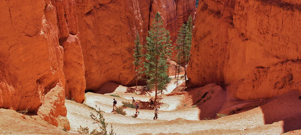
7. Sunset Point and the Rim Trail
Catch your breath at Sunset Point, then walk the paved Rim Trail about half a mile back to Sunrise Point.
Why clockwise? The park recommends going down Queen’s Garden and up the Navajo Loop because most injuries happen on the steep Navajo side when people come down it.
Current Closures and Conditions
- The park has posted trail closures after recent rains this fall, and the Wall Street side of the Navajo Loop has been closed after storm damage before.
- Wall Street also closes every winter.
- Queen’s Garden itself isn’t normally closed for the season, but snow, ice or rockfall can close parts briefly.
Check the Bryce Canyon conditions page before you go.
Best Time to Hike
| Season | What to expect |
|---|---|
| May–June, September–October | Best: mild days, cold mornings, shuttle running |
| July–August | Warm days, afternoon thunderstorms. Hike in the morning. |
| November–March | Snow on red rock is magical. Icy trails, Wall Street closed. Bring traction. |
| April | Mixed: some snow and ice may linger |
Time of day: start at sunrise for soft light, cool air and fewer people. Afternoons bring crowds and, in summer, storms.
Winter Hiking Tips
- Wear microspikes or similar traction. The trails get icy, especially in shade.
- Bring warm layers. Mornings can be well below freezing.
- Use the Two Bridges side for the loop, since Wall Street is closed.
- Days are short; start by midday.
Photo Spots
- Sunrise Point at dawn: the whole amphitheater glowing.
- The tunnels on Queen’s Garden: natural frames.
- Queen Victoria from the spur’s end.
- Thor’s Hammer from the Two Bridges side.
- The switchbacks, looking down from near Sunset Point.
What to Bring
- Water: at least 1–2 liters per person. There’s a seasonal refill station near the General Store.
- Shoes with grip for sandy, steep grades.
- Sun protection: the sun is strong at 8,000 feet.
- Layers and a rain jacket.
- Traction devices in winter.
- Snacks.
Safety Tips
- Pace yourself on the climb; altitude is real.
- Head for safety if you hear thunder; lightning strikes the rim.
- Don’t cut switchbacks or climb on hoodoos.
- Stay back from the rim edge.
- Respect closures, especially Wall Street.
Queen’s Garden vs. Other Bryce Hikes
| Trail | Distance | Difficulty | Highlight |
|---|---|---|---|
| Rim Trail (Sunset–Sunrise) | 1 mi round trip | Easy | Amphitheater views |
| Queen’s Garden | 1.8 mi | Moderate | Hoodoos, Queen Victoria |
| Navajo Loop | 1.3 mi | Moderate | Switchbacks, Thor’s Hammer |
| Queen’s Garden–Navajo | 2.9 mi | Moderate | Best of both |
| Figure-8 (with Peekaboo) | 6.4 mi | Strenuous | More hoodoos, fewer people |
| Fairyland Loop | 8 mi | Strenuous | Quiet, long hoodoo hike |
A Simple Half-Day Plan
- Sunrise: watch the light from Sunrise Point.
- Morning: hike down Queen’s Garden, see Queen Victoria, and climb the Navajo Loop to Sunset Point.
- Late morning: walk the Rim Trail back, then drive to Inspiration Point and Bryce Point for more views.
Heading on to Zion? See our guides to Emerald Pools and driving from Las Vegas to Zion.
Frequently Asked Questions
How long is Queen’s Garden Trail?
1.8 miles round trip from Sunrise Point.
How long is the Queen’s Garden–Navajo Loop?
2.9 miles, about 2–3 hours, with about 625 feet of climbing.
Is Queen’s Garden hard?
It’s moderate, the easiest trail into the amphitheater, but you climb back up at high altitude.
Which direction should I hike the loop?
Clockwise: down Queen’s Garden, up the Navajo Loop.
Where are the famous switchbacks?
On the Navajo Loop just below Sunset Point.
Is Wall Street open?
It closes in winter and has closed after storm damage. Check the park’s conditions page.
Can I hike Queen’s Garden in winter?
Usually yes, with traction devices and warm layers.
Are dogs allowed?
No, pets aren’t allowed on trails below the rim.
Is there a shuttle?
Yes, roughly April to October, stopping at Sunrise and Sunset Points.
Is Queen’s Garden worth it?
Absolutely. It’s the best short way to walk among Bryce’s hoodoos.
Final Thoughts
Queen’s Garden turns Bryce from a view into an adventure. Do the 1.8-mile out-and-back if you want something easy, or the 2.9-mile loop for the full experience. Start early, take the climb slowly, and check which side of the Navajo Loop is open.
More hikes: Delicate Arch, Emerald Pools in Zion and the best winter hiking trails in the USA.
Official info: NPS: Queen’s Garden & Navajo Combination and Bryce Canyon conditions.