
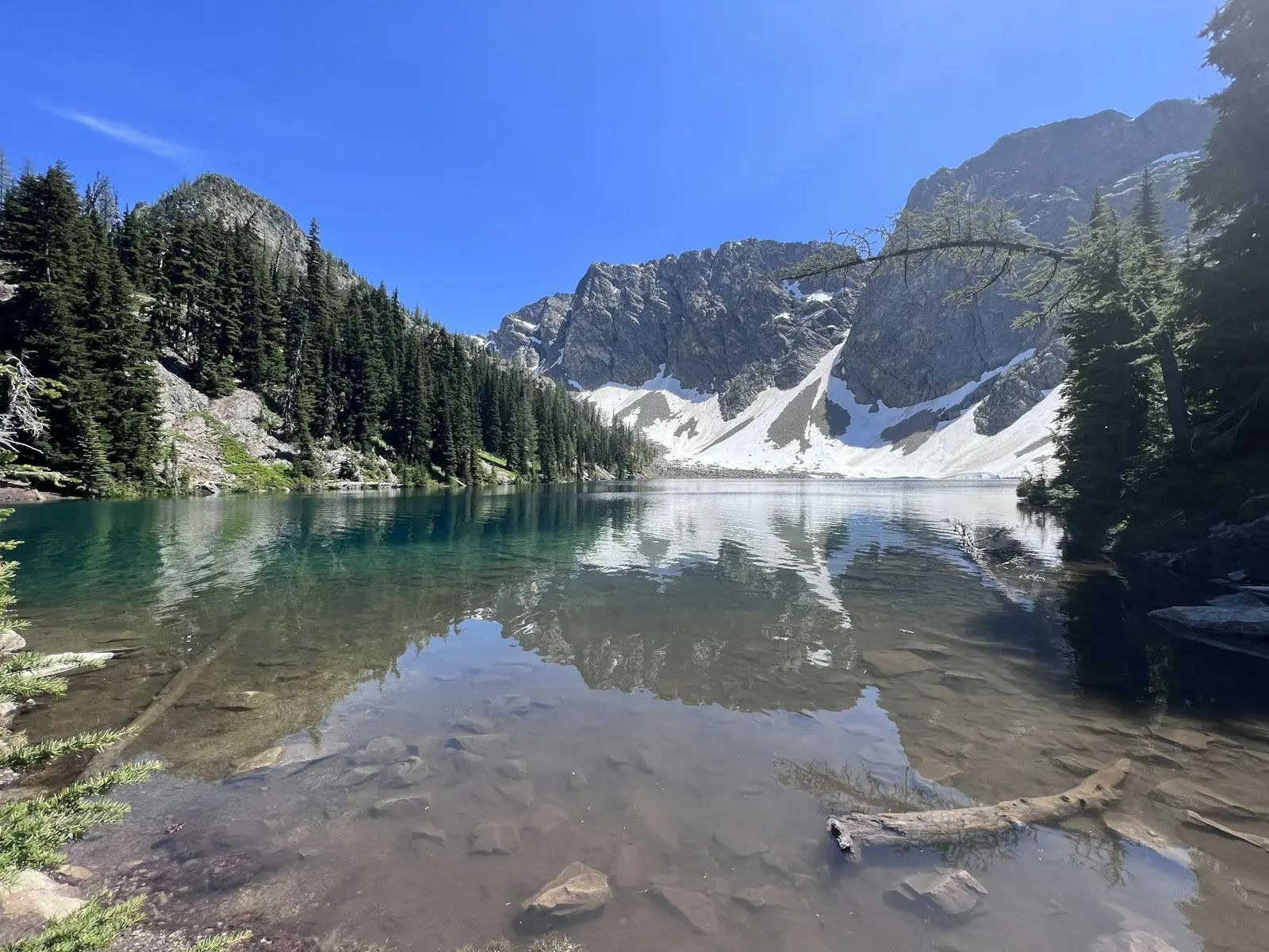
Lake 22 is the hike a lot of Seattle people take their visiting friends on, and for good reason. In under three miles you go from giant mossy cedars and roaring creeks to a cold green lake sitting right under the sheer north face of Mount Pilchuck, with waterfalls pouring down the cliffs.
The Lake 22 Trail in Washington (officially Lake Twentytwo Trail #702) is close to the city, well built and not too long. But it’s steeper and rockier than many people expect, the lot fills early, and in winter and spring the lake basin is avalanche terrain.
This guide gives you the real numbers, what each part of the trail is like, how to park, and how to time your visit.
Quick answer
- Distance: 5.4 miles round trip. Add about 1.2 miles to walk the loop around the lake.
- Elevation gain: about 1,350 feet.
- High point: about 2,400 feet.
- Time: 3–4 hours.
- Difficulty: moderate. Steady climb with rocky steps and roots.
- Trailhead: Mountain Loop Highway, about 2 miles past the Verlot Public Service Center (east of Granite Falls).
- Pass: Northwest Forest Pass or America the Beautiful pass.
- Best time: July to October. Winter and spring bring avalanche danger.
- Dogs: allowed on a leash.
Lake 22 Trail at a Glance
| Official name | Lake Twentytwo Trail #702 |
| Land manager | Mount Baker–Snoqualmie National Forest |
| Location | Mountain Loop Highway, near Granite Falls, Washington |
| Distance | 5.4 miles round trip (about 6.6 with the lake loop) |
| Elevation gain | About 1,350 feet |
| Trailhead elevation | About 1,100 feet |
| Lake elevation | About 2,400 feet |
| Difficulty | Moderate |
| Parking | Gravel lot, roughly 50 cars, plus overflow |
| Toilet | Privy at the trailhead |
| Cell service | None on the trail |
Where Is Lake 22?
Lake 22 sits on the north side of Mount Pilchuck in the western Cascades, about an hour to an hour and a half from Seattle depending on traffic.
Directions
- Drive to Granite Falls (via SR-92 from I-5 or SR-9).
- Head east on the Mountain Loop Highway.
- Pass the Verlot Public Service Center, then continue about 2 miles.
- Just after crossing Twentytwo Creek, turn right into the signed Lake Twentytwo trailhead.
The road is paved to the trailhead. There’s no cell coverage once you leave Granite Falls, so download your map and directions before you go.
Parking and Passes
- You need a Northwest Forest Pass (day or annual) or an America the Beautiful pass. Display it on your dashboard. Day passes are sold online and at some local stores.
- The lot holds about 50 cars and fills by mid-morning on summer weekends.
- If it’s full, use signed overflow parking only. Don’t park on the highway shoulder where it’s posted.
- Arrive before 8 a.m. on weekends, or come on a weekday.
Why Is It Called Lake 22?
Nobody’s 100% sure. The most popular story is that old railroad maps numbered the local creeks, and this creek and its lake got the number 22. Another theory says it simply marks the section of forest the lake sits in. Either way, the name stuck.
In 1947, about 790 acres around the lake became the Lake Twentytwo Research Natural Area. That ended logging here, which is why you still get to walk through such big, old trees.
The Lake 22 Hike, Step by Step
1. Old-growth forest (first mile or so)
The trail starts gently, crossing small streams on bridges and boardwalks through a classic Pacific Northwest forest. Look for huge western red cedars, hemlocks, moss on every branch and ferns everywhere.
It’s lush, green and cool, even on a hot day. Roots and wet boardwalks can be slippery, so watch your footing.
2. Switchbacks along Twentytwo Creek
Soon the trail starts climbing for real, with steady switchbacks and lots of rock steps. You’ll hear Twentytwo Creek the whole way and pass several pretty waterfalls and cascades just off the trail.
This is where most people slow down. Take short breaks rather than pushing hard.
3. The talus field
Partway up, you leave the trees and cross an open slope of rocks (a talus field). This is a nice break from the forest. Look north for views of the peaks across the valley, including Three Fingers.
In warm weather this section can be hot. In winter and spring, it’s one of the places where avalanche danger matters.
4. Back into the forest and the final stretch
The trail re-enters big trees, climbs a bit more, then flattens out as you get close to the lake. Cross the bridge over the lake’s outlet stream, and Lake 22 appears in front of you.
5. Lake Twentytwo
The lake sits in a rocky bowl at the base of Mount Pilchuck’s steep north face. In early summer, waterfalls and snowmelt streams pour down the cliffs, and snow often lingers on the far shore well into the season.
A path with boardwalks loops around the lake, about 1.2 miles. It’s well worth doing when the trail is snow-free. The far side gives you the classic view back across the water.
Safety Warning: The Boulder Field and Avalanches
Two things at Lake 22 have caused deaths, so please read this part.
The boulder field
On the far side of the lake, a huge field of boulders and old snow runs up toward the cliffs. It looks fun to explore. Don’t. The Washington Trails Association warns that hikers have died scrambling up this boulder field. Stay on the lake loop trail.
Avalanche danger
From roughly November through May (sometimes later), snow builds up on Mount Pilchuck’s steep north face. Avalanches can run down the chutes, across the trail and all the way to the lake. People have died here in winter.
- Don’t walk the lake loop when there’s snow.
- Check the Northwest Avalanche Center forecast before any winter or spring visit.
- If the danger is moderate or higher, choose a different hike.
- Stay away from the bottom of slopes and snow chutes.
Also, never walk on the frozen lake. The ice is often thin, and snow bridges hide water underneath.
How Hard Is the Lake 22 Trail?
Lake 22 is a solid moderate hike. The distance is fine for most people, but the 1,350 feet of climbing comes mostly in the middle section, and the rocky steps make it slower than the numbers suggest.
Is it good for beginners and kids?
Yes for fit beginners and kids who are used to hiking, in summer conditions. Bring snacks, take breaks and give yourself plenty of time. Young kids may find the rocky steps tiring.
How Long Does It Take?
| Plan | Distance | Time |
|---|---|---|
| Trailhead to lake and back | 5.4 miles | 3–4 hours |
| With the lake loop | About 6.6 miles | 4–5 hours |
| Forest and lower waterfalls only | 2–3 miles | 1–1.5 hours |
Best Time to Hike Lake 22
| Season | What to expect |
|---|---|
| Late spring (May–June) | Big waterfalls and snowmelt, but snow may still cover the upper trail and lake basin. Check avalanche and trail reports |
| Summer (July–August) | Easiest conditions, busiest trailhead, snow patches can linger |
| Fall (September–October) | Fewer people, cooler air, moody clouds on Pilchuck |
| Winter (November–April) | Snowy and beautiful, but avalanche-prone; only for people with avalanche knowledge |
What to Bring
- Northwest Forest Pass or America the Beautiful pass
- Waterproof or water-resistant hiking shoes (the trail stays wet)
- A rain jacket and warm layer, even in summer
- 2 liters of water and snacks
- Offline map (no cell service)
- Microspikes in late fall or spring if there’s ice
Photography Tips
- The best lake view is from the far (south) side of the loop, looking back across the water.
- Calm mornings give the best reflections of Mount Pilchuck.
- Cloudy days are great for forest and waterfall photos. The soft light makes the greens glow.
- Bring a cloth for your lens. Mist and spray are common.
Lake 22 vs. Other Hikes Near Seattle
| Hike | Effort | Best for |
|---|---|---|
| Lake 22 | Moderate | Old growth, waterfalls and a mountain lake |
| Rattlesnake Ledge | Moderate | Quick climb to a big viewpoint over a lake |
| Mount Si | Hard | A serious leg workout with huge views |
| Colchuck Lake | Moderate–hard | Turquoise lake in the Enchantments area |
Frequently Asked Questions
How long is the Lake 22 hike?
5.4 miles round trip, or about 6.6 miles if you walk the loop around the lake.
How much elevation gain is on Lake 22?
About 1,350 feet, topping out around 2,400 feet.
Is Lake 22 hard?
It’s moderate. The climb is steady and rocky, but the distance is manageable for most people.
Do you need a pass for Lake 22?
Yes. A Northwest Forest Pass or America the Beautiful pass is required to park.
Can you hike Lake 22 in winter?
People do, but the route crosses avalanche terrain and there have been fatal avalanches. Only go with avalanche training and a safe forecast.
Are dogs allowed?
Yes, on a leash.
Can you swim in Lake 22?
It’s very cold, even in August. A quick toe dip is plenty for most people.
Is there cell service?
No. Tell someone your plans and bring an offline map.
Final Thoughts
Lake 22 packs some of the best of western Washington into one half-day hike: ancient cedars, loud waterfalls and a dramatic mountain lake. Go early for parking, wear shoes that can handle mud and rock, stay off the boulder field, and treat the winter season with real respect.
Love waterfalls and big trees? Try the Marymere Falls Trail in Olympic National Park, the Sol Duc Falls Trail or the Maple Pass Loop in the North Cascades.
Trail facts come from the Mount Baker–Snoqualmie National Forest and the Washington Trails Association. Check recent trip reports and the avalanche forecast before you go.