
Late-season note (checked October 22, 2026): The golden larches are mostly past their best for 2026, and recent hikers report mud, frost and slick spots. Colder air and possible snow showers are in the forecast for the high passes. The North Cascades Highway (Highway 20) closes every winter, usually some time between November and January, and the date is set by snow and avalanche danger. Check WSDOT’s North Cascades Highway page and recent trip reports before you drive.
Some hikes give you one big view at the end. The Maple Pass Loop Trail gives you one after another.
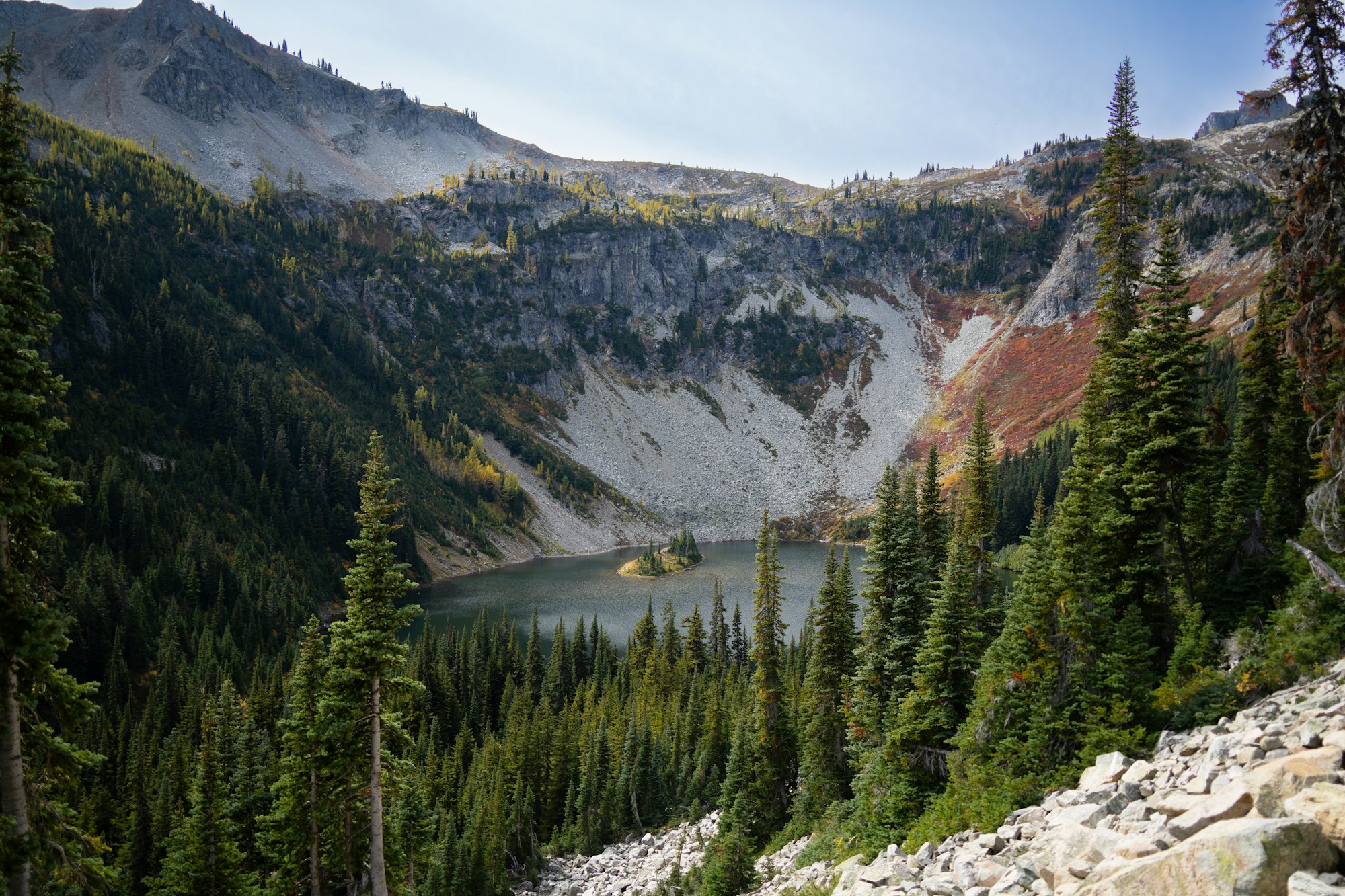
You start in a quiet forest. Then the trees thin out, the trail swings across open slopes, and suddenly you’re looking straight down at Lake Ann, a deep blue lake with a little tree-covered island in the middle. Keep climbing and you’re on a high ridge with jagged peaks all around. In late September, the larch trees turn bright gold, and the whole basin looks like it’s lit from inside.
The official name is the Heather–Maple Pass Loop, and it’s one of the most popular day hikes in Washington. It’s about 7.2 miles with roughly 2,000 feet of climbing. That’s a solid day, but no climbing skills are needed.
This guide covers everything: distance, difficulty, which direction to hike, the trail step by step, parking, the best time to go, larch season, weather, what to pack, dogs, and nearby hikes.
Cover photo: Lake Ann and its little island, seen from the trail. Photo: Alex Moliski / Unsplash
Maple Pass Loop Trail: Quick Facts
| Detail | Information |
|---|---|
| Official name | Heather–Maple Pass Loop (Trail #740) |
| Location | Rainy Pass, North Cascades Highway (Hwy 20), Washington |
| Distance | 7.2 miles (11.6 km) loop |
| Elevation gain | About 2,020 feet (616 m) |
| Highest point | About 6,650 feet |
| Trailhead elevation | About 4,850 feet |
| Difficulty | Moderate to hard |
| Time needed | 4 to 6 hours |
| Best season | Mid-July to early October |
| Larch season | Usually late September to early October |
| Parking pass | Northwest Forest Pass or America the Beautiful pass |
| Toilet | Vault toilet at the trailhead only |
| Water | None at the trailhead. Bring your own |
| Dogs | Leave them at home (see below) |
| Cell signal | Little to none |
Different apps show slightly different numbers. You’ll see 6.8 to 7.5 miles and 1,900 to 2,200 feet of gain. Plan for about 7.2 miles and 2,000 feet.
Is the Maple Pass Loop Open Now?
The trail itself doesn’t have a gate. What decides whether you can hike it is the road and the snow.
- The road: Highway 20 over Rainy Pass closes every winter. In 2026 it didn’t reopen until June 16, later than normal, after a December 2025 flood washed out parts of the road. When it closes for the season depends on the weather. The earliest closure on record was October 17.
- The snow: The steep slope near Maple Pass can hold snow well into July. In fall, the first storms can coat the ridge in snow and ice.
- Summer road work: In 2026, the Forest Service closed the Rainy Pass trailhead for a few days in mid-August for paving work. Watch for posted notices at the parking lot during summer projects.
Before you go, check WSDOT’s North Cascades Highway status, the mountain forecast for Washington Pass (not Seattle or Winthrop), and recent trip reports on the Washington Trails Association site.
Where Is the Maple Pass Loop?
The trail starts at Rainy Pass on the North Cascades Highway (State Route 20) in northern Washington. It’s in the Okanogan–Wenatchee National Forest, right on the edge of North Cascades National Park. That’s why you’ll see it listed as a national park hike, even though most of the trail is managed by the Forest Service.
| Driving from | Distance | Time (about) |
|---|---|---|
| Seattle | 130 miles | 2.5 to 3 hours |
| Marblemount | 50 miles | 1 hour |
| Mazama | 20 miles | 30 minutes |
| Winthrop | 35 miles | 45 minutes |
| Washington Pass Overlook | 5 miles | 10 minutes |
From the west, drive Highway 20 past Marblemount and Diablo Lake. The trailhead is on the right (south) side of the road at Rainy Pass, a few miles before Washington Pass. From the east, come up from Winthrop and Mazama over Washington Pass.
Download your map and directions before you leave. Cell service disappears soon after you leave the valleys.
How Hard Is the Maple Pass Loop?
Call it moderate to hard. The trail is well built and easy to follow in summer, and you won’t need to scramble. What makes it tiring is the mix: 7 miles, 2,000 feet up, and a steep 1,700-foot drop on the way down.
You’ll probably find it manageable if you can:
- Hike 5 or more miles with hills without needing a long recovery
- Climb steadily for an hour or more
- Walk downhill on loose, rocky trail without your knees complaining
Can beginners hike it?
Fit beginners can, on a clear summer day, with an early start and plenty of water. If you haven’t done much hiking, try the 2-mile Rainy Lake walk at the same trailhead first, or read our hiking for beginners guide before you go.
A good tip: if you’re tired by the time you reach the Lake Ann junction (about 1.25 miles in), the lake itself makes a great turnaround point.
Clockwise or Counterclockwise?
This is the question everyone asks. The views are the same either way. The difference is where the steep part is.
| Feature | Counterclockwise | Clockwise |
|---|---|---|
| Start | Dirt trail from the lot into the forest | Paved Rainy Lake path, then right fork at 0.5 miles |
| The climb | Gentler and longer | Steeper and shorter |
| The descent | Steep, about 1,700 feet in 2.5 miles | Gentler and longer |
| Lake Ann views | Build slowly as you climb | Come all at once from the top |
| Black Peak views | In front of you on the way up | Behind you on the way up |
| Best for | Strong knees, big views on the climb | Sore knees, getting the hard part done early |
Our take: Most people go counterclockwise. The climb is easier, and the views open up in front of you as you go. But if downhill hiking hurts your knees, go clockwise. You’ll climb the steep side and walk down the gentle side.
Trekking poles help a lot on the steep side, whichever way you hike it.

The Trail Step by Step (Counterclockwise)
1. Rainy Pass to the Lake Ann junction (0 to 1.25 miles)
From the parking lot, take the dirt trail heading into the trees. It climbs at a steady, friendly grade through evergreen forest. There’s not much to see yet, so settle into a pace.
At about 1.25 miles, you’ll hit the Lake Ann junction.
2. Optional side trip to Lake Ann (+0.6 miles)
Take the side trail for a short, mostly flat detour to the lake’s shore. It adds about 0.6 miles round trip. Lake Ann sits in a bowl of rock and talus, with a small island near the middle.
It’s a nice place for a snack, but honestly, the best views of Lake Ann are from above. If you’re short on time or energy, skip it and keep climbing.
3. Up to Heather Pass (about 2 miles in)
Back on the loop, the trail climbs out of the forest and traverses open slopes. In summer these are full of wildflowers: paintbrush, penstemon, monkeyflower and valerian. In fall, the low bushes turn red and orange.
About 0.75 miles past the Lake Ann turnoff, you’ll reach Heather Pass. A short side path leads to a rocky viewpoint. It’s a great place to rest before the big climb.
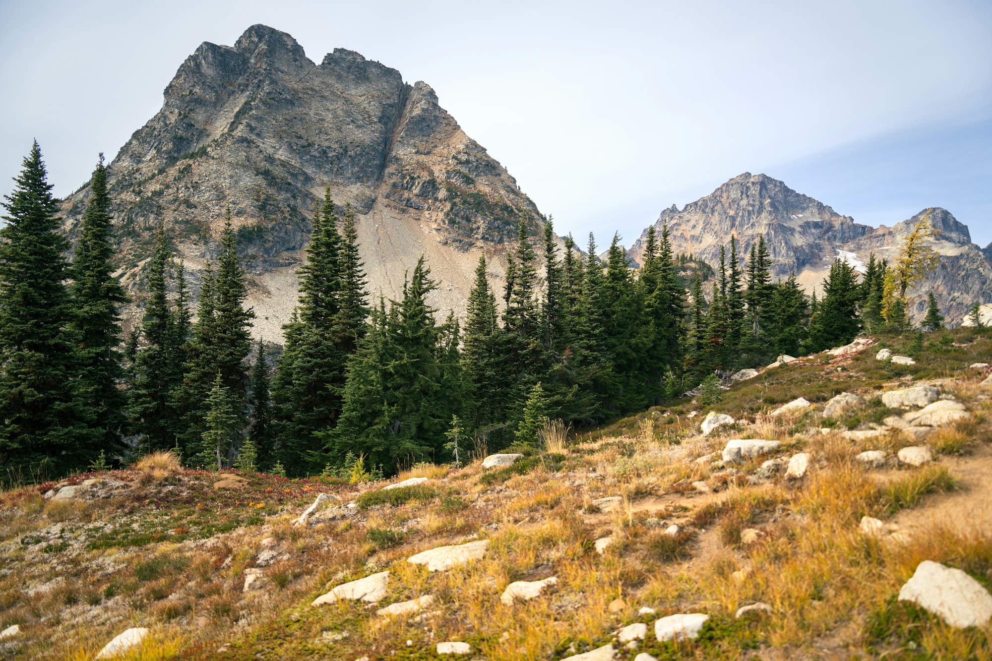
4. Along the ridge to Maple Pass (about 3.5 to 4 miles in)
This is the part people come for. The trail curves around the basin above Lake Ann, and the views just keep getting better. Black Peak rises in front of you. Look for Corteo Peak, Frisco Mountain and, on a clear day, peaks far to the south and west.
The last push up to Maple Pass is steep and fully exposed. This is also the slope that holds snow late into summer, so take care early in the season.
At the top, at about 6,650 feet, find a sheltered spot and enjoy it. You’ve done most of the climbing. It’s usually windy and much colder than the parking lot, so put on a layer.
Keep an eye out for ptarmigans, chunky, well-camouflaged birds that live up here year-round.
5. The steep way down (last 2.5 miles)
From the pass, the trail drops along a narrow ridge and then switchbacks hard down into the forest. You’ll lose about 1,700 feet in 2.5 miles. The trail can be dusty and loose in summer, and muddy or icy in fall. Take your time.
Near the end, you’ll join the paved Rainy Lake path. Follow it about half a mile back to the parking lot.
Lake Ann: What to Know
Lake Ann is the star of the hike. It sits in a glacier-carved bowl, called a cirque, with steep rock slopes on three sides. The small island in the middle makes it easy to spot in photos.
- From the loop, the side trip is about 0.6 miles round trip and nearly flat.
- If you only want to see the lake, you can hike to the shore and back as a shorter outing, about 3.5 miles round trip.
- The best photos are from the ridge between Heather Pass and Maple Pass, where you look straight down on the lake.
- The water is very cold all year. Swimming is for the brave.
Best Time to Hike Maple Pass
| Time of year | What it’s like | Our advice |
|---|---|---|
| June to mid-July | Snow on the upper slopes, wet trail | Check reports. Snow near the pass can be dangerous |
| Mid-July to August | Mostly snow-free, wildflowers, warm days | Great time. Start early to beat crowds and heat |
| September | Cooler days, fall colors start | Excellent. Weekdays are best |
| Late Sept to early Oct | Larches turn gold. Busiest time of year | Stunning, but arrive at sunrise |
| Mid to late October | Cold mornings, mud, frost, possible snow | For prepared hikers only |
| November to May | Deep snow. Highway closed for winter | Not a normal hike |
Our pick: a weekday in mid-September, or late September if you want the larches and can handle crowds.
Wildfire smoke can also roll in during late summer. Check air quality as well as the weather.
When Do the Larches Turn Gold at Maple Pass?
Larches are unusual trees. They have needles like a pine, but they turn gold and drop them in fall, like a maple. The North Cascades are one of the few places in Washington where you can see big stands of them, and Maple Pass is one of the most famous spots.
- Turning starts: around the third week of September
- Peak color: usually the last week of September through the first week of October
- Done: by mid-October in most years, often sooner after a storm
Timing shifts each year with the weather. Before you go, look at photos in recent trip reports to see how gold the trees are.

Tips for larch season
- Go on a weekday. Weekends in larch season are packed.
- Arrive before sunrise. The lot often fills very early.
- Bring a headlamp. Days are getting short.
- Dress for cold. Mornings at the pass can be below freezing.
- Have a backup hike. If the lot is full, Blue Lake or Cutthroat Lake are nearby.
Weather at Maple Pass
Mountain weather here changes fast. It can be warm and sunny at the car and cold, windy and cloudy at the top.
- The ridge is exposed. There’s no shelter from wind, rain or lightning.
- Afternoon thunderstorms happen in summer. If you hear thunder, get off the ridge.
- In fall, a sunny day can still mean below-freezing temperatures at the pass.
- Snow can fall at the pass in any month outside of high summer.
Always check the forecast for Washington Pass or Rainy Pass itself. A forecast for Seattle, Winthrop or Mazama won’t tell you what it’s like at 6,600 feet.
Parking at Rainy Pass
The Maple Pass Loop starts from the Rainy Pass Picnic Area on the south side of Highway 20. A separate lot across the road serves the Pacific Crest Trail.
- Spaces: about 40 cars
- Pass: Northwest Forest Pass or America the Beautiful pass, displayed on your dashboard
- Facilities: a vault toilet and picnic tables. No water, trash service or food
- When it fills: early on summer weekends and very early in larch season
Don’t park on the highway shoulder where it’s not allowed, and never block the road or gates. If the lot is full, it’s better to switch to another hike than to risk a ticket or a tow.
Permits and Rules
- Day hiking: no permit needed, just the parking pass.
- Camping: the Maple Pass Loop is best done as a day hike. Overnight rules differ between the national forest and the national park areas, so call the Methow Valley Ranger Station (509-996-4000) if you’re thinking of camping.
- Stay on the trail. Alpine plants grow very slowly, and shortcuts kill them.
- Pack out everything, including food scraps.
Are dogs allowed on the Maple Pass Loop?
Plan to leave your dog at home. Part of the upper loop crosses into the North Cascades National Park area, where pets aren’t allowed on trails. Service animals are the exception. If you have a dog with you, the Rainy Lake path is a better choice.
What to Pack
| Item | Why you need it |
|---|---|
| Hiking shoes with good grip | Loose rock, mud and steep downhill |
| Trekking poles | Saves your knees on the steep side |
| 2 liters of water or more | No water at the trailhead, few safe sources on the ridge |
| Lunch and snacks | You’ll be out 4 to 6 hours |
| Warm layer | It’s colder and windier at the pass |
| Rain jacket | Weather changes fast |
| Hat, sunglasses, sunscreen | The ridge has no shade |
| Offline map | No cell signal |
| Headlamp | Short days in fall, or a slow hike |
| Small first-aid kit | You’re a long way from help |
| Microspikes (fall only) | For icy patches after early storms |
Safety Tips
- Start early. You’ll get parking, cooler temps and more time.
- Tell someone your plan and when you’ll be back.
- Turn around if you see storms building, if the snow looks steep and icy, or if you’re running low on daylight.
- Watch your footing on the descent. Most slips happen on the way down.
- Don’t cross steep snow without the right gear and experience.
- Mind the wildlife. Black bears live here. Keep food packed away and never feed animals.
Other Hikes Near Maple Pass
If the lot is full, or you want something shorter, these are all close by on Highway 20.
| Trail | Distance (round trip) | Difficulty | Why go |
|---|---|---|---|
| Rainy Lake | About 2 miles | Easy, paved | Waterfall into a mountain lake. Good for families |
| Lake Ann only | About 3.5 miles | Easy to moderate | The famous lake, without the big climb |
| Blue Lake | About 4.4 miles | Moderate | Turquoise lake below Liberty Bell’s spires |
| Cutthroat Lake | About 4 miles | Easy to moderate | Quiet forest lake, more larches in fall |
| Cutthroat Pass (from Rainy Pass on the PCT) | About 10 miles | Hard | Huge views and larches on the Pacific Crest Trail |
| Washington Pass Overlook | Short paved walk | Easy | Classic view of Liberty Bell and Early Winters Spires |

Want a bigger North Cascades day? The Cascade Pass hike, on the west side of the park, is another classic with glaciers, meadows and huge views.
Sample Day Plan
| Time | What to do |
|---|---|
| 6:30 AM | Arrive at Rainy Pass (earlier on fall weekends) |
| 7:00 AM | Start the loop counterclockwise |
| 8:00 AM | Lake Ann junction (optional side trip) |
| 9:00 AM | Heather Pass break |
| 10:30 AM | Maple Pass. Lunch with a view |
| 11:00 AM | Start the descent |
| 12:30–1:00 PM | Back at the car |
| Afternoon | Stop at Washington Pass Overlook, then head to Winthrop or back west past Diablo Lake |
These times are for a steady summer pace. Add time for photos, breaks and crowds.
Where to Stay Near Maple Pass
There’s no lodging at Rainy Pass, so pick a base on one side of the pass or the other.
- Mazama and Winthrop (east side): The closest towns with lodges, cabins, food and gas. Winthrop has an Old West-style main street.
- Marblemount and Newhalem (west side): Smaller, with limited lodging, but handy if you’re also visiting Diablo Lake or Cascade Pass.
- Camping: There are Forest Service campgrounds along Highway 20 east of the pass, and national park campgrounds like Colonial Creek on the west side. Most are seasonal, and many need a reservation in summer.
For larch season, book early. The few places to stay fill up fast.
Maple Pass Loop FAQs
How long is the Maple Pass Loop Trail?
About 7.2 miles as a full loop, plus about 0.6 miles if you take the side trip to Lake Ann’s shore.
How hard is the Maple Pass Loop?
It’s moderate to hard. You’ll climb about 2,000 feet, and the steep side drops about 1,700 feet in 2.5 miles. There’s no scrambling.
How long does it take?
Most hikers take 4 to 6 hours, including breaks.
Should I hike Maple Pass clockwise or counterclockwise?
Counterclockwise has an easier climb and great views ahead of you. Clockwise is better if steep downhills hurt your knees.
When is the best time to hike Maple Pass?
Mid-July through September for good conditions. Late September to early October for golden larches.
When do the larches peak at Maple Pass?
Usually the last week of September through the first week of October. Check recent trip reports, because it shifts each year.
Do you need a permit for the Maple Pass Loop?
No permit is needed for day hiking. You do need a Northwest Forest Pass or America the Beautiful pass to park.
Is Maple Pass in North Cascades National Park?
Most of the trail is in the Okanogan–Wenatchee National Forest. The upper part runs along the edge of the national park area.
Are dogs allowed on the Maple Pass Loop?
No. Part of the loop crosses into national park land, where dogs aren’t allowed on trails.
Can you hike the Maple Pass Loop in October?
Early October, yes, if the weather is good. By mid to late October, expect cold, mud, ice and possible snow, and always check that Highway 20 is open.
Is there water on the trail?
No. There’s no water at the trailhead, and the ridge is dry. Bring at least 2 liters.
Is the Maple Pass Loop worth it?
Yes. For the effort, few hikes in Washington give you this many big views: a jewel of a lake, sharp peaks, meadows and, in fall, gold larches.
Final Thoughts
The Maple Pass Loop packs a lot into seven miles. Forest, wildflowers, a perfect blue lake, and a high ridge with peaks in every direction. Start early, bring layers and plenty of water, and pick your direction based on your knees.
Planning more mountain hikes? See how Maple Pass compares with the volcanic scenery of the Bumpass Hell Trail in California or the crater-rim views from Garfield Peak in Oregon.