
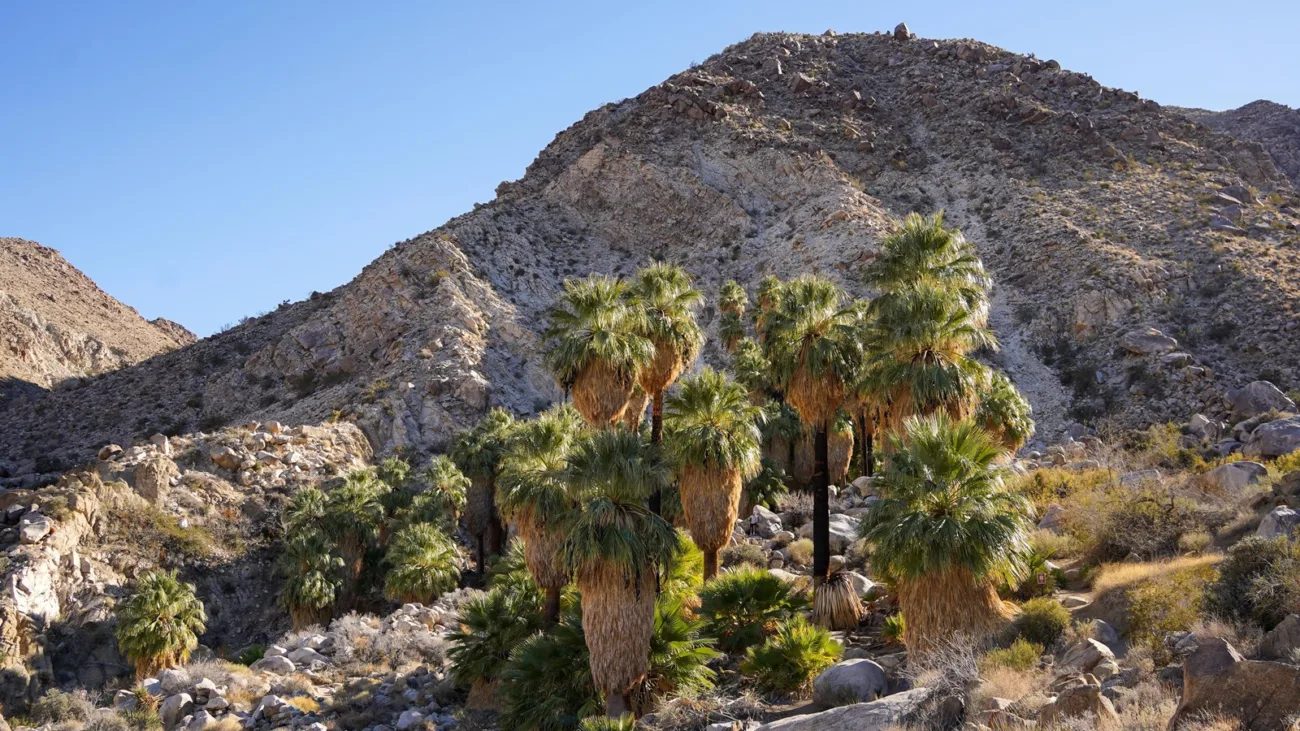
You climb a rocky ridge in the hot desert sun, cross over the top, and there it is below you: a cluster of tall green palm trees tucked into a dry canyon, like something out of a movie. That’s Fortynine Palms Oasis, one of the few places in Joshua Tree where water comes out of the ground.
The Fortynine Palms Oasis Trail is a 3-mile out-and-back hike in the quieter northern part of the park, near Twentynine Palms. It’s short, but the park rates it difficult because you climb in both directions, with almost no shade.
There’s one more thing you must know before driving out: the trail closes seasonally to protect bighorn sheep. This guide explains the closures, directions, parking, the route step by step, the best time to go and how to stay safe.
Quick answer
- Distance: 3 miles round trip, out and back.
- Elevation gain: about 300 feet each way (up over a ridge, down to the oasis, then back up).
- Time: 2–3 hours.
- Difficulty: difficult (NPS rating).
- Trailhead: end of Canyon Road, off Highway 62, west of Twentynine Palms.
- Open: usually fall, winter and spring only. Closed in summer for bighorn sheep, and the reopening date changes each year.
- Dogs: not allowed.
- Before you go: check the NPS Joshua Tree alerts page for the current status.
Fortynine Palms Oasis Trail at a Glance
| Location | Northern edge of Joshua Tree National Park, near Twentynine Palms, California |
| Distance | 3 miles (4.8 km) round trip |
| Elevation gain | About 300 feet each direction |
| Time | 2–3 hours |
| Difficulty | Difficult |
| Route | Out and back |
| Surface | Compact dirt, rocks and steps |
| Facilities | Parking (cars and RVs), vault toilet, info board; no water |
| Shade | Almost none until the oasis |
| Pets | Not allowed |
| Use | Day use only; no camping at the oasis |
Is Fortynine Palms Oasis Trail Open? (Closures Explained)
This is the most important part of planning. According to the National Park Service:
- The trail is open only in fall, winter and spring.
- It’s usually closed in summer (the park’s summer closure list gives June 1 to September 30), along with the parking area, so desert bighorn sheep can reach the spring without people around. In drought years, the sheep depend on this water even more.
- The reopening date changes every year. The closure can stay in place until summer monsoon rains add more water to the area.
- Storm damage can also cause closures. In early 2026, for example, the park limited the trail to weekends while crews repaired rain damage.
What to do: check the NPS Joshua Tree alerts and conditions page on the day you plan to go. Don’t trust an old blog post or app review. If it’s closed, never go around the gate. Pick another hike instead, like Ryan Mountain or Barker Dam.
Where Is the Trailhead?
Fortynine Palms is in a separate northern section of the park. You can’t drive there on the main park roads. Instead, you reach it from the town side, off Highway 62, between Indian Cove and Twentynine Palms.
Directions
- Drive Highway 62 (Twentynine Palms Highway) to the west side of Twentynine Palms.
- Turn south on Canyon Road.
- Follow it south (it bends east near the end) for roughly 2 miles to the trailhead parking lot.
The road is paved and fine for normal cars. It’s about 10–15 minutes from the Joshua Tree Visitor Center in Twentynine Palms. Search for “Fortynine Palms Oasis Trailhead” in your map app.
Parking and fees
There’s a parking lot with spaces for cars and RVs, plus a vault toilet. There’s no entrance station here, but the area is inside the national park, so the park’s entrance fee rules still apply. Carry your pass or receipt.
Why Does a 3-Mile Hike Feel So Hard?
Most trails go up and then down. Fortynine Palms goes up, then down, then up again, then down:
- You climb about 300 feet from the parking lot to a ridge.
- You drop about 300 feet into the oasis canyon.
- On the way back, you climb out of the canyon to the ridge again, usually in the hottest part of your hike.
Add rocky steps and almost no shade, and it’s tougher than the distance suggests. Save energy and water for the return.
Step-by-Step: Hiking to the Oasis
1. The climb from the trailhead
The trail leaves the parking lot and heads straight up a rocky hillside. Look back for views over Twentynine Palms and the open desert to the north.
2. Barrel cactus slopes
The slopes are covered with round, spiny barrel cactus, some with red spines and yellow flowers in spring. Stay on the trail; they’re sharp.
3. The ridge
At the top of the ridge, the view opens into the mountains of the park. Keep watching ahead for a first glimpse of green.
4. Down into the canyon
The trail drops down rocky switchbacks into the canyon. Soon the palms appear, a surprising patch of green against brown rock.
5. The oasis
Tall California fan palms crowd around the spring, with pools and trickles of water in wet seasons. Their old fronds hang down like grass skirts. This is a great place for a snack in the shade. Please stay on the trail and out of the palm grove itself; the spring is wildlife’s water.
6. The return
Head back the same way, climbing out of the canyon and over the ridge to your car.
Why Is the Oasis Special?
Fan palm oases form only where underground water reaches the surface, often along fault lines. California fan palms are the only palm native to the western U.S., and they need steady water to survive. That makes Fortynine Palms a lifeline for birds, insects and bighorn sheep in a very dry land.
Are there exactly 49 palms? Probably not. The number changes as old trees die and new ones grow, and fires have burned the grove in the past. The name stuck anyway.
Wildlife
- Desert bighorn sheep: the reason for the closures. If you see them, stay still and quiet and keep your distance.
- Birds: the oasis draws hummingbirds, orioles and other songbirds, especially in spring.
- Lizards and, in warm weather, rattlesnakes. Watch where you step and put your hands.
Best Time to Hike
| Season | What to expect |
|---|---|
| Late fall (after reopening) | Cooler days, quiet trail. Check the reopening status. |
| December–February | Best weather; cold mornings, windy ridge. |
| March–April | Warm, flowers and birds; start early. |
| Summer | Usually closed; dangerously hot anyway. |
Start early in the morning so you’re climbing back over the ridge before it gets hot. Finish before dark. The rocky return is tricky with a headlamp.
Is It Good for Kids or Beginners?
Older kids who hike often can usually manage it on a cool day. It’s harder for young children because of the double climb and lack of shade. Strollers and wheelchairs can’t use the trail. If you want an easy palm oasis walk, try the short paved Oasis of Mara at the visitor center in Twentynine Palms (check that it’s open; storm damage closed it in 2025).
What to Bring
- Water: at least 2 liters per person, more if it’s warm. There’s no drinkable water at the oasis.
- Hiking shoes with grip.
- Hat, sunglasses and sunscreen.
- Salty snacks.
- Light jacket for winter mornings.
- Offline map and charged phone.
- Headlamp for emergencies.
Safety Tips
- Respect closures. They protect wildlife and you.
- Plan for the climb back. Keep half your water for the return.
- Avoid heat. Turn around if you feel dizzy, sick or stop sweating.
- Stay out of the grove and don’t swim or wade in the spring.
- No fires. Dry palm fronds burn fast.
- Tell someone your plans. Cell service is spotty.
Fortynine Palms vs. Other Joshua Tree Hikes
| Trail | Distance | Difficulty | Highlight |
|---|---|---|---|
| Fortynine Palms Oasis | 3 mi | Difficult | Palm oasis |
| Ryan Mountain | 3 mi | Difficult | Summit view |
| Hidden Valley | 1 mi loop | Easy | Giant boulders |
| Barker Dam | 1.1 mi loop | Easy | Dam and rock art |
| Lost Palms Oasis | About 7.5 mi | Strenuous | Largest palm oasis in the park |
Love palm oases? See our guide to Palm Canyon Trail in Borrego Springs.
Frequently Asked Questions
How long is Fortynine Palms Oasis Trail?
3 miles round trip.
How hard is it?
The park rates it difficult because you climb about 300 feet each way over a rocky ridge with no shade.
How long does it take?
2–3 hours.
Is the trail closed?
It’s usually closed in summer for bighorn sheep, and storms can cause other closures. Check the NPS alerts page before you go.
When does it reopen?
It changes every year, depending on rain and water levels.
Where is the trailhead?
At the end of Canyon Road, off Highway 62, on the west side of Twentynine Palms.
Do I need to pay?
There’s no gate here, but national park entrance fee rules still apply.
Can I swim in the oasis?
No. Stay out of the water and the grove.
Are dogs allowed?
No.
Is it worth it?
Yes. Seeing a palm oasis in the middle of the desert is unforgettable.
Final Thoughts
Fortynine Palms is a little desert miracle: a short but honest climb to a green oasis that wildlife depends on. Check that it’s open, start early, carry plenty of water, and leave the palms and spring just as you found them.
More Joshua Tree hikes: Ryan Mountain, Hidden Valley, Barker Dam and our full list of the best hikes in Joshua Tree.
Official info: NPS: Fortynine Palms Oasis Trailhead and Joshua Tree alerts and conditions.