
On a map, Hanksville barely registers. It’s a dot where two highways meet, with a gas station built into a rock and a couple hundred residents.
But draw a one-hour circle around it and you’ll find some of the strangest landscapes in Utah: grey moonlike badlands under Factory Butte, rainbow-striped clay hills near a Mars research station, thousands of sandstone goblins, slot canyons narrow enough to brush both walls, and the red cliffs and orchards of Capitol Reef.
The trick is fitting it all together without spending the trip in your car or hiking at the hottest hour. This Hanksville, Utah itinerary groups the sights by direction, puts each one at its best time of day, and gives you plans for one, two and three days, plus ideas for longer trips, summer and winter adjustments, and versions for families and photographers.
Hanksville Itinerary at a Glance
The best Hanksville, Utah itinerary is two to three days: Day 1 for the badlands (Moonscape Overlook at sunrise, Factory Butte and the Bentonite Hills at sunset), Day 2 for Little Wild Horse Canyon and Goblin Valley State Park, and Day 3 for Capitol Reef National Park.
| Day | Direction | Main Stops | Approx. Driving |
|---|---|---|---|
| Day 1 | West | Moonscape Overlook, Factory Butte, Mars Desert Research Station, Bentonite Hills | 60–70 miles |
| Day 2 | North | Little Wild Horse Canyon, Goblin Valley, Temple Mountain | 80–90 miles |
| Day 3 | West | Capitol Reef: Fruita, Hickman Bridge, Scenic Drive | About 90 miles |
| Alternative Day 3 | South | Highway 95: Little Egypt, Leprechaun Canyon, Hite Overlook | About 90 miles |
Only two days? Do Days 1 and 2. Three days? Add Capitol Reef. Rain in the forecast? Swap days around. Wet clay roads and slot canyons are no place to stick to a plan.
How Many Days Do You Need in Hanksville?
Two full days covers the highlights: the badlands, Little Wild Horse Canyon and Goblin Valley. Three days is better, because it adds Capitol Reef National Park and gives you slack for weather. Four or more days lets you reach remote places like Horseshoe Canyon, Cathedral Valley and the Henry Mountains.
| Trip Length | Best For | What You’ll See |
|---|---|---|
| 1 day | Passing through | Goblin Valley plus one badlands viewpoint |
| 2 days | Most first-timers | Badlands, Little Wild Horse, Goblin Valley |
| 3 days | Best overall | Everything above plus Capitol Reef |
| 4–5 days | Photographers and explorers | Add Horseshoe Canyon, Cathedral Valley, Highway 95 or the Henry Mountains |
Since Hanksville is a base rather than a destination, aim for two or three nights. That way you can be out at sunrise and sunset without long drives at the end of the day.
Getting to Hanksville
Hanksville sits at the junction of Highways 24 and 95 in south-central Utah. There’s no airport or public transport, so you’ll need a car.
| From | Approx. Drive | Route |
|---|---|---|
| Torrey / Capitol Reef | 1 hour | Highway 24 east |
| Green River | 1 hour | Highway 24 south from I-70 |
| Moab | About 2 hours | I-70 west, then Highway 24 south |
| Bryce Canyon | 2.5–3 hours | Scenic Byway 12, then Highway 24 |
| Salt Lake City | 3.5–4 hours | I-15 and Highway 24 |
| Las Vegas | 5–5.5 hours | I-15, I-70 and Highway 24 |
Coming from Moab? Stop at Goblin Valley on the way in. It sits just off Highway 24 between Green River and Hanksville, which can save you a drive later.
Best Time for This Itinerary
This plan works best from April to May and late September to October, when days are mild and nights are cool. In summer, temperatures near 100°F and monsoon flash floods from July to September change everything. See the summer adjustments below. For month-by-month details, read our guide to the best time to visit Hanksville, Utah.
Day 1: The Badlands (Moonscape, Factory Butte and the Bentonite Hills)
Day 1 is all about the landscape that gives Hanksville its “Mars on Earth” reputation. Everything is west of town, so you’ll make two short outings, at sunrise and sunset, with a long break in between.
Before Sunrise: Drive to the Moonscape Overlook
Leave Hanksville about an hour before sunrise. Take Highway 24 west about 10 to 11 miles, turn north onto Factory Butte Road (BLM Road 0091), then follow BLM Road 0913 toward the Skyline Rim to the end of the road. Plan on 40 to 50 minutes.
Download offline maps the night before. Signs use BLM road numbers, cell service is patchy, and the last stretch is rough, so high clearance is recommended. If it has rained recently, skip it. The clay roads turn slick and impassable, even for 4x4s.
Sunrise: Moonscape Overlook
The overlook faces east over a huge basin of rippled grey badlands, so it’s at its best right as the sun comes up, when soft pinks and purples settle over the hills. There’s no hike: the view is steps from where you park. There are also no railings, restrooms or water, and the rim is crumbly, so stay well back from the edge. See our Moonscape Overlook, Utah guide for photo tips.
Morning: Factory Butte
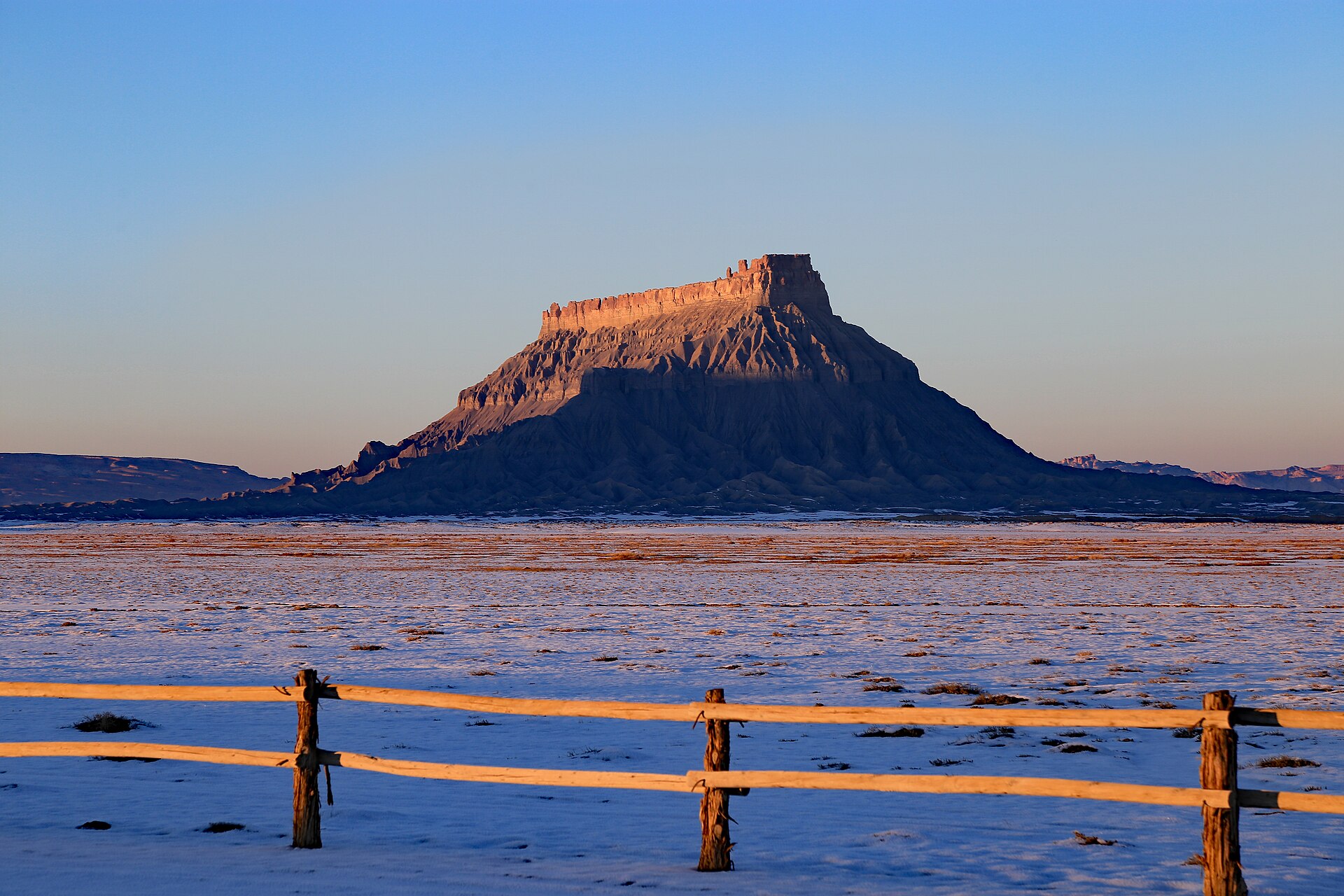
On the drive back out, stop near the junction with the Moonscape road for views of Factory Butte, a huge mesa rising about 1,400 feet above the grey hills. The best views are often from a distance, where you can see the whole butte above the badlands. In spring, look for wildflowers and blooming cacti after wet winters. Stay on established roads, since the clay crust and rare plants here are easily damaged. More details are in our Factory Butte, Utah guide.
Late Morning to Afternoon: Rest in Hanksville
Head back to town for a late breakfast or early lunch. Midday light flattens the badlands, and in warm months the heat is intense, so this is the time to recharge. Take your photo at Hollow Mountain, the gas station carved into a rock, and stop by the historic Wolverton Mill behind the BLM office. Ask the BLM staff about road conditions for tomorrow while you’re there. Grab a burger at Stan’s Burger Shak, refill your water and rest.
Want more action? Local outfitters run guided UTV tours of the badlands and Factory Butte area, and Swing Arm City, a popular off-road riding area, is just west of town.
Late Afternoon: Mars Desert Research Station
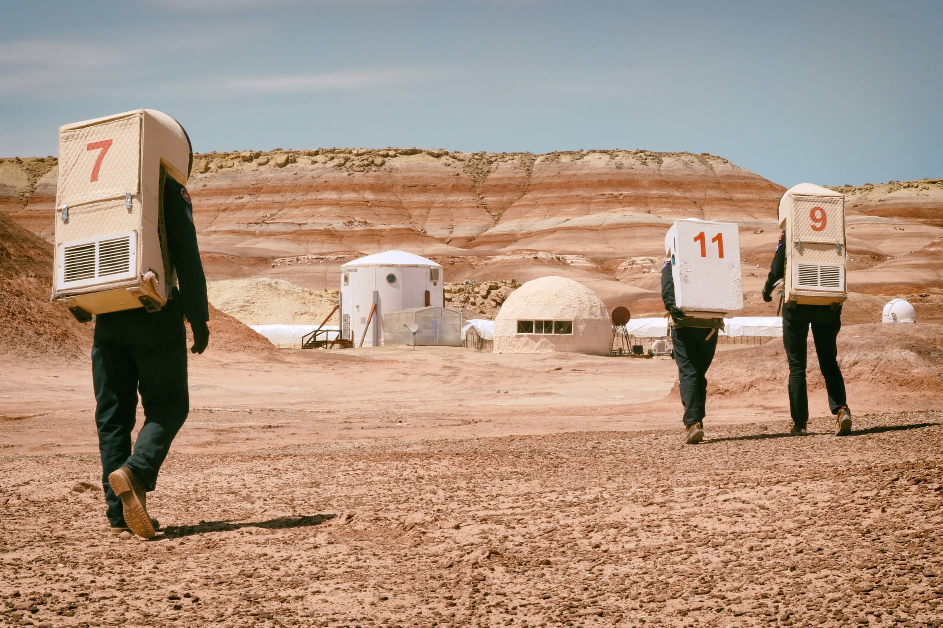
Head a few miles west on Highway 24 and turn onto Cow Dung Road. After about 3 miles of dirt, you’ll pass the Mars Desert Research Station, a white habitat where crews practice living as if they were on Mars. It’s private and closed to visitors, so view it from the road and keep drones away.
Sunset: The Bentonite Hills
Keep going a few miles past the station to the most colorful Bentonite Hills, rounded mounds striped purple, red, cream and grey. They glow at sunset and stay beautiful through blue hour. Walk only in the washes, not on the slopes, since footprints in the soft clay last for years. This sunset spot is only about 20 to 25 minutes from town, so you won’t face a long, dark drive back.
Night: Stargazing
With almost no lights for miles, the stars around Hanksville are spectacular. Pull off at a safe spot outside town, turn off your headlights and give your eyes time to adjust. Then get some sleep. Day 2 starts early.
Day 2: Little Wild Horse Canyon and Goblin Valley
Day 2 heads north. Little Wild Horse Canyon and Goblin Valley sit just a few miles apart, so they make a perfect pair. (For fees, hours and more tips, see our Goblin Valley from Hanksville guide.) Hike the slot canyon in the cool morning, then spend the afternoon and evening with the goblins.
7:00 a.m.: Leave Hanksville
Take Highway 24 north about 20 miles to the Temple Mountain Road junction, then follow the signs west. The road to Goblin Valley is paved the whole way. If your GPS tries to send you onto a dirt shortcut, ignore it. That’s not the right route. Little Wild Horse’s trailhead is a few minutes past the Goblin Valley turnoff. Pack a picnic lunch and more water than you think you’ll need.
8:00 a.m.: Hike Little Wild Horse Canyon
Little Wild Horse is one of the best non-technical slot canyons in Utah. After a sandy start, the walls close in until you’re turning sideways to squeeze through. The trailhead has parking, vault toilets and an information kiosk.
You have two options:
- Short out-and-back (2–3 hours): walk up Little Wild Horse through the best narrows, then turn around. Best if you want plenty of time at Goblin Valley, or if you’re hiking with kids.
- Full loop (4–6 hours): the roughly 8-mile loop goes up Little Wild Horse, crosses on an old jeep track and returns down Bell Canyon. The connector is completely exposed, so bring at least 2 to 3 liters of water each.
The most important rule in this whole itinerary: never enter the canyon if rain is possible anywhere in the area. Flash floods here can be deadly, and a storm miles away can send water through on a clear day. If the forecast is questionable, skip the canyon and spend more time in Goblin Valley.
Noon: Picnic Lunch
There’s no food out here, so eat your packed lunch in the shade near the trailhead or at the Goblin Valley pavilion. Drink before you feel thirsty.
1:00 p.m.: Goblin Valley State Park
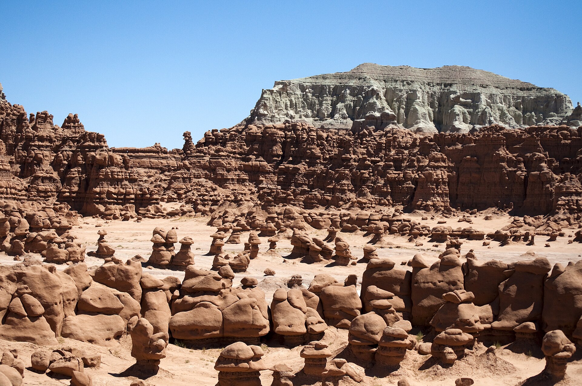
The park is open daily from early morning until late evening, with a visitor center during the day, and charges a per-vehicle day-use fee (currently $20). National park passes don’t work here. Start at the observation point to take in the scale of the valley, then walk down and wander among the hoodoos. There’s no set trail in the main valley. Don’t climb on the goblins or move rocks.
Midday is the hottest and harshest-lit part of the day here, so if it’s warm, explore for an hour, then cool off in the shade or the car and come back later.
Optional: Carmel Canyon or Temple Mountain
Still have energy? The Carmel Canyon Loop is a short hike of about 1.5 miles round trip with a small narrows and some scrambling. Or drive a few minutes to Temple Mountain to see old uranium mining relics and ancient pictographs near the road. Stay out of old mine shafts, though. After the full Little Wild Horse loop, you may decide you’ve done enough, and that’s fine.
Sunset and Night: Goblin Valley Under the Stars
Late afternoon is when Goblin Valley comes alive. Long shadows give every hoodoo a face, and the crowds thin out. Stay for sunset, then stick around for the stars. Goblin Valley is a certified International Dark Sky Park. If you’ve booked a site or a yurt in the park campground, you can wander back into the valley by headlamp. Otherwise, it’s about 40 to 45 minutes back to Hanksville. Watch for wildlife on the road.
Day 3: Capitol Reef National Park
If you have a third day, don’t squeeze more badlands into Days 1 and 2. (For more detail, see our Capitol Reef from Hanksville day trip guide.) Use it for Capitol Reef, which changes the scenery completely: red cliffs, domes, arches, cottonwoods and historic orchards. The visitor center is about 37 miles west of Hanksville on Highway 24.
7:30 a.m.: Drive West on Highway 24
The drive is part of the day. You’ll pass through tiny Caineville, follow the Fremont River into a canyon, and watch the Waterpocket Fold rise ahead. Driving Highway 24 through the park is free; the Scenic Drive has an entrance fee, and national park passes are accepted.
8:30 a.m.: Hickman Bridge and the Petroglyphs
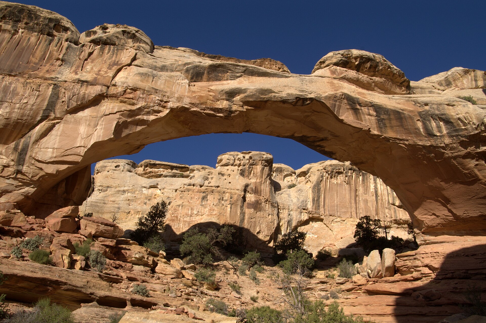
Start early at the Hickman Bridge trailhead, since parking fills by mid-morning in spring and fall. The trail is about 1.8 miles round trip and ends beneath a big natural stone bridge. Afterward, stop at the Fremont petroglyph panel boardwalk along Highway 24 to see ancient carvings of people and bighorn sheep.
10:30 a.m.: Visitor Center and Fruita
Stop at the visitor center for current road and trail conditions, which change often here. Then walk around historic Fruita, with its old schoolhouse, barns and orchards along the Fremont River. Buy a fruit pie at the Gifford Homestead when it’s open, since they often sell out by early afternoon. In season, you can pick fruit in the orchards that are open for picking.
Noon: Lunch
Picnic in the shady Fruita picnic area, or drive about 15 minutes west to Torrey, which has more restaurants than Hanksville.
1:30 p.m.: The Scenic Drive and One More Hike
The paved Scenic Drive runs about 7.9 miles one way. Allow around an hour and a half round trip with stops. Dirt spurs lead into Grand Wash and Capitol Gorge, both easy, flat walks between towering walls. Capitol Gorge has the Pioneer Register, where early settlers carved their names in the rock. Check that the spur roads are open, and avoid canyon walks if storms threaten.
Want something harder? Cassidy Arch is about 3.4 miles round trip with a steep climb to the top of an arch named for Butch Cassidy. Pick one hike. Day 3 doesn’t need to be a marathon.
Evening: Back to Hanksville or On to Torrey
If you’re continuing west, spend the night in Torrey and head out on Scenic Byway 12 tomorrow. If you’re returning to Hanksville, the evening light on the badlands along Highway 24 is beautiful. Just skip any complicated dirt-road detours at the end of a long day.
Alternative Day 3: Highway 95 to Lake Powell
Already visiting Capitol Reef on another part of your trip? Head south instead on Highway 95, one of the emptiest, prettiest roads in Utah. Fill your tank first, because services are almost nonexistent.
- Little Egypt Geologic Site (about 20 miles): a free mini field of hoodoos, usually empty.
- Leprechaun Canyon (about 30 minutes): a short walk into a dramatic, shaded slot. Turn back when it gets technical, and stay out if rain is possible.
- Hog Springs: a shady picnic area with an easy streamside trail and nearby rock art.
- Hite Overlook (about 45 minutes): big views over the top of Lake Powell and the Colorado River bridge.
In summer, keep going to Bullfrog Marina for a swim or boat rental on Lake Powell.
One Day in Hanksville
Just passing through? Here’s the best of Hanksville in one long day:
| Time | Plan |
|---|---|
| Sunrise | Moonscape Overlook (dry roads only), or Factory Butte from the road |
| Morning | Goblin Valley State Park |
| Late morning | Short out-and-back in Little Wild Horse Canyon (no rain forecast) |
| Afternoon | Lunch and Hollow Mountain in Hanksville |
| Sunset | Bentonite Hills near the Mars Desert Research Station |
Have 4 or 5 Days? Add These
Horseshoe Canyon and the Great Gallery
A full-day adventure to one of North America’s most important rock art panels. You’ll drive about 30 miles of graded dirt road, then hike about 7 miles round trip with a steep 750-foot descent and climb. Go only in dry weather and avoid summer afternoons.
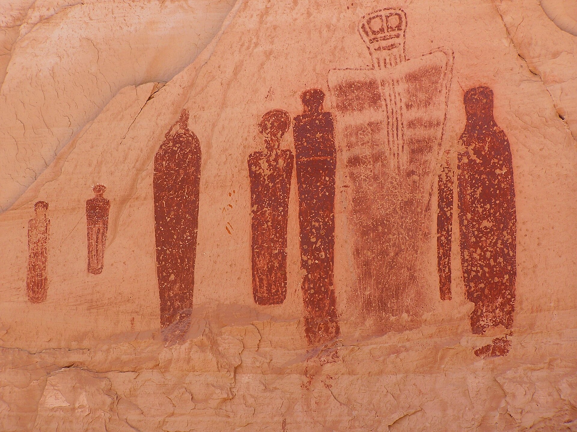
Cathedral Valley
Take the Caineville Wash Road from Highway 24 to the Temples of the Sun and Moon and Glass Mountain in Capitol Reef’s remote north. You’ll need a high-clearance vehicle and dry roads. Allow most of a day.
The Henry Mountains
In summer and early fall, escape the heat in these 11,000-foot peaks south of town, home to free-roaming bison. Roads are rough dirt, best for 4x4s, and usually snowed in from late fall to late spring. Ask at the BLM office first.
How Hanksville Fits Into a Bigger Utah Road Trip
Hanksville is the natural link between Moab and Utah’s western parks. A classic route runs:
Moab (Arches and Canyonlands) → Goblin Valley → Hanksville → Capitol Reef → Torrey → Scenic Byway 12 → Bryce Canyon → Zion
Give Hanksville two nights in the middle of that route and you’ll see a side of Utah most road-trippers drive straight past. For the next stops, see our guides to things to do in Bryce Canyon National Park and things to do in Zion National Park.
Where to Stay for This Itinerary
Stay in Hanksville for Days 1 and 2. It’s closest to the badlands, Goblin Valley and Highway 95, and it has fuel and food. Options include simple motels such as the Whispering Sands Motel and Red Sands Hotel, cabins, and RV and tent sites at Duke’s Slickrock Campground. Rooms are limited, so book early for spring and fall.
For something unique, book a campsite or yurt inside Goblin Valley for the night of Day 2. If Day 3 ends your Hanksville stay and you’re continuing west, move to Torrey after Capitol Reef. Compare all your options in our guide to where to stay in Hanksville, Utah.
| Stay in Hanksville If… | Stay in Torrey If… |
|---|---|
| The badlands, Goblin Valley and slot canyons are your priority | Capitol Reef is your main focus |
| You want to be out at sunrise near Factory Butte | You want more restaurants and lodging choices |
| You’re heading south on Highway 95 | You’re continuing west on Scenic Byway 12 |
Where to Eat on This Itinerary
Hanksville’s few restaurants include Stan’s Burger Shak for burgers and shakes, Outlaws Roost for Mexican food, and Duke’s Slickrock Grill for hearty dinners. Hours change by season, and some places close in winter. For Day 2, pack a picnic, since there’s nothing near Goblin Valley. On Day 3, save room for pie in Fruita, or eat in Torrey.
Do You Need 4WD for This Itinerary?
No, not for most of it. Goblin Valley, the Little Wild Horse trailhead, Capitol Reef’s main areas, Highway 95 and views of Factory Butte are all reachable in a regular car on paved or good gravel roads. The Moonscape Overlook’s last stretch, Cathedral Valley and the Henry Mountains need high clearance or 4WD.
Weather matters even more than your vehicle. Wet bentonite clay can trap a 4×4 as easily as a sedan. If it has rained, wait until the roads dry out, and always be willing to turn around. Your itinerary is a plan, not a contract.
Seasonal Adjustments
Summer (June to August)
Shift everything earlier. Start hikes at 6 a.m. instead of 8, and spend midday resting, swimming at Lake Powell or cooling off in the Henry Mountains. Save Goblin Valley and the badlands for early morning and evening. In strenuous heat, drink about a quart of water per hour, and check the forecast before every canyon. Monsoon storms are common from July to mid-September.
Winter (December to February)
Flip the plan the other way: start later, when it warms up, and finish dirt-road drives well before the early sunset. Nights drop into the teens, snowmelt can make clay roads impassable, and some businesses close. The upside is near-empty parks and beautiful snow-dusted badlands.
Hanksville Itinerary for Families
Families can follow the same two-day plan with a few tweaks. On Day 2, do a short out-and-back in Little Wild Horse instead of the full loop, and spend more time at Goblin Valley, where kids can climb down into the valley and play hide-and-seek among the hoodoos. On Day 1, a guided UTV tour is a fun alternative to the long Moonscape drive. On Day 3, Hickman Bridge, the Fruita orchards and pie are kid favorites. Keep children well away from cliff edges at the overlooks.
Hanksville Itinerary for Photographers
Photographers should see fewer places and stay longer at each. The badlands look flat at midday, so plan everything around the light:
| Day | Sunrise | Midday | Sunset and Night |
|---|---|---|---|
| Day 1 | Moonscape Overlook | Rest and scout | Bentonite Hills, then stars |
| Day 2 | Goblin Valley | Little Wild Horse (soft reflected light) | Goblin Valley, Milky Way |
| Day 3 | Factory Butte | Capitol Reef | Capitol Reef’s Panorama Point or the badlands |
Plan Milky Way shots for nights near the new moon, roughly April to September, when the core is best placed. Drones are prohibited in Capitol Reef and need a permit at Goblin Valley.
What to Pack
- At least a gallon of water per person per day, plus extra in the car
- Electrolytes and plenty of snacks, plus picnic food for Day 2
- Hiking shoes with good grip that can get wet
- Wide-brim hat, sunglasses and sunscreen
- Warm layer for cold sunrises and desert nights
- Headlamp for pre-dawn starts and stargazing
- Offline maps, a paper map and a power bank
- First-aid kit, full-size spare tire and tire repair kit
Safety Tips
Hanksville is one of the most remote places in the lower 48, and emergency help can take a long time to arrive. Tell someone your plans each day, fill your tank before leaving town, and don’t rely on cell service. Most importantly, check the weather before every slot canyon and every dirt road. Never enter a canyon if rain is possible, and never drive clay roads when they’re wet. Stay off the black, crusty cryptobiotic soil, and don’t touch rock art.
Common Itinerary Mistakes
- Trying to see everything in one day. It’s possible, but you’ll spend it watching the clock.
- Visiting the badlands at midday. The scenery looks flat and the heat is brutal.
- Driving to the Moonscape Overlook after rain. One of the worst mistakes you can make here.
- Hiking slot canyons with rain in the forecast. It’s far more dangerous than an inconvenience.
- Trusting your GPS blindly. Use offline maps and official directions, especially to Goblin Valley.
- Zigzagging. Group stops by direction: west on Day 1, north on Day 2, west again on Day 3.
For more detail on every stop, see our guides to the best places to visit near Hanksville, Utah and the best things to do in Hanksville, Utah.
Related Guides
Still putting your plans together? You might also find these useful:
FAQ: Hanksville, Utah Itinerary
How many days do you need in Hanksville, Utah?
Two days covers the badlands, Little Wild Horse Canyon and Goblin Valley. Three days is better if you also want Capitol Reef National Park.
What is the best 2-day Hanksville itinerary?
Day 1: sunrise at the Moonscape Overlook, Factory Butte, then sunset at the Bentonite Hills. Day 2: Little Wild Horse Canyon in the morning and Goblin Valley through sunset and stargazing.
What should I do with 3 days in Hanksville?
Follow the 2-day plan, then spend Day 3 in Capitol Reef National Park: Hickman Bridge, Fruita, pie at the Gifford Homestead and the Scenic Drive.
Can you see Hanksville in one day?
Yes, the highlights. Do a badlands viewpoint at sunrise, Goblin Valley in the morning, a short walk into Little Wild Horse, and the Bentonite Hills at sunset.
How far is Goblin Valley from Hanksville?
About 35 miles, or 40 to 45 minutes, on paved roads: about 20 miles north on Highway 24, then roughly 12 miles west.
How long is the Little Wild Horse Canyon loop?
About 8 miles with Bell Canyon, taking 4 to 6 hours. A shorter out-and-back through the narrows takes 2 to 3 hours.
Do I need 4WD for a Hanksville road trip?
No, most stops are reachable in a regular car. High clearance helps for the last part of the Moonscape Overlook road, and 4WD is needed for Cathedral Valley and the Henry Mountains. Never drive clay roads when wet.
Should I stay in Hanksville or Torrey?
Stay in Hanksville for the badlands and Goblin Valley, then move to Torrey after Capitol Reef if you’re continuing west on Scenic Byway 12.
Is Hanksville a good stop between Moab and Bryce Canyon?
Yes. It sits right on the route via Goblin Valley, Capitol Reef and Scenic Byway 12, and two nights here adds some of Utah’s most unusual scenery to the trip.
Can I hike Little Wild Horse Canyon if rain is forecast?
No. The canyon has extreme flash flood potential. If rain is possible anywhere nearby, skip it and spend more time in Goblin Valley.
Slow Down and Let the Desert Do the Work
Three days around Hanksville takes you from a lunar badland at dawn, to a slot canyon at mid-morning, to a valley of goblins glowing at sunset, to red cliffs and orchard pie. That’s a remarkable amount of change for such a small corner of Utah.
Two days is still a great trip. The real mistake isn’t staying too short. It’s trying to squeeze six days into two. Watch the weather, save your energy for the good light, and remember that out here, the empty space between the sights is part of what you came to see.