
On a map, Zion and Bryce Canyon look like next-door neighbors. And they nearly are: about two hours apart by car.
But racing straight from one park gate to the other misses the best part. The drive from Zion to Bryce Canyon climbs out of Zion’s giant sandstone walls on a road full of switchbacks, punches through a mile-long tunnel built in the 1920s, crosses the slickrock domes of East Zion, rolls through quiet ranch valleys, and then, just before Bryce, drives right through two red rock arches in Red Canyon. In under 100 miles, the landscape changes again and again.
⚠️ Road closure update (October 2026): A large rockfall on September 30, 2026 closed the Zion-Mount Carmel Highway between Canyon Junction and the East Entrance, and there’s no reopening date yet. Until it reopens, you can’t drive the tunnel route described below, and Canyon Overlook and Checkerboard Mesa can’t be reached from Zion Canyon. The detour from Springdale is UT-9 west to Interstate 15, north to Utah Highway 20, east to US-89, then south to UT-12 and Bryce, about 150 miles and 2.5 to 3 hours. Check the park’s alerts before you leave. This guide covers the best route, the stops worth making, the new 2026 rules for RVs and large vehicles, winter driving, and simple itineraries for combining both parks.
How Far Is Zion From Bryce Canyon?
Zion and Bryce Canyon are about 85 to 90 miles apart, a drive of roughly 2 hours without stops. The usual route goes east on UT-9 through Zion and the Zion-Mount Carmel Tunnel, north on US-89, east on UT-12 through Red Canyon, and south on UT-63 into Bryce. With a few stops, plan on 3 to 5 hours. Since June 7, 2026, large RVs and vehicles over Zion’s size limits can’t use the tunnel road and must take a longer route.
Zion to Bryce Canyon at a Glance
| Distance | About 85–90 miles |
| Driving time | About 2 hours non-stop |
| Realistic time with stops | 3 to 5 hours |
| Route | UT-9 east → US-89 north → UT-12 east → UT-63 south |
| Must-see stop | Red Canyon |
| Best short hike | Canyon Overlook Trail (1 mile) |
| Best quick stop in Zion | Checkerboard Mesa |
| Elevation change | About 4,000 ft to nearly 8,000 ft |
| Large vehicles | Size limits on the Zion tunnel road since June 2026 |
| Public transport | None; you’ll need a car or a tour |
| Best months | May, June, September, early October |
In This Guide
- The route, step by step
- 2026 rules for RVs and large vehicles
- Best stops between Zion and Bryce
- Road trip plans for the drive day
- 3-, 4- and 5-day Zion and Bryce itineraries
- Weather, winter driving and the best time to go
- Gas, food, fees, kids and the drive in reverse
- FAQs
The Zion to Bryce Canyon Route, Step by Step
The whole drive is on paved roads, and an ordinary car is fine outside of winter storms. Here’s what it looks like from Springdale and Zion Canyon to the Bryce Canyon visitor center.
1. Climb the Zion-Mount Carmel Highway (UT-9)
From the south entrance, follow UT-9 to Canyon Junction and keep straight toward the east entrance, not up the Zion Canyon Scenic Drive. The road immediately starts climbing a long set of tight switchbacks carved into the cliffs, with huge views back down into the canyon. This 10.7-mile stretch to the east entrance is one of the most scenic drives in Utah, but it’s slow: sharp curves, steep grades, narrow lanes and lots of traffic. Take your time and use the pullouts.
2. Drive Through the Zion-Mount Carmel Tunnel
At the top of the switchbacks, the road disappears into the Zion-Mount Carmel Tunnel, 1.1 miles long and finished in 1930. It was an engineering marvel in its day, and it’s still a thrill to drive. Look for the “windows” cut into the cliff side for brief glimpses of the canyon. But never stop, walk or turn around in the tunnel. It isn’t allowed, and pedestrians and bikes are banned too. Keep moving with traffic, and turn your headlights on.
3. Explore East Zion
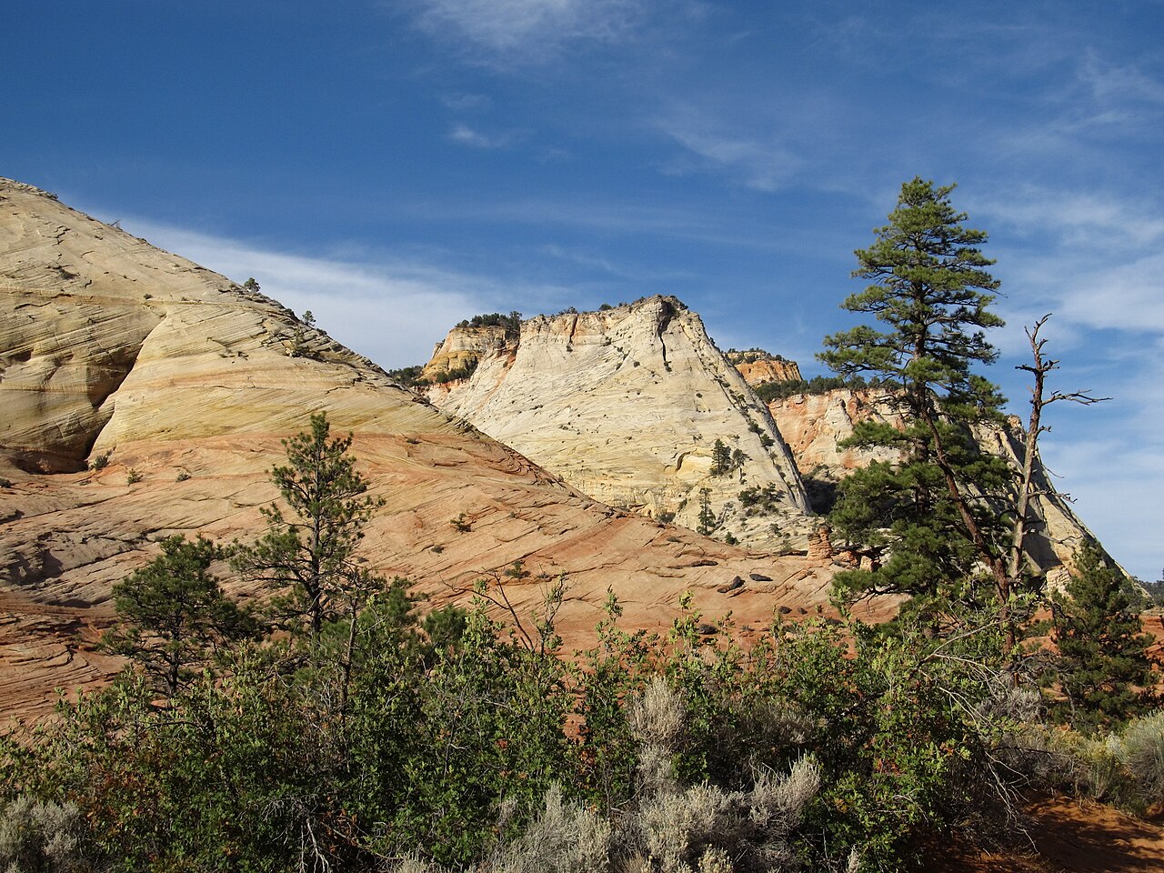
Out of the tunnel, you’re in a different world. The tall canyon walls give way to swirling, cross-bedded slickrock domes in pale cream and orange, with pinyon pines and junipers scattered between them. Watch for desert bighorn sheep, which often wander right by the road. Just past the tunnel is the Canyon Overlook trailhead, and a few miles on is Checkerboard Mesa (more on both below). Only park in paved pullouts and designated spots.
4. Leave Zion at the East Entrance
UT-9 leaves the park at the east entrance and continues to Mount Carmel Junction, where it meets US-89. Turn left (north) toward Bryce.
5. Head North on US-89
US-89 is the easy, relaxing part of the drive. It follows a long green valley past small towns like Orderville, Glendale and Hatch, with ranches, orchards and forested hills. This is where you’ll find gas, snacks and diners, so it’s a good place for a break. Services are thinner once you turn toward Bryce.
6. Turn East on Scenic Byway 12
A few miles south of Panguitch, turn right (east) onto UT-12. This is the start of Scenic Byway 12, a 122-mile road that eventually runs all the way past Escalante and Boulder to Capitol Reef. You’ll only drive the first few miles today, but they’re spectacular.
7. Drive Through Red Canyon
Almost immediately, the road enters Red Canyon in Dixie National Forest, and the color jumps. Bright red-orange hoodoos and cliffs rise between the pines, and the highway passes right through two arches tunneled into fins of red rock. These tunnels have welcomed visitors since 1925, when a caravan of more than 300 cars drove through them to celebrate the opening of what would become Bryce Canyon National Park. Red Canyon is your first taste of hoodoo country. Stop here (see below).
8. Turn South on UT-63 Into Bryce Canyon
After Red Canyon, the road climbs onto the plateau. Turn right (south) onto UT-63, which takes you through Bryce Canyon City, past hotels and the shuttle station, and into the park. The visitor center is about a mile past the park boundary, at nearly 8,000 feet, about 4,000 feet higher than where you started in Zion Canyon.
2026 Rules for RVs and Large Vehicles
This is the most important update for anyone driving between the parks in 2026 and beyond. Since June 7, 2026, large vehicles are no longer allowed on the Zion-Mount Carmel Highway between Canyon Junction and the east entrance. The old system of paying for a one-way tunnel escort is gone, so ignore older guides that mention it.
You can’t drive the tunnel road if your vehicle is larger than any of these:
| Limit | Maximum |
|---|---|
| Length (single vehicle) | 35 ft 9 in |
| Width | 7 ft 10 in |
| Height | 11 ft 4 in |
| Weight | 50,000 lb |
| Combined vehicles (truck + trailer) | 50 ft overall, and no more than 26 ft from hitch to rear axle |
The park says these limits come from safety studies showing larger vehicles can’t stay in their lane on the curves or pass through the historic tunnel in a single lane, and that some exceed the weight limits of the old bridges. Many big motorhomes, buses and trucks with travel trailers will be over at least one limit.
What to do if you’re over: Measure your rig before you go, including roof racks, AC units, ladders and oversized tires. If you’re over any limit, take an alternate route around the park. From Springdale, the most common one heads west to Interstate 15, north to Utah Highway 20, east over the mountains to US-89, then south to UT-12 and Bryce. The park says alternate routes to Bryce and other “Grand Circle” destinations add roughly 10 to 45 minutes of driving, since the mileage is longer but the roads are faster than the slow tunnel highway. Large vehicles can still visit Zion Canyon from the south entrance in certain situations, such as parking in the large-vehicle lot or staying at the campgrounds.
Best Stops Between Zion and Bryce Canyon
| Stop | Priority | Time Needed |
|---|---|---|
| Red Canyon | Must-do | 20–60 min |
| Canyon Overlook Trail | High (if you can park) | 1–1.5 hrs |
| Checkerboard Mesa | High | 10–20 min |
| East Zion pullouts | Optional | 10–30 min |
| Lunch or gas on US-89 | Practical | 30–60 min |
| Coral Pink Sand Dunes | Optional detour | 1.5–2 hrs extra |
Canyon Overlook Trail
Distance: 1 mile round trip · Climb: about 160 feet · Time: about 1 hour
Just east of the tunnel, this short trail hugs the cliffs on ledges and steps and ends at a viewpoint looking straight down Pine Creek Canyon into lower Zion Canyon, right above the switchbacks you just drove. It’s one of the best views in Zion for so little effort. The catch is parking: the lot is tiny and fills early. If there’s no legal spot, keep driving. Never park on the road or the vegetation. There are drop-offs on the trail, so keep kids close.
Checkerboard Mesa
Near the east entrance, this huge, pale sandstone dome is covered in a crisscross pattern of lines, made by ancient sand dunes (the horizontal lines) and freeze-thaw cracking (the vertical ones). It’s a roadside stop with a pullout, so there’s no hike needed. Take a few photos and keep going. It’s the perfect quick break.
Red Canyon
If you make only one stop between Zion and Bryce, make it Red Canyon. It’s right on the route, so there’s no detour, and the bright red rock is even more vivid than Bryce’s. Pull over to photograph the arches over the highway, stop at the seasonal visitor center for maps, or stretch your legs on a short trail. The Pink Ledges Trail by the visitor center is an easy loop of about a mile through red hoodoos, and the paved bike path that runs from Red Canyon all the way into Bryce is perfect if you’ve brought bikes. Keep it short, though. Save your hiking legs for Bryce.
Optional Detour: Coral Pink Sand Dunes
If you have extra time, Coral Pink Sand Dunes State Park is about 25 minutes south of Mount Carmel Junction. Its salmon-colored dunes are fun for kids, who can rent sandboards to slide down them. It adds an hour or two to the day, so it’s best on a relaxed transfer day.
Road Trip Plans for the Drive Day
Quick Version (About 3 Hours)
Leave Zion, drive the switchbacks and tunnel, stop at Checkerboard Mesa, head north on US-89, take a short photo stop in Red Canyon, and arrive at Bryce. No hikes, no detours and a quick lunch.
Half-Day Version (About 5 Hours)
8:00 a.m. Leave Springdale.
8:30 a.m. Canyon Overlook Trail, if there’s parking.
9:45 a.m. Checkerboard Mesa and East Zion pullouts.
10:30 a.m. Leave the park and head north on US-89.
Noon. Lunch along US-89.
1:15 p.m. Red Canyon, with photos and a short walk.
2:15 p.m. Arrive at Bryce Canyon visitor center, then start exploring the amphitheater.
Full Scenic Day
If you aren’t planning to hike at Bryce until the next morning, make the drive the day’s main event. Take your time at Canyon Overlook and in East Zion, add Coral Pink Sand Dunes, have a long lunch, walk in Red Canyon, check in at Bryce in late afternoon, and finish with evening light at the amphitheater.
What to Do When You Arrive at Bryce
Arriving before noon: Stop at the visitor center, then start your Bryce plans. You could even fit in the Queen’s Garden and Navajo Loop. Arriving mid-afternoon: See the main amphitheater viewpoints and save the big hike for tomorrow morning. Arriving near sunset: Head straight for Inspiration Point or Paria View for the evening light. Our guide to Bryce Canyon viewpoints explains which overlook is best at each time of day.
Zion and Bryce Canyon Itineraries
Can You See Zion and Bryce in One Day?
Technically, yes. Practically, it’s not a great idea. You’d spend four hours in the car and get only a rushed taste of each park. Each one deserves at least one full day. If you only have one day, pick one park and do it well.
How Many Days Do You Need for Zion and Bryce?
Three days is the minimum, four is ideal for most first-timers, and five or six is great for keen hikers.
| Day | 3 Days | 4 Days | 5 Days |
|---|---|---|---|
| 1 | Zion Canyon | Zion Canyon | Zion Canyon |
| 2 | Zion morning, drive to Bryce, Bryce sunset | Big Zion hike | Big Zion hike |
| 3 | Full Bryce day | Scenic drive day, Bryce sunset | Scenic drive day, Bryce sunset |
| 4 | Full Bryce day | Full Bryce day | |
| 5 | Big Bryce hike, or continue to Capitol Reef |
For your Zion days, follow our Zion National Park itinerary and see our guide to things to do in Zion National Park, which covers the shuttle, The Narrows, Angels Landing and more. For your Bryce days, our Bryce Canyon itinerary has hour-by-hour plans. The classic first hike there is the Queen’s Garden Trail combined with the Navajo Loop Trail.
Can You Day-Trip to Bryce From Zion?
You can, but it’s a long day with about four hours of driving. Leave early, drive straight to Bryce, see the amphitheater, hike the Queen’s Garden and Navajo Loop, have lunch, visit a few viewpoints, and head back before dark. Skip the stops on the way. Staying at least one night near Bryce is much more enjoyable, and it lets you see the hoodoos at sunrise, when they’re at their best.
Shuttles: What You Need to Know
This confuses a lot of people. Zion’s shuttle season doesn’t stop you from driving to Bryce. The shuttle only replaces private cars on the Zion Canyon Scenic Drive, the dead-end road up the main canyon. The Zion-Mount Carmel Highway is a separate road, and it stays open to cars (within the size limits) all year, apart from temporary closures for weather, rockfall or road work.
Neither park’s shuttle goes between the parks, and there’s no public transportation from Zion to Bryce. You’ll need a car or a guided tour.
Bryce has its own free shuttle, which ran April 3 to October 18 in 2026, with buses about every 15 minutes around the amphitheater. If you arrive during shuttle season, park at the shuttle station in Bryce Canyon City or near the visitor center instead of chasing spots at the busy viewpoints.
Weather, Winter Driving and the Best Time to Go
Why Zion and Bryce Feel So Different
It comes down to elevation. Zion Canyon sits around 4,000 feet, and Bryce sits around 8,000 to 9,000 feet. That makes Bryce often 15 to 20 degrees cooler. A T-shirt afternoon in Zion can be followed by a jacket evening at Bryce, and in spring and fall, a sunny morning in Springdale can become a snowy afternoon at Bryce. Pack for both parks, not one “southern Utah” forecast.
Best Time for the Road Trip
May, June, September and early October are the best months. Zion isn’t yet (or no longer) scorching, Bryce’s trails are free of snow, and the roads are clear. July and August work too, but expect 100°F heat in Zion and afternoon thunderstorms at Bryce, so hike early in both. Winter is beautiful but turns this into a weather-dependent drive. For month-by-month details, see our guides to the best time to visit Zion National Park and the best time to visit Bryce Canyon National Park.
Driving From Zion to Bryce in Winter
In winter, the drive climbs from mild weather into real snow country. The Zion-Mount Carmel Highway can close temporarily for snow, ice or rockfall, and Bryce gets heavy snow from November through March. Before you set off, check current conditions for both parks, the Utah state road reports and the forecast for Bryce itself, not just Springdale. Make sure your rental car has decent tires, and check your rental agreement’s rules on snow chains. Drive in daylight, and give plows time after a storm. For temperatures and snow by month, see Bryce Canyon weather by month.
Practical Tips for the Drive
Is the Drive Scary?
Most drivers find it fine. The only tricky part is the Zion switchbacks and tunnel: tight curves, drop-offs and a long dark tunnel, but at slow speeds and with guardrails. Take it slow, keep a safe gap, and let faster drivers pass at pullouts. The rest of the drive is easy, open highway.
Gas, Food and Cell Service
Fill up in Springdale before you leave. There’s no gas inside Zion. You’ll find more gas stations and simple diners along US-89 and near Mount Carmel Junction, plus more choices in Panguitch, just off the route. For a quick drive, packing a lunch is easiest. Cell service drops out in parts of East Zion and along the route, so download offline maps before you go.
Entrance Fees
Even if you’re just driving through Zion on UT-9, you’ll pay the park entrance fee. In 2026, both Zion and Bryce charge $35 per private vehicle, good for seven days. Non-U.S. residents aged 16 and older also pay an extra $100 per person at each park, unless they have the $250 nonresident annual pass. If you’re visiting both parks, an annual America the Beautiful pass usually pays for itself, especially for international visitors.
What to Keep Handy in the Car
Water, snacks, sunscreen, sunglasses, a warm layer for Bryce, a rain jacket in summer, hiking shoes for Canyon Overlook and Red Canyon, your park pass, a phone charger and offline maps. In winter, add warm clothes, a blanket and extra water in case of road delays.
Zion to Bryce With Kids
The short drive makes this a great family road trip. Keep stops simple: Checkerboard Mesa, lunch, Red Canyon, and a Bryce viewpoint when you arrive. With small kids, skip Canyon Overlook if parking is stressful or the drop-offs worry you. Coral Pink Sand Dunes is a fun bonus for kids if you have time. Use the drive as a rest day between two active park days. See our guide to Bryce Canyon with kids for easy walks once you arrive.
Zion to Bryce for Photographers
You can shoot three very different landscapes in a day: Zion’s canyon walls in the morning, East Zion’s slickrock and Red Canyon in the afternoon, and Bryce’s hoodoos at sunset. The only risk is lingering too long on the way and missing the evening light at Bryce, so keep an eye on the clock.
Bryce to Zion: Driving in Reverse
Everything here works in reverse: UT-63 north, UT-12 west through Red Canyon, US-89 south, then UT-9 west through the east entrance, the tunnel and down the switchbacks into Zion Canyon. Neither direction is better. Driving Zion to Bryce takes you from giant cliffs up to hoodoos, while Bryce to Zion saves the dramatic plunge into Zion Canyon for last. If you’re flying into Las Vegas, starting at Zion usually makes more sense. If you’re coming from Capitol Reef or Salt Lake City, start at Bryce.
Continuing Your Utah Road Trip
From Bryce, keep going east on Scenic Byway 12 through Escalante and Boulder to Capitol Reef, one of the most beautiful drives in the country. Then continue to Hanksville, Goblin Valley and the badlands. Our Hanksville, Utah itinerary picks up from there.
Zion vs Bryce: Which Is Better?
They’re too different to compare, and that’s exactly why they belong on the same trip. In Zion you stand at the bottom of a canyon looking up at 2,000-foot walls, with river hikes and big climbs. At Bryce you stand on a rim looking down on thousands of hoodoos, with short trails and huge views close to the road. They’re so close that you don’t have to choose.
Common Zion to Bryce Road Trip Mistakes
- Budgeting exactly two hours. With even a couple of stops, plan on three or more.
- Ignoring the 2026 vehicle limits. Measure your RV or trailer before you go.
- Thinking Zion’s shuttle blocks the drive. It doesn’t. UT-9 stays open to cars.
- Counting on Canyon Overlook parking. Have a backup plan.
- Skipping Red Canyon because it isn’t a national park.
- Checking only Zion’s weather. Bryce is 4,000 feet higher.
- Trying to fully see both parks in one day.
Related Guides
Keep planning with these related guides:
- Las Vegas to Zion National Park
- Best Hikes in Bryce Canyon National Park
- Closest Airport to Zion National Park
- Zion National Park Map
Zion to Bryce Canyon: FAQs
How far is Zion from Bryce Canyon?
About 85 to 90 miles on the usual route through Zion’s east entrance.
How long is the drive from Zion to Bryce Canyon?
About 2 hours without stops, or 3 to 5 hours with scenic stops, a short hike and lunch.
What is the best route from Zion to Bryce Canyon?
UT-9 east through Zion and the tunnel, US-89 north, UT-12 east through Red Canyon, then UT-63 south into Bryce.
Can RVs drive from Zion to Bryce through the tunnel?
Only if they meet Zion’s size limits: 35 ft 9 in long, 7 ft 10 in wide, 11 ft 4 in high and 50,000 lb, or 50 ft overall for combinations. Since June 7, 2026, larger vehicles must take an alternate route.
What is there to see between Zion and Bryce?
The Zion switchbacks and tunnel, the Canyon Overlook Trail, Checkerboard Mesa, East Zion’s slickrock, and Red Canyon with its highway arches. Coral Pink Sand Dunes is a worthwhile detour.
Can you drive from Zion to Bryce during shuttle season?
Yes. The shuttle only affects the Zion Canyon Scenic Drive. The Zion-Mount Carmel Highway to Bryce stays open to cars that meet the size limits.
Is there public transportation from Zion to Bryce?
No. You’ll need your own car, a rental or a guided tour.
Do you have to pay to drive through Zion to Bryce?
Yes. The route passes through Zion, so you need a park pass: $35 per vehicle for seven days in 2026, or an annual pass.
How many days do you need for Zion and Bryce?
At least three, but four is better: two days in Zion, a scenic drive day, and a full day at Bryce.
Is it better to go Zion to Bryce or Bryce to Zion?
Both work. Choose based on where you’re flying in or where you’re heading next. From Las Vegas, start at Zion. From Salt Lake City or Capitol Reef, start at Bryce.
Make the Drive Part of the Trip
The drive from Zion to Bryce Canyon isn’t hard, and that’s the point. In less than 100 miles you go from the bottom of a sandstone canyon, up a wall of switchbacks, through a historic mile-long tunnel, across slickrock domes and ranch valleys, under red rock arches and onto a plateau full of hoodoos. It’s one of the best short road trips in the American West.
So don’t treat it as dead time between two parks. Give it a few extra hours, stop at Checkerboard Mesa and Red Canyon, and roll into Bryce with enough time to stand above the amphitheater as the evening light hits the hoodoos. For your first day there, start with our guide to the best things to do in Bryce Canyon National Park.