
At first glance, a Zion National Park map looks simple: one famous canyon, one visitor center, a few shuttle stops and a highway across the middle. Then you start planning hikes, and things get confusing.
Angels Landing and The Narrows are in Zion Canyon, but you usually can’t drive there. Canyon Overlook is on the other side of a mile-long tunnel. Kolob Canyons is part of Zion too, yet it’s about an hour’s drive away with its own entrance off the interstate. And the shuttle in Springdale isn’t the same as the shuttle in the park.
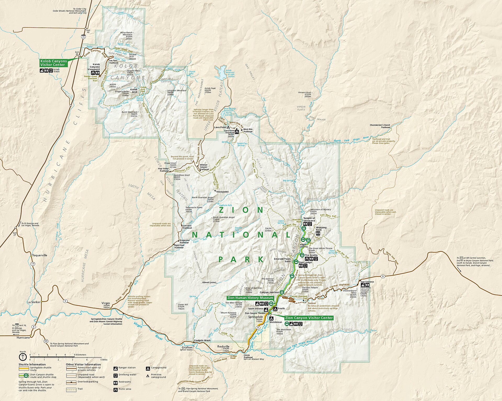
This guide explains the Zion National Park map in plain terms: the main areas, the entrances, every shuttle stop and what it’s for, where the big trailheads are, and how to group them so you don’t waste half your day going back and forth.
⚠️ October 2026 map update: The Zion-Mount Carmel Highway (Route 9) is closed between Canyon Junction and the East Entrance after a large rockfall on September 30, 2026, with no reopening date yet. Right now you can’t drive through the tunnel to East Zion, Canyon Overlook or Checkerboard Mesa from Zion Canyon, and you can’t use the East Entrance to reach the main canyon. Zion Canyon, the shuttle, Springdale, Kolob Canyons and Kolob Terrace are open. Check the park’s alerts before you travel.
How Is Zion National Park Laid Out?
Zion isn’t one loop road. It’s several separate areas. Zion Canyon, in the south of the park next to Springdale, holds most famous sights and is reached by shuttle for most of the year. Route 9 crosses the park east through a tunnel to East Zion and the East Entrance. Kolob Canyons sits in the northwest, about 40 miles and an hour’s drive away, off I-15 Exit 40. Kolob Terrace is a high, quiet area reached by road from the town of Virgin.
Zion Map at a Glance
| Area | Where on the Map | Best For | How You Get There |
|---|---|---|---|
| Zion Canyon | South-central | Angels Landing, The Narrows, Emerald Pools | Free shuttle for most of the year |
| Springdale and South Entrance | Southern edge | Hotels, food, parking, gear rental | Car, Springdale shuttle, on foot |
| Zion-Mount Carmel Highway and East Zion | East of Zion Canyon | Tunnel, Canyon Overlook, Checkerboard Mesa | Your own car (currently closed) |
| Kolob Canyons | Northwest | Quiet scenic drive, Taylor Creek | I-15 Exit 40 |
| Kolob Terrace | West-central, high plateau | Northgate Peaks, Lava Point, wilderness | Kolob Terrace Road from Virgin |
In This Guide
- Zion’s entrances
- Zion Canyon map and shuttle stops
- How the two shuttles work
- The Zion-Mount Carmel Highway and East Zion
- Kolob Canyons and Kolob Terrace
- Where the main trailheads are
- Driving distances and times
- Using the map to plan 1, 2 or 3 days
- FAQs
Zion National Park Entrances
Zion has three main ways in for most visitors: two on Route 9 for the main park, and a separate one for Kolob Canyons. You pay the entrance fee ($35 per vehicle, valid for 7 days, in 2026) once and can use it at any entrance.
| Entrance | Where It Is | Use It If… |
|---|---|---|
| South Entrance | North end of Springdale, next to the Zion Canyon Visitor Center | You’re coming from Las Vegas, St. George or I-15, or staying in Springdale. Most first-timers use this one. |
| Pedestrian/bike entrance | Footbridge from Zion Canyon Village in Springdale | You parked in town or rode the Springdale shuttle |
| East Entrance | Route 9, about 13 miles west of Mount Carmel Junction | You’re coming from Bryce Canyon, Kanab or the Grand Canyon North Rim (currently can’t reach Zion Canyon this way) |
| Kolob Canyons entrance | I-15 Exit 40, about 17 miles south of Cedar City | You’re visiting the quiet northwest section of the park |
South or East Entrance? If you’re staying in Springdale or focusing on Zion Canyon, use the South Entrance. In normal times, the East Entrance is the natural choice when arriving from Bryce, Kanab or the North Rim, since the drive through East Zion and the tunnel is one of the most scenic entries to any national park. While the highway is closed, everyone heading to Zion Canyon has to come in through Springdale. From Bryce, that means going around via Highway 20 and I-15, about 2.5 to 3 hours. See our Zion to Bryce Canyon road trip guide for routes.
Where Is Springdale on the Map?
Springdale is the small town stretched along Route 9 right outside the South Entrance. It’s Zion’s gateway: hotels, restaurants, grocery stores, gear rental for The Narrows, and paid parking. At its north end is Zion Canyon Village, where a footbridge (the pedestrian entrance) crosses the river into the park, just steps from the visitor center.
Staying in Springdale is the easiest way to use the park map well, since you can leave your car at the hotel and use the shuttles. See our guide to hotels near Zion National Park for the best areas.
Zion Canyon Map: The Area That Matters Most
Zion Canyon is the long, deep canyon carved by the North Fork of the Virgin River, in the southern part of the park. One road runs up it: the Zion Canyon Scenic Drive, about 6 miles from Canyon Junction to the Temple of Sinawava, where the canyon narrows and the road ends. If you have only one day, this is the part of the map that matters.
The key rule: during shuttle season (March 7 to November 28, and December 26 to January 2 in 2026), you can’t drive your own car on the Zion Canyon Scenic Drive. That includes before the first shuttle and after the last one. You ride the free shuttle, bike it, or walk. In the off-season (November 29 to December 25, and early January to early March), you can usually drive it yourself, but parking at trailheads is limited and the park may close the road when lots fill.
Zion Canyon Shuttle Stops, One by One
The Zion Canyon Line (look for green signs) has 9 stops. Here’s what each one is for:
| Stop | Name | Use It For |
|---|---|---|
| 1 | Zion Canyon Visitor Center | Main hub: parking, maps, rangers, restrooms, water, Pa’rus Trail, Watchman Trail (currently closed), campgrounds |
| 2 | Zion Human History Museum | Museum, park film, views, restrooms (spring to late November) |
| 3 | Canyon Junction | North end of the Pa’rus Trail; classic Watchman sunset view from the bridge |
| 4 | Court of the Patriarchs | Short paved path to a view of three huge peaks |
| 5 | Zion Lodge | Emerald Pools, food, restrooms, lawn, free WiFi, horseback rides |
| 6 | The Grotto | Angels Landing, Scout Lookout, West Rim Trail, Kayenta Trail, picnic area |
| 7 | Weeping Rock | Weeping Rock area; the routes to Hidden Canyon and Observation Point from here remain closed after a major rockfall |
| 8 | Big Bend | Views of the Great White Throne and Angels Landing, rock climbers on the walls |
| 9 | Temple of Sinawava | Riverside Walk and The Narrows, restrooms, water. End of the line |
Good to know: you can’t board a shuttle heading up-canyon at stops 2 and 3. Those are mainly drop-off and down-canyon stops. Everyone has to get off at the Temple of Sinawava and at the visitor center.
The five stops most first-timers need: 1 (Visitor Center), 5 (Zion Lodge), 6 (The Grotto), 9 (Temple of Sinawava), and 4 or 8 for a quick scenic stop on the way.
How the Zion Shuttles Work
There are two separate shuttle systems, and mixing them up is one of the most common first-day mistakes.
| Springdale Line | Zion Canyon Line | |
|---|---|---|
| Sign color | Orange | Green |
| Where it runs | Through Springdale, 9 stops | Inside the park, 9 stops |
| Ends at | Zion Canyon Village (pedestrian entrance) | Temple of Sinawava |
| How often | Every 10 to 15 minutes | Every 5 to 10 minutes |
| Cost | Free | Free, no ticket or reservation |
How to connect them: ride the Springdale Line to Zion Canyon Village (its stop 1), walk over the pedestrian footbridge into the park (show your pass or pay the fee there), then walk a few minutes to the visitor center and board the Zion Canyon Line. Allow 15 to 20 minutes for the transfer on busy mornings.
How Long Does the Shuttle Take?
About 45 minutes from the visitor center to the Temple of Sinawava, so a full round trip is about an hour and a half before you get off anywhere. Zion Lodge is roughly 20 to 25 minutes in, and The Grotto just a few minutes beyond. Build this into every plan, especially for The Narrows, at the far end of the line.
2026 Shuttle Schedule
| Dates | First Bus From Visitor Center | Last Bus From Visitor Center | Last Bus Out of Temple of Sinawava |
|---|---|---|---|
| Mar 7 – May 16 | 7:00 a.m. | 6:00 p.m. | 7:15 p.m. |
| May 17 – Sep 12 | 7:00 a.m. | 7:00 p.m. | 8:15 p.m. |
| Sep 13 – Oct 24 | 7:00 a.m. | 6:00 p.m. | 7:15 p.m. |
| Oct 25 – Nov 28 | 7:00 a.m. | 5:00 p.m. | 6:15 p.m. |
| Nov 29 – Dec 25 | No service (drive your own car) | ||
| Dec 26 – Jan 2 | 8:00 a.m. | 4:30 p.m. | 5:45 p.m. |
The Springdale Line starts at 8 a.m. from the south end of town (Hotel De Novo, its stop 9) for most of the fall schedule. Don’t wait for the last bus out of the canyon. If it’s full or you miss it, the park warns you could face a walk of about 9 miles back to the visitor center.
Shuttle Rules
- No eating or smoking on the bus. Capped water bottles are fine.
- No pets on the shuttle.
- Strollers are allowed; large ones may need to be folded.
- Each bus carries up to three regular bikes on the front rack. E-bikes aren’t allowed on the racks or on board.
Parking Strategy
The map doesn’t show you the parking problem. The visitor center lot often fills early, by about 9 a.m. in summer and on busy weekends. Plan A: arrive early and park at the visitor center. Plan B: park in Springdale (most parking there is paid), ride the free Springdale Line to Zion Canyon Village and walk in. Don’t spend an hour circling for a space. Even better, stay in Springdale and leave the car at your hotel.
Biking the Scenic Drive
You can bike the Zion Canyon Scenic Drive even during shuttle season. Ride the Pa’rus Trail from the visitor center to Canyon Junction, then follow the road up the canyon, pulling over to let shuttles pass. Bikes and e-bikes can be rented in Springdale. It’s a great way to stop wherever you want.
The Zion-Mount Carmel Highway and East Zion
Route 9, the Zion-Mount Carmel Highway, is a different road from the Zion Canyon Scenic Drive. From Canyon Junction it climbs a series of tight switchbacks, passes through the 1.1-mile Zion-Mount Carmel Tunnel (completed in 1930), then crosses the high slickrock country of East Zion to the East Entrance. In normal times, you can drive it in your own car even during shuttle season.
East Zion feels completely different from the canyon below. It’s more open, with rounded, cross-bedded sandstone domes. The main stops are:
- Canyon Overlook Trail, just past the east end of the tunnel: a 1-mile round trip to a huge view down Zion Canyon. It isn’t served by the Zion Canyon shuttle, and parking is tiny.
- Checkerboard Mesa, a roadside viewpoint near the East Entrance, with its famous crisscrossed rock face.
- Bighorn sheep, often seen on the slickrock along the road.
Large vehicles: big RVs, trailers and buses face strict size limits on this road and through the tunnel, and the park currently says large vehicles aren’t allowed between Canyon Junction and the East Entrance and must reroute. Check the park’s large vehicle page before you go.
Right now: this whole stretch is closed after the September 30, 2026 rockfall. Plan East Zion as a separate trip from the east side once it reopens.
Kolob Canyons and Kolob Terrace
Where Is Kolob Canyons?
Kolob Canyons is in the northwest corner of Zion, about 40 miles north of Zion Canyon. There’s no road through the park between them. You drive out to I-15, and it takes about an hour each way from Springdale. The entrance is at I-15 Exit 40, about 17 miles south of Cedar City, with its own small visitor center.
From there, the 5-mile Kolob Canyons Road climbs past deep red “finger canyons” to the short Timber Creek Overlook walk at the end. The Taylor Creek Trail (about 5 miles round trip) leads to the huge Double Arch Alcove, and La Verkin Creek leads into the backcountry toward Kolob Arch. It’s far quieter than Zion Canyon, with no shuttle and no crowds. The road sometimes closes in winter storms.
| Zion Canyon | Kolob Canyons | |
|---|---|---|
| Location | South, by Springdale | Northwest, off I-15 |
| Getting around | Shuttle most of the year | Your own car |
| Crowds | Busy | Quiet |
| Main hikes | Angels Landing, The Narrows, Emerald Pools | Taylor Creek, Timber Creek Overlook |
| Best for | First visits | A third day, or a stop on the I-15 drive |
What Is Kolob Terrace?
People often confuse it with Kolob Canyons, but it’s a different area. The Kolob Terrace Road starts in the small town of Virgin, about 15 miles west of Springdale, and climbs north onto a high, forested plateau. It leads to the easy Northgate Peaks trail, wilderness trailheads (including the route to The Subway, which needs a permit) and Lava Point, one of the highest points in the park. It’s cooler than the canyon in summer, but the upper road usually closes for several months in winter due to snow.
Where Are the Main Trailheads?
| Hike | Area | Trailhead | How to Get There |
|---|---|---|---|
| Pa’rus Trail | Lower canyon | Visitor center / Canyon Junction | Walk from the visitor center |
| Emerald Pools | Zion Canyon | Zion Lodge | Shuttle stop 5 |
| Angels Landing and Scout Lookout | Zion Canyon | The Grotto | Shuttle stop 6 |
| Kayenta Trail | Zion Canyon | The Grotto | Shuttle stop 6 |
| Riverside Walk and The Narrows | Zion Canyon | Temple of Sinawava | Shuttle stop 9 |
| Canyon Overlook | East Zion | East end of the tunnel | Own car (road currently closed) |
| Observation Point | East rim | East Mesa Trailhead, outside the park | High-clearance car via the east side |
| Taylor Creek, Timber Creek | Kolob Canyons | Kolob Canyons Road | Own car via I-15 Exit 40 |
| Northgate Peaks | Kolob Terrace | Wildcat Canyon Trailhead | Own car via Kolob Terrace Road |
Watch out for old maps. Many older maps and guides still show Observation Point and Hidden Canyon reached from Weeping Rock in Zion Canyon. Those routes have been closed for years after a huge rockfall. Today, Observation Point is reached only from the East Mesa Trailhead on the east side. The Watchman Trail near the visitor center is also currently closed for repairs. Always cross-check with the park’s current alerts.
For details on each hike, see our guides to Angels Landing, The Narrows and Emerald Pools, or compare them all in our guide to the best hikes in Zion National Park.
Zion Driving Distances and Times
| From Zion Canyon Visitor Center To | Approx. Distance | Approx. Drive Time |
|---|---|---|
| Springdale (center of town) | 1 to 2 miles | 5 minutes |
| Kolob Canyons (I-15 Exit 40) | About 40 miles | About 1 hour |
| Kolob Terrace (Northgate Peaks area) | About 35 miles | About 1 hour |
| St. George | About 45 miles | About 1 hour |
| Las Vegas | About 160 miles | 2.5 to 3 hours |
| Bryce Canyon (normal route via the tunnel) | About 85 miles | About 2 hours |
| Bryce Canyon (current detour via I-15) | About 150 miles | 2.5 to 3 hours |
| Kanab (normal route via East Entrance) | About 40 miles | About 1 hour |
Times are rough and don’t include traffic, shuttle lines or stops. Remember that Utah is an hour ahead of Las Vegas. Driving in from Nevada? See our Las Vegas to Zion National Park road trip guide.
Which Zion Map Should You Use?
Use two maps: the official park map for the big picture (where each area is) and the Zion Canyon shuttle map for your actual day (how to get from the visitor center to your trailhead). Both are free at the visitor centers and entrance stations, and the park posts downloadable versions on its maps and publications pages, including the seasonal park information guide, which has the current shuttle schedule and trail list.
Official map or Google Maps? Use both. The official map is best for trailheads, shuttle stops, campgrounds and closures. Google Maps or another app is best for driving from your hotel, finding gas and food, and estimating road times. But navigation apps don’t understand the shuttle-only rule on the scenic drive, and they may still route you through a closed road. For anything inside the park, trust the official map and current alerts.
Download it before you go. Cell service is patchy in Zion Canyon. Before you enter the park, download the park map and shuttle map, screenshot your plan, and save any permits offline. Zion Lodge and the visitor center have free WiFi if you get stuck.
Using the Zion Map to Plan Your Days
The secret is to group activities by area, so each day stays in one part of the map.
One Day
Ignore most of the map and stay in Zion Canyon. Two classic routes:
- Visitor Center → The Grotto (Angels Landing or Scout Lookout) → Zion Lodge (lunch, Emerald Pools) → Visitor Center → Pa’rus Trail at sunset.
- Visitor Center → Temple of Sinawava (Riverside Walk, The Narrows) → Zion Lodge (lunch) → Court of the Patriarchs → Visitor Center.
Two Days
Day 1 on the Grotto/Lodge end of the canyon (big climb plus Emerald Pools), Day 2 at the Temple of Sinawava end (The Narrows and Riverside Walk). Once the highway reopens, East Zion and Canyon Overlook make a great half day too.
Three Days
Add Kolob Canyons or Kolob Terrace as a separate day by car. That’s when the full park map really becomes useful. For hour-by-hour plans, see our Zion National Park itinerary. Traveling with children? Our guide to Zion National Park with kids focuses on the easiest parts of the map: the visitor center, Pa’rus Trail, Zion Lodge and the Riverside Walk.
Common Zion Map Mistakes
- Thinking Zion is one loop road. It’s several separate areas.
- Assuming Kolob Canyons is next to Zion Canyon. It’s an hour away.
- Expecting the shuttle to go to Canyon Overlook. It doesn’t.
- Trying to drive the scenic drive before the first bus. Not allowed in shuttle season.
- Confusing the Springdale shuttle with the park shuttle.
- Using an old map for Observation Point or Hidden Canyon.
- Trusting a navigation app during road closures.
- Cramming Kolob, The Narrows and East Zion into one day.
Related Guides
Still putting your plans together? You might also find these useful:
- Closest Airport to Zion National Park
- Zion National Park Weather by Month
- Best Time to Visit Zion National Park
Zion National Park Map: FAQs
Where can I get an official Zion National Park map?
Free paper maps are handed out at the entrance stations and visitor centers, and the park posts downloadable maps, an interactive map and the seasonal information guide on its website.
Where is Zion Canyon on the map?
In the southern part of the park, right next to Springdale and the South Entrance.
How many entrances does Zion have?
The main ones are the South Entrance (Springdale), the East Entrance on Route 9, and the separate Kolob Canyons entrance at I-15 Exit 40. There’s also a pedestrian entrance from Springdale.
How many shuttle stops are there in Zion?
Nine on the Zion Canyon Line, from the visitor center (stop 1) to the Temple of Sinawava (stop 9), plus nine more on the separate Springdale Line in town.
Which shuttle stop is Angels Landing?
The Grotto, stop 6.
Which shuttle stop is The Narrows?
The Temple of Sinawava, stop 9, the last stop. Walk the Riverside Walk about a mile to the river.
Which shuttle stop is Emerald Pools?
Zion Lodge, stop 5. You can also reach the pools from The Grotto, stop 6, on the Kayenta Trail.
Does the Zion shuttle go to Canyon Overlook?
No. Canyon Overlook is on the Zion-Mount Carmel Highway past the tunnel and needs your own vehicle. That road is currently closed after a September 2026 rockfall.
Can you drive the Zion Canyon Scenic Drive?
Not during shuttle season, even before or after the buses run. You can usually drive it in the off-season, from late November to late December and from early January to early March.
How far is Kolob Canyons from Zion Canyon?
About 40 miles, or roughly an hour by car via I-15.
Is the Zion-Mount Carmel Highway open?
Not as of October 2026. It has been closed between Canyon Junction and the East Entrance since a large rockfall on September 30, 2026. Check the park’s alerts for updates.
How to Read the Zion Map the Right Way
Stop thinking of Zion as one attraction and start thinking of it as a few travel zones. Zion Canyon is the shuttle-served heart of the park. Springdale is your gateway for beds, food and parking. East Zion is the scenic drive through the tunnel. Kolob Canyons is a quiet, separate district an hour away. Kolob Terrace is the high country for wilderness lovers.
Once those pieces click, the rest of Zion is easy to plan. The best map isn’t the one with the most detail. It’s the one that shows you which places belong together on the same day. For more ideas once you’ve got your bearings, see our guide to the best things to do in Zion National Park.