
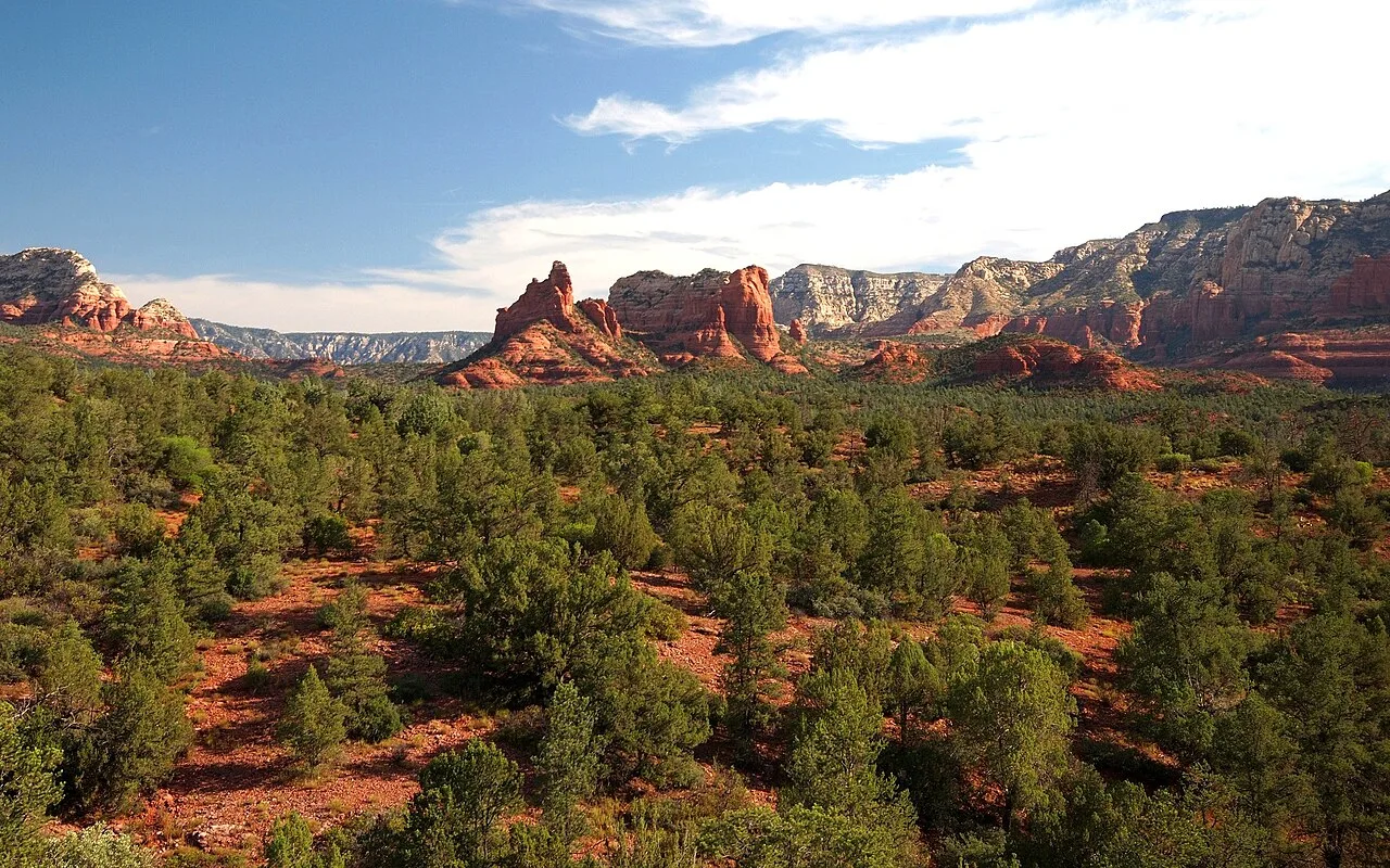
Most Sedona hikes are short, sunny and steep. Boynton Canyon is different. It starts among towering red cliffs, winds past a fancy resort, and then slips into a quiet box canyon where tall pines and oaks give you shade and the red rock walls close in on both sides.
The Boynton Canyon Trail in Sedona is one of the area’s most famous hikes for three reasons: the beautiful canyon itself, the nearby Boynton Vista vortex that draws spiritual seekers from around the world, and Subway Cave, an Instagram-famous sandstone alcove reached by an unofficial side path.
Those three are very different experiences, and many guides mix them up. This one keeps them clear. You’ll find distance, difficulty, parking and pass rules, what each section looks like, honest info about Subway Cave, the best time to go and safety tips.
Quick answer
- Distance: 6 miles round trip (Forest Service).
- Elevation gain: about 931 feet.
- Time: 4–5 hours round trip (Forest Service: about 2.5 hours one way).
- Difficulty: moderately challenging.
- Trailhead: Boynton Canyon Trailhead on Boynton Canyon Road, just outside Enchantment Resort.
- Parking: Red Rock Pass or America the Beautiful pass required. Lot fills early.
- Vortex: Boynton Vista is a short side trail near the start, not at the end of the canyon.
- Subway Cave: reached by an unofficial, unsigned path with steep slickrock. Not part of the official trail.
- Best time: spring and fall.
Boynton Canyon Trail at a Glance
| Official name | Boynton Canyon Trail #47, Coconino National Forest |
| Location | West Sedona, Arizona |
| Distance | 6 miles round trip (out and back) |
| Elevation gain | About 931 feet |
| Trailhead elevation | About 4,525 feet |
| Time | 4–5 hours |
| Difficulty | Moderately challenging |
| Area | Red Rock–Secret Mountain Wilderness area |
| Parking pass | Red Rock Pass or America the Beautiful pass |
| Sedona Shuttle | Not served |
| Best seasons | Spring and fall (winter is good too) |
Trail facts come from the Coconino National Forest.
Three Different Hikes in One Place
| Destination | What it is | Difficulty | Distance (round trip) |
|---|---|---|---|
| Boynton Canyon (main trail) | Official Trail #47 into a red rock box canyon | Moderate | 6 miles |
| Boynton Vista (vortex) | Short spur near the start to a rocky saddle and Kachina Woman rock | Short, steep, rocky | Roughly 1 mile or less from the trailhead |
| Subway Cave | Unofficial side path to a sandstone alcove | Steep slickrock at the end | Varies (usually around 5–6 miles) |
Decide which one you want before you start.
Where Is Boynton Canyon?
Boynton Canyon is in West Sedona, northwest of town, in the Coconino National Forest. The trailhead is right outside the entrance to Enchantment Resort. You don’t need to be a resort guest to hike; just use the public trailhead.
Directions
- From Sedona, drive west on SR-89A.
- Turn right (north) onto Dry Creek Road.
- At the T, turn left onto Boynton Pass Road.
- At the next T, turn right onto Boynton Canyon Road (toward Enchantment Resort).
- The trailhead parking is on the right, just before the resort gate.
The roads are paved. The drive takes about 15–20 minutes from central Sedona.
Parking and passes
- You need a Red Rock Pass (sold online and at local vendors) or an America the Beautiful pass to park.
- The lot is popular and fills early, especially on weekends and in spring and fall. Arrive early.
- Don’t park at the resort or along the road where it’s posted no parking.
- The free Sedona Shuttle does not serve Boynton Canyon, so you’ll need to drive.
How Hard Is the Boynton Canyon Trail?
The Forest Service rates it moderately challenging. The climbing is gradual, spread over 3 miles. The challenges are:
- The length: 6 miles total.
- Rocky, uneven sections and some sand.
- Sun on the first mile or so near the resort.
- A steeper, rockier final stretch at the end of the canyon.
Is it good for beginners and families?
Yes, if you can walk several miles. It’s a good choice for families with kids who like to hike, because you can turn around anywhere. The shady canyon section is especially pleasant.
Is Boynton harder than Cathedral Rock?
No. Cathedral Rock is much shorter but involves steep scrambling. Boynton is longer but mostly a walk.
Boynton Canyon Trail, Step by Step
1. The trailhead and Boynton Vista junction
From the parking lot, the trail heads north past red rock walls. Very soon you’ll reach the signed junction for Boynton Vista Trail, the spur to the vortex. (More on that below.) For the canyon, follow the signs to stay on Boynton Canyon Trail.
2. Along the resort
For the next mile or so, the trail skirts the edge of Enchantment Resort. You’ll see casitas below and red cliffs above. The trail climbs up and down along the hillside here, with more sun than the rest of the hike. Stay on the public trail.
3. Into the canyon
Past the resort, the trail drops into the canyon floor and the mood changes completely. Now you walk through a forest of pinyon pine, juniper, Arizona cypress and oak, with soaring red and white cliffs on both sides. The Forest Service describes this stretch as an easy, pleasant walk. Watch for songbirds and even whitetail deer.
4. The upper canyon
Keep going up canyon. The trees get taller and greener, and the walls close in. In fall, the oaks and other trees add yellow and orange color.
5. The end of the trail
The last part climbs more steeply over rock to a viewpoint near the head of the box canyon, where the red walls wrap around you. It’s a peaceful spot for lunch before heading back.
6. The return
Return the same way. It’s mostly gently downhill. The section near the resort can be warm in the afternoon, so bring enough water.

The Boynton Canyon Vortex (Boynton Vista)
Sedona is famous for its “vortexes,” places that many people believe have special spiritual energy. Boynton Canyon is one of the best known. The Forest Service presents this as a matter of personal belief, and it’s not a scientific claim. Either way, the views are real.
- Where: the Boynton Vista Trail branches off near the start of the Boynton Canyon Trail.
- What you’ll find: a short, steep, rocky climb to a saddle with views of the canyon, next to a tall red spire often called Kachina Woman.
- How long: it’s a short outing, typically well under an hour round trip from the junction.
Please be respectful. People come here to meditate. Don’t build rock stacks or leave offerings; they damage the area.
Subway Cave: What You Should Know
Subway Cave is a curving sandstone alcove high on the canyon wall that looks like a subway tunnel opening. It’s become one of the most photographed spots in Sedona.
- It’s not on the official trail. It’s reached by an unofficial, unsigned side path off Boynton Canyon Trail.
- The last part is steep slickrock with exposure. A slip could mean a serious fall.
- There are ancient cultural sites in this area, including fragile ruins in nearby alcoves. These are protected by federal law. Never touch, climb on or enter ruins, and never take anything.
- It gets very crowded at times, and social trails damage the desert.
If you go, use a current, reliable map, stay on the most obvious existing path, turn back if the slickrock feels unsafe, and treat the cultural sites with total respect. If you’re not comfortable with steep rock, the main canyon trail gives you plenty of beauty on its own.
Best Time to Hike Boynton Canyon
| Season | What to expect |
|---|---|
| March–May | Comfortable temperatures, wildflowers in good years, busy |
| June–August | Hot, with monsoon storms from July; start very early |
| September–November | Excellent weather and fall color in the canyon |
| December–February | Cool and quieter; shady sections can be icy after storms |
Time of day: start early to get parking and avoid heat on the sunny first mile. Morning light on the red cliffs is beautiful.
Storms: avoid the canyon during heavy rain or lightning.
What to Bring
- Water: at least 2 liters per person, more in warm weather.
- Hiking shoes with good grip.
- Snacks or lunch.
- Sun protection: hat, sunglasses, sunscreen.
- Light jacket for the shady canyon in cooler months.
- Red Rock Pass or America the Beautiful pass.
- Offline map.
Safety and Etiquette
- Stay on official trails to protect plants and cultural sites.
- Respect archaeological sites: look, don’t touch.
- Don’t build cairns or rock stacks.
- Pack out all trash.
- Dogs: allowed on a leash on national forest trails. Bring water for them.
- Turn back on slickrock if it feels unsafe.
Boynton Canyon vs. Other Sedona Hikes
| Trail | Distance | Difficulty | Best for |
|---|---|---|---|
| Boynton Canyon | 6 mi | Moderate | Long scenic walk, shade, vortex |
| Cathedral Rock | 1.1 mi | Strenuous | Short, steep scramble |
| Devils Bridge | Varies by parking | Moderate | Famous sandstone arch |
| Fay Canyon | About 2.4 mi | Easy | Short canyon walk nearby |
Frequently Asked Questions
How long is the Boynton Canyon Trail?
6 miles round trip, according to the Forest Service.
How hard is Boynton Canyon?
Moderately challenging. It’s long but mostly gradual.
How long does it take?
About 4–5 hours round trip.
Where is the Boynton Canyon vortex?
On the short Boynton Vista Trail near the start, not at the end of the canyon.
Is Subway Cave on the Boynton Canyon Trail?
No. It’s reached by an unofficial side path with steep slickrock.
Do you need a pass to park?
Yes, a Red Rock Pass or America the Beautiful pass.
Does the Sedona Shuttle go to Boynton Canyon?
No. You’ll need to drive.
Can you park at Enchantment Resort?
No. Use the public trailhead lot.
Are dogs allowed?
Yes, on a leash.
When is the best time to hike?
Spring and fall, early in the day.
Is Boynton Canyon worth it?
Yes. It’s one of the most beautiful and peaceful canyon hikes in Sedona.
Final Thoughts
Boynton Canyon gives you Sedona at its most peaceful: red cliffs, shady forest and a quiet box canyon at the end. Start early for parking, pick your goal (canyon, vortex or cave), and respect the cultural sites. Even if you only walk part of it, you’ll see why so many people call this place special.
More Sedona and Arizona hikes: Cathedral Rock Trail, Devils Bridge, the cave and pools on the Soldier Pass Trail, the easy loop around Bell Rock, Peralta Trail and the best winter hiking trails in the USA.
Official info: Coconino National Forest: Boynton Canyon Trail #47.