
Most people drive right past the Natural Bridge turnoff on their way to Badwater Basin. That’s a mistake.
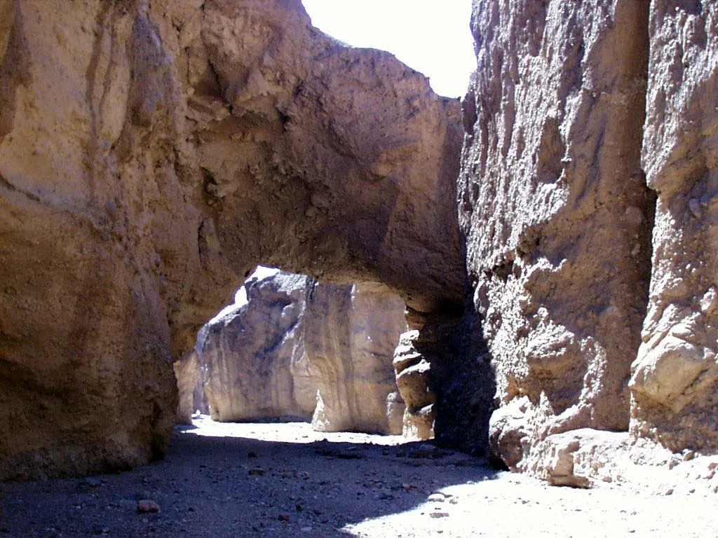
In just a few minutes of walking, a rocky canyon leads you to a giant slab of rock stretched across the canyon like a bridge, about 35 feet above your head. It’s rough, chunky and raw, nothing like the smooth red arches of Utah. And it’s one of the easiest hikes in Death Valley.
The Natural Bridge Trail in Death Valley is about 1 mile round trip, takes around 45 minutes, and is perfect if you want a short leg-stretcher with a big “wow” at the end. This guide covers everything: the dirt road, parking, what you’ll see, what’s past the bridge, the best time to go and how to stay safe.
Quick answer
- Distance: 1 mile round trip (NPS).
- Time: about 45 minutes.
- Elevation gain: 86 feet.
- Difficulty: easy, but very rocky underfoot.
- Getting there: Badwater Road, 13.5 miles south of Highway 190, then a short unpaved road to the trailhead.
- Car: most vehicles can usually make it, but ruts and washouts happen after rain.
- Facilities: vault toilet, no water.
- Best time: November to March, morning or late afternoon.
Natural Bridge Trail at a Glance
| Location | Death Valley National Park, California (off Badwater Road) |
| Trailhead | End of Natural Bridge Road, 13.5 miles south of CA-190 via Badwater Road |
| Distance | 1 mile round trip (out and back) |
| Time | About 45 minutes |
| Elevation gain | 86 feet |
| Difficulty | Easy (rocky, uneven surface) |
| Trail type | No formal trail. You follow the rocky wash up the canyon. |
| Bridge size | About 35 ft high and 35 ft thick |
| Road | Unpaved dirt road, usually fine for most cars |
| Parking | Open dirt lot, big enough for buses and RVs |
| Restroom | Vault toilet. No drinking water. |
| Dogs | Not allowed, even if carried |
| Best season | November to March |
Trail facts above come from the National Park Service.
Where Is Natural Bridge in Death Valley?
Natural Bridge sits on the east side of Death Valley, in the Black Mountains above Badwater Road. It’s in the same part of the park as Golden Canyon, Artists Drive and Badwater Basin, so it’s easy to fit into a morning of sightseeing.
How to get to the Natural Bridge trailhead
- From Furnace Creek, drive south on Highway 190 to the Badwater Road junction.
- Turn south on Badwater Road.
- After about 13.5 miles, turn left (east) onto the signed Natural Bridge Road.
- Follow the dirt road uphill to the parking lot at the end.
From Furnace Creek, the drive takes roughly 25–30 minutes. Badwater Basin is just a few miles farther south, so many people do both together.
Do you need 4WD for Natural Bridge Road?
Usually no. The NPS says the road is usually well maintained and reachable by most vehicles. But it’s still a dirt road, and after rain it can get deep ruts and washouts. Drive slowly, watch for rocks, and check with a ranger if there’s been a storm.
Rental car? Many rental agreements don’t allow driving on unpaved roads. Check yours before you go.
Before you drive: Death Valley had storms in late 2026. Check the NPS conditions page or call the park at 760-786-3200 to confirm Natural Bridge Road is open.
Parking and facilities
The parking lot is a large open dirt area with room for RVs and buses. There’s a vault toilet, but no water and no shade. Fill up at Furnace Creek before you drive out.
What to Expect on the Natural Bridge Hike
1. The start: a rocky uphill wash
The hike starts at the information sign at the parking lot. From there, you simply walk up the canyon. There’s no built path. You’re walking on the floor of a dry wash covered in loose rocks of every size.
It’s a steady uphill grade, gentle but noticeable. The canyon walls guide you, so you can’t get lost. Take it slow and watch your feet.
2. Reaching the bridge (about 0.3 miles)
After a short walk (most people get there in 10–15 minutes), the canyon bends and the bridge appears overhead. It’s a thick, rugged span of rock that connects both canyon walls, about 35 feet above you and about 35 feet thick.
Walk underneath it and look up. You’ll see that it’s made of jagged chunks of rock and gravel glued together, not smooth sandstone. Find a spot in the shade (there usually is some here) and enjoy it.
3. Past the bridge: dry falls and chutes
Don’t turn around yet. The canyon keeps going for a bit beyond the bridge, and it gets more interesting. The NPS mentions dry falls, vertical chutes and hanging canyons, all carved by flash floods.
The canyon ends at a dry waterfall. That’s your turnaround point. Don’t try to climb it. It’s steep and loose.
4. The walk back: views of the valley
The return is downhill and quicker. As you walk out, the canyon opens up and frames views of the pale salt flats of Badwater Basin and the Panamint Mountains on the other side of the valley. It’s one of the nicest parts of the hike, so look up from your feet now and then.
How Did Natural Bridge Form?
Here’s the simple version, based on the NPS explanation.
- The rock: the bridge is made of “alluvial” deposits, which means rocks, gravel and sediment that washed off the mountains long ago and got cemented together.
- The water: over thousands of years, flash floods carved a canyon through this material.
- The shortcut: at some point, the water found a new path and cut underneath part of the canyon wall instead of going around it.
- The result: as the canyon floor kept dropping, the rock above was left hanging across the canyon, forming the bridge we see today.
So even in the driest place in North America, water is the artist.
Bridge vs. arch: what’s the difference?
An arch is usually made by wind, rain and frost wearing away rock. A natural bridge is carved by running water flowing underneath it. That’s why Natural Bridge sits right over a streambed (a dry one, most of the time).
How Hard Is the Natural Bridge Trail?
The NPS rates it easy. It’s short, with only 86 feet of climbing. But “easy” doesn’t mean smooth:
- The whole route is loose rock and gravel.
- The first part is uphill, which can feel tiring in the heat.
- There’s little shade until you reach the bridge.
Is it good for beginners and kids?
Yes. It’s one of the best short hikes in Death Valley for families and first-timers. Kids usually love standing under the bridge. Wear shoes with good grip and keep an eye on little ones near the dry falls.
Is it stroller or wheelchair friendly?
No. The rocky wash isn’t suitable for strollers or wheelchairs.
Best Time to Hike Natural Bridge
| Season | What to expect | Verdict |
|---|---|---|
| November–February | Mild days, cool mornings | Best time |
| March | Warmer, sometimes windy | Great, go early |
| April and October | Can be hot by midday | Morning only |
| May–September | Extreme heat | NPS: no hiking after 10 a.m. |
Best time of day: The canyon faces west, so morning is cooler and has softer light inside the canyon. Late afternoon brings warm light on the valley views on your way back. Midday is the hottest and harshest.
Never hike during rain or flash flood warnings. This canyon was carved by floods, and storms in the mountains above can send water down with little warning.
What to Bring
- Water: at least 1 liter per person for this short hike in winter; the NPS recommends at least 2 liters for a short winter day hike in Death Valley. More in warm weather.
- Shoes with good grip: trail runners or hiking shoes. Sandals and smooth sneakers slip on loose rock.
- Sun protection: hat, sunglasses, sunscreen.
- Light jacket for cool winter mornings.
- Camera or phone: stand under the bridge and shoot up, or shoot from up canyon looking back.
- Small first aid kit.
New to hiking? Our hiking for beginners guide covers the basics.
Safety Tips
- Flash floods: skip the hike if rain is possible anywhere nearby.
- Don’t climb on the bridge or the dry falls. The rock is crumbly and falls are a real risk.
- Heat: even a short hike can be dangerous in summer. Follow the NPS 10 a.m. rule.
- Road: drive slowly on the dirt road and don’t attempt it in a low car after storms.
- Leave No Trace: use the vault toilet (don’t leave toilet paper in the canyon), and don’t take rocks.
Park Rules
- Entrance fee: required for Death Valley. Buy your pass online before you arrive.
- No permit for day hikes.
- No pets on any trail, even if carried. Don’t leave pets in vehicles.
- No drones.
Natural Bridge vs. Golden Canyon vs. Mosaic Canyon
| Natural Bridge | Golden Canyon | Mosaic Canyon | |
|---|---|---|---|
| Distance | 1 mi | 3 mi to Red Cathedral | Up to 4 mi |
| Difficulty | Easy | Moderate | Moderate to difficult |
| Highlight | Giant rock bridge | Golden badlands, red cliffs | Polished marble narrows |
| Road | Short dirt road | Paved | 2.3 mi gravel road |
| Best for | Quick stop, families | Half-day hike, loops | Scrambling fun |
Short on time? Natural Bridge. Want a longer hike? Golden Canyon. Want adventure? Mosaic Canyon.
Things to Do Near Natural Bridge
- Badwater Basin: a few miles south. Walk out onto the salt flats at the lowest point in North America (282 feet below sea level).
- Devil’s Golf Course: a field of jagged salt crystals, reached by a short gravel road off Badwater Road.
- Artists Drive and Artists Palette: a one-way scenic drive through colorful hills, north of Natural Bridge.
- Golden Canyon: about 2 miles south of Highway 190 on Badwater Road.
- Zabriskie Point: sunrise viewpoint over the badlands.
Suggested Half-Day Plan on Badwater Road
- Sunrise: Zabriskie Point.
- 8:00 a.m.: drive south and hike Natural Bridge (about 1 hour with photos).
- 9:30 a.m.: continue to Badwater Basin and walk onto the salt flats.
- 10:30 a.m.: drive back north, stopping at Devil’s Golf Course and Artists Drive.
- Afternoon: hike Golden Canyon if it’s cool, or head to the Mesquite Flat Sand Dunes for sunset.
Frequently Asked Questions
How long is the Natural Bridge Trail in Death Valley?
About 1 mile round trip, with 86 feet of elevation gain, according to the NPS.
How long does the Natural Bridge hike take?
About 45 minutes. Allow an hour if you explore past the bridge and take photos.
Is Natural Bridge Trail hard?
No, it’s rated easy. The only challenge is the loose, rocky ground.
Do you need 4WD to reach Natural Bridge?
Usually not. Most vehicles can make it, but check road conditions after rain because ruts and washouts can form.
How big is Natural Bridge in Death Valley?
It’s about 35 feet high above the canyon floor and about 35 feet thick.
Is there a bathroom at Natural Bridge?
Yes, a vault toilet at the parking lot. There’s no water.
Can you go past the bridge?
Yes, for a short distance. The canyon continues past dry falls and ends at a dry waterfall, which is the turnaround point.
Is Natural Bridge worth it?
Yes. It’s one of the best payoffs for very little effort in Death Valley, and it’s right on the way to Badwater Basin.
Can you bring dogs?
No. Pets aren’t allowed on Death Valley trails.
Is Natural Bridge a loop?
No. It’s out and back on the same route.
Can you hike Natural Bridge in winter?
Yes, winter is the best time. Just check the road after storms.
Can you hike it in summer?
Only early. The NPS advises not hiking after 10 a.m. in summer.
Final Thoughts
Natural Bridge is the kind of hike that makes you glad you pulled over. In under an hour, you walk up a rocky canyon, stand under a massive rock bridge, explore dry falls, and get a great view of Badwater Basin on the way back.
Go in the cooler months, check the dirt road after rain, wear grippy shoes and bring water. Then keep driving south to the salt flats.
Planning more of Death Valley? Read our guides to Golden Canyon, Mosaic Canyon, the Mesquite Flat Sand Dunes and the best winter hiking trails in the USA.
Official info: NPS Natural Bridge page, Death Valley hiking and current conditions.