
Tettegouche (say it “TET-uh-gooch”) is the North Shore in one park. In a single day you can follow the Baptism River through a forest of birch and spruce to a 63-foot waterfall, stand on a cliff 100 feet above the waves of Lake Superior, and fall asleep in a campsite a short walk from the shore. It’s one of Minnesota’s most loved state parks, with more than 600,000 visitors a year.
The star is the High Falls Trail, which leads to High Falls of the Baptism River, the tallest waterfall located entirely inside Minnesota. And there’s good news: after more than three years of closures and detours, a brand-new pedestrian bridge above the falls opened in late 2025.
This guide covers everything: the trail distance and map, a step-by-step walk past Two Step Falls to High Falls, the new bridge, the Shovel Point and Palisade Head cliffs, other trails, camping and cabins, permits and parking, weather, photos and a one-day plan.
Cover photo: Shovel Point and the Lake Superior shoreline from Palisade Head, Tettegouche State Park. Photo: Kablammo / Wikimedia Commons (public domain)
Visiting in November? Tettegouche is open all year. Late fall brings cold wind off Lake Superior, early snow and icy wooden stairs, so wear boots with good grip and consider ice cleats. The falls often still run well after fall rains. Palisade Head’s road usually closes for winter, and the park shifts to skiing and snowshoeing once the snow arrives.
High Falls Trail: The Short Answer
The High Falls Trail at Tettegouche State Park, about 5 miles northeast of Silver Bay on Minnesota’s North Shore, is about 3 miles round trip from the visitor center (1.5 miles each way), passing Two Step Falls on the way to the 63-foot High Falls of the Baptism River. A shorter walk of about 1 mile round trip starts from the inland High Falls trailhead. Expect roots, rock and many wooden stairs; plan 1.5–3 hours. The new High Falls bridge opened on November 24, 2025. Parking needs a Minnesota state park permit ($7 a day or $35 a year).
Quick Facts
| Detail | Information |
|---|---|
| Location | Tettegouche State Park, 5702 Highway 61 East, Silver Bay, MN 55614 |
| Distance from visitor center | About 3 miles round trip (1.5 miles each way) |
| Short option | About 1 mile round trip from the High Falls trailhead |
| Waterfall | High Falls, 63 feet; tallest entirely within Minnesota |
| Also on the trail | Two Step Falls |
| Difficulty | Moderate; many stairs, roots and rock |
| Time | 1.5–3 hours |
| High Falls bridge | New bridge opened November 24, 2025 |
| Vehicle permit | $7 one-day or $35 year-round |
| Dogs | Allowed on a leash (6 feet or shorter) |
| Open | Year-round |
Where Is Tettegouche State Park?
Tettegouche sits on Highway 61 along Lake Superior’s North Shore, about 5 miles northeast of Silver Bay and 58 miles northeast of Duluth. The park covers more than 9,300 acres, from the rocky shoreline inland to six lakes, rugged hills and miles of northern forest.
| From | Approx. drive |
|---|---|
| Silver Bay | 10 minutes |
| Two Harbors | 30 minutes |
| Duluth | About 1 hour 10 minutes |
| Grand Marais | About 1 hour 10 minutes |
| Minneapolis–St. Paul | About 3.5 hours |
A bit of history: The name comes from the Tettegouche Club, a group of Duluth businessmen who bought the land as a private retreat in 1910 and protected it from logging. In 1979 the state bought it (with help from The Nature Conservancy) and joined it to the old Baptism River State Park to create Tettegouche State Park.
High Falls Trail Map and Distance
There are two main ways to reach High Falls:
| Route | Round trip | What you see | Best for |
|---|---|---|---|
| From the visitor center (by Highway 61) | About 3 miles | Baptism River mouth, Two Step Falls, High Falls, the bridge | The full experience |
| From the High Falls trailhead (inland, near the campground) | About 1 mile | High Falls and the bridge | Families, short visits, tired legs |
Both routes have stairs. The trails are signed at junctions, but several trails cross here, including the Superior Hiking Trail, so keep a map handy. Grab a free paper map at the visitor center, or download the official Tettegouche map from the Minnesota DNR. It also works offline in the Avenza Maps app, which is handy because cell signal can be spotty in the river valley.
How Hard Is the High Falls Trail?
It’s a moderate hike. The distance is short, but it’s not a stroll: you’ll climb and descend lots of wooden stairs, step over roots and walk across bare rock. Most reasonably fit people, including kids who like to hike, do it without trouble. After rain the roots and rock get slick, and in late fall and winter the stairs can be icy.
It isn’t wheelchair or stroller friendly. For something flatter, the paved areas around the visitor center and the start of the Shovel Point Trail give you Lake Superior views with less effort.
Hiking to High Falls: Step by Step
1. Start at the Visitor Center
Park at the Tettegouche Visitor Center, right on Highway 61. Inside you’ll find maps, exhibits, restrooms and staff who know current trail conditions. Then head toward the Baptism River.
2. The River Mouth
Before going inland, walk down to where the Baptism River meets Lake Superior. Here the river spreads across a cobble beach into the big lake, with the cliffs of Shovel Point on one side. It’s a beautiful spot, but stay off wave-washed rocks; Lake Superior’s waves and cold water are no joke.
3. Up the Baptism River
The trail crosses to the inland side of Highway 61 and follows the river upstream through a forest of birch, cedar, spruce and pine. You’ll climb gradually, with roots, rock and sets of stairs. Listen for the rush of the river below.
4. Two Step Falls
A signed side trail leads down a long staircase to Two Step Falls, where the river drops over two rock ledges into a dark pool. It’s a lovely, quieter waterfall, and a great reason to take the longer route. Just remember every step down is a step back up.
5. High Falls
Back on the main trail, continue upstream until you hear a roar. Stairs lead down to viewing areas near the bottom of High Falls, where the Baptism River pours 63 feet over a cliff of ancient volcanic rock into a rocky gorge. In spring or after heavy rain, it thunders and throws mist across the canyon. In late summer it may split into thinner ribbons of water.

6. The New High Falls Bridge
Just above the falls, the new pedestrian bridge spans more than 100 feet across the river. It replaced the old 1988 bridge, which was badly damaged by a flood in 2022 and then partly torn loose by another flood in 2024. For more than three years, hikers (including Superior Hiking Trail thru-hikers) had to detour.
- Opened: November 24, 2025
- Cost: about $1.07 million
- Built to last: made of reinforced fiberglass polymer and set about 5 feet higher than the old bridge, so future floods should pass underneath.
- Also reopened: the High Falls trailhead parking lot, group camp and nature play area.
If you see older blogs or reviews saying the bridge is closed, they’re out of date. Cross it for views down into the gorge and to reach the trails on the other side of the river.
7. Back to the Start
Retrace your steps to the visitor center, or make a longer loop using connecting trails on the map. Take the stairs slowly on the way down, especially if they’re wet.
About High Falls
At 63 feet, High Falls on the Baptism River is the tallest waterfall entirely within Minnesota. (The state’s tallest overall, the 120-foot High Falls of the Pigeon River at Grand Portage State Park, sits right on the Canadian border.) The Baptism River drops through several falls inside the park on its short run to Lake Superior, cutting through dark volcanic rock left by lava flows more than a billion years ago.
Can you swim at High Falls? It’s not a swimming area. The pool sits at the bottom of a steep gorge with strong currents, slippery rock and very cold water. Admire it from the viewing areas and stay out of the river near the falls.
Tettegouche Cliffs: Shovel Point and Palisade Head
High Falls is only half of Tettegouche. The other half is its cliffs, some of the most dramatic on Lake Superior.
Shovel Point
From behind the visitor center, the Shovel Point Trail runs 0.6 miles out to the tip of a rocky headland, about 1.2 miles round trip. It’s short but full of steps (about 300 of them) and boardwalks that protect the thin soil and rare plants on the cliff tops. Along the way you’ll see sea caves, a sea stack and the mouth of the Baptism River, and from the tip, views up the shore to the Sawtooth Mountains. Peregrine falcons nest on these cliffs, and you’ll often see rock climbers on the walls below.

Palisade Head
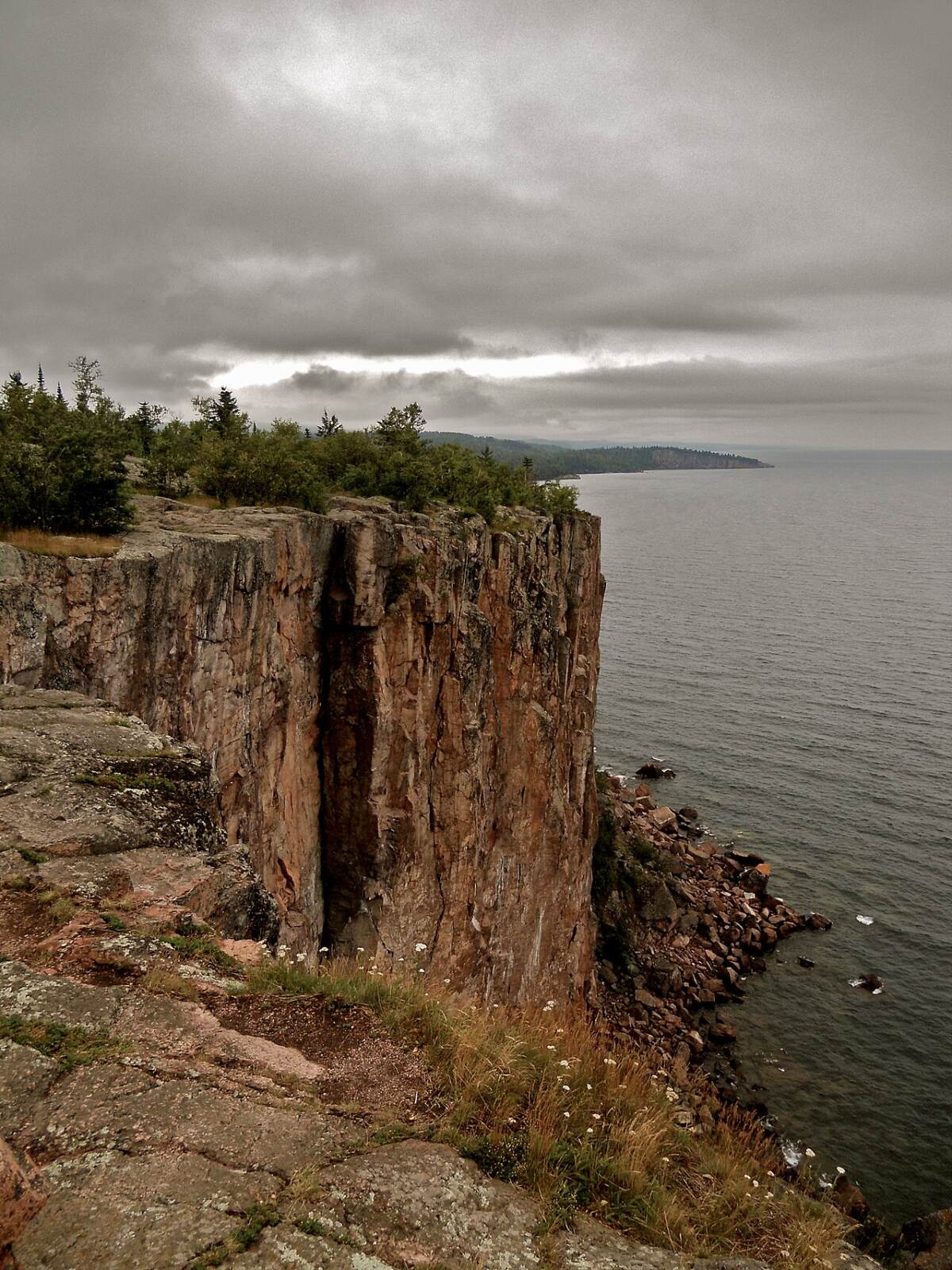
About 1.5 miles southwest of the visitor center, a narrow, steep road off Highway 61 climbs to the top of Palisade Head, sheer rhyolite cliffs rising more than 300 feet above the lake. On a clear day the view stretches for miles along the shore and far out across the lake. There are no railings at the edge, so keep kids and dogs close. The road is narrow with limited parking and usually closes in winter.
Other Trails in Tettegouche State Park
| Trail | Distance | Highlights |
|---|---|---|
| High Falls (from visitor center) | About 3 miles round trip | Two Step Falls, High Falls, new bridge |
| Shovel Point | About 1.2 miles round trip | Cliffs, sea caves, Lake Superior views |
| Tettegouche Camp / Mount Baldy | About 3.5-mile loop | Inland lakes, historic camp, a hilltop overlook |
| Superior Hiking Trail | Varies | Ridge views over the park and the lake |
| Palisade Valley and inland trails | Varies | Quiet forest, overlooks, fall color |
The park has more than 20 miles of hiking trails, plus ski trails in winter.
Best Time to Visit
| Season | What to expect |
|---|---|
| Spring (April–May) | The falls are at their biggest from snowmelt. Muddy trails, lingering ice early on, cold days. |
| Summer (June–August) | Warm, green and busy. Cool breezes off the lake. Bugs in early summer. Book camping early. |
| Fall (mid-September–October) | Gorgeous color, usually peaking in late September to early October. Big weekend crowds. |
| Winter (November–March) | Snowy, quiet and beautiful. Frozen falls, icy stairs. Cross-country skiing and snowshoeing. |
Weather tip: Lake Superior makes its own weather. In summer, it can be 15–20°F cooler by the lake than a few miles inland, with fog rolling in fast. In fall and winter, wind off the lake makes the cliffs feel much colder. Check the National Weather Service forecast for Silver Bay, bring layers, and check the park’s alerts page before you go.
Tettegouche State Park Camping
| Option | What it’s like |
|---|---|
| Baptism River Campground | Drive-in sites, some with electric hookups, near the High Falls trailhead. A heated shower building stays open year-round, which is rare for Minnesota state parks. |
| Lake Superior cart-in sites | Park and wheel your gear a short way to quiet sites near the lakeshore. |
| Walk-in and backpack sites | More private sites in the woods, plus Superior Hiking Trail campsites. |
| Group camp | For larger groups; reopened after the bridge project. |
Camping Reservations
- All campsites and lodging need a reservation, even if you book the same day.
- Book up to 120 days ahead on Minnesota’s state park reservation website or by phone at 866-857-2757.
- Same-day reservations are allowed when sites are open, and they don’t carry the usual reservation fee.
- Summer and fall weekends fill fast, often the day they open up.
Tettegouche Cabins
- Tettegouche Camp: Four historic log cabins and a lodge on Mic Mac Lake, built by the Tettegouche Club in the early 1900s and listed on the National Register of Historic Places. You hike in (about 1.5 miles, over a ridge) or ski in during winter. Rustic, peaceful and very special.
- Illgen Falls Cabin: A modern, drive-up cabin above Illgen Falls on the Baptism River. It sleeps up to six, has two bedrooms and a kitchen, and is open year-round. Bring your own bedding.
Both book up far ahead, especially for fall color weekends.
Permits, Parking and Fees
| Permit | Cost |
|---|---|
| One-day vehicle permit | $7 |
| Year-round vehicle permit (all Minnesota state parks) | $35 |
| Additional year-round permit | $26 |
- Buy a permit online, at the visitor center, or at the self-service kiosk.
- Visitor center lot: The park map notes a permit exemption for the visitor center lot, which also serves as a rest area. To park anywhere else in the park, including the High Falls trailhead and campgrounds, you need a permit.
- Free park days: Minnesota offers a few free entry days a year.
- Camping overnight? A one-day permit bought on arrival covers you until 4 p.m. the next day.
Dogs and Kids
Dogs are welcome on park trails and in campgrounds on a leash of 6 feet or shorter, but not inside buildings or most cabins. Clean up after them, and keep a tight hold near cliffs and stairs.
Kids usually love the High Falls hike: stairs, a bridge and two waterfalls. For younger children, the short route from the High Falls trailhead is easier. Hold hands near the gorge and anywhere on Shovel Point and Palisade Head; the cliffs are steep and some edges have no rails.
What to Bring
- Shoes with good grip for wet roots, rock and stairs
- Ice cleats from November to April
- A warm layer and a rain jacket; it’s always cooler by the lake (see our waterproof hiking jacket guide)
- Water and snacks
- Bug spray in June and July
- A camera or phone with a full charge
Best Photo Spots
- High Falls from below: a vertical shot shows off the full drop. Cloudy days give the softest light.
- The new bridge: look down into the gorge, or shoot the bridge itself framed by fall color.
- Two Step Falls: great for long-exposure “silky water” shots.
- Shovel Point: sea caves and the sea stack in morning light.
- Palisade Head: the classic view of Shovel Point at sunset.
One Perfect Day at Tettegouche
- Morning: Stop at the visitor center, then hike to Two Step Falls and High Falls and cross the new bridge (2–3 hours).
- Lunch: Picnic by the river mouth, or head into Silver Bay.
- Afternoon: Walk out to Shovel Point (about 1 hour).
- Evening: Drive up Palisade Head for sunset (when the road is open).
With two days, add the Tettegouche Camp and Mount Baldy loop, or stay a night in the historic cabins.
Common Mistakes to Avoid
- Believing old posts that say the High Falls bridge is closed. It reopened in November 2025.
- Underestimating the stairs. Three miles feels longer with all those steps.
- Parking inland without a permit.
- Showing up to camp without a reservation.
- Getting too close to cliff edges at Shovel Point and Palisade Head.
- Wearing sneakers on icy stairs in late fall and winter.
Tettegouche High Falls Trail FAQs
How long is the High Falls Trail at Tettegouche?
About 3 miles round trip from the visitor center, or about 1 mile round trip from the inland High Falls trailhead.
How tall is High Falls?
63 feet, the tallest waterfall located entirely within Minnesota.
Is the High Falls bridge open?
Yes. The new bridge opened on November 24, 2025, along with the High Falls trailhead parking lot.
Is the High Falls Trail hard?
It’s moderate: short, but with many wooden stairs, roots and rock.
Do you need a permit to visit Tettegouche?
Yes, to park inside the park: $7 for a day or $35 for a year. The visitor center lot is noted as exempt on the park map.
How long is the Shovel Point Trail?
About 0.6 miles each way (1.2 miles round trip), with roughly 300 steps.
Can you camp at Tettegouche State Park?
Yes: drive-in, cart-in, walk-in and backpack sites, plus cabins. All need a reservation, up to 120 days ahead.
Is Tettegouche open in winter?
Yes, year-round, with snowshoeing, skiing and winter camping. Expect icy stairs.
Are dogs allowed?
Yes, on a 6-foot leash on trails and in campgrounds, but not in buildings.
How do you pronounce Tettegouche?
“TET-uh-gooch.”
Can you see High Falls and Shovel Point in one day?
Yes, easily. Together they take about 3–4 hours of walking.
When is the best time to see the falls?
Spring, during snowmelt, for the most water. Late September to early October for fall color.
Is Tettegouche Worth It?
Absolutely. Waterfalls, a forest river gorge, Lake Superior cliffs, historic cabins and a brand-new bridge, all in one park. If you only have time for one stop on the North Shore, many locals would tell you to make it this one.
Wear good shoes, buy your permit, book camping early, and give yourself at least half a day. And bring a jacket. The lake always has the last word on the weather.