
Picture a ridge of broken granite a mile long, in places only a few feet wide, with the ground falling away more than 1,000 feet on both sides. On your left, a deep glacial bowl with a tiny pond at the bottom. On your right, endless Maine forest and lakes. Ahead, the highest point in Maine. That’s the Knife Edge on Mount Katahdin, and it’s the most famous, most thrilling and most feared trail in New England.
The Knife Edge itself is just 1.1 miles long, linking Pamola Peak and Baxter Peak. But getting there, crossing it and getting back down takes a full, hard day, usually 8–12 hours. It’s an expert route, and Baxter State Park warns that people have died and been seriously hurt on it, especially in bad weather and high winds.
This guide covers it all: the route options and map, a step-by-step walk across the ridge, parking reservations, weather, Katahdin’s height, camping, accidents and safety, and whether it’s right for you.
Cover photo: two hikers on Katahdin’s Knife Edge at sunrise. Photo: Jamie Walter / America’s Byways (public domain)
Important: Katahdin is closed right now. Baxter State Park closed all Katahdin and Traveler Ridge trails for the season as of October 13, 2026, to protect the alpine plants and trails. The winter season runs December 1 to March 31, and climbing above treeline in winter requires a special park application. Summit trails usually reopen in late spring or early summer; in 2026, all park trails were open by June 10. Use this guide to plan your 2027 trip, and check the park’s news page for opening dates.
Knife Edge Trail: The Short Answer
The Knife Edge is a 1.1-mile exposed granite ridge on Mount Katahdin in Baxter State Park, Maine, connecting Pamola Peak (4,919 ft) and Baxter Peak (5,268 ft), the highest point in Maine. Most hikers start at Roaring Brook, climb the Helon Taylor Trail to Pamola, cross the Knife Edge (1–1.5 hours), and descend the Saddle Trail. The whole loop is about 9–10 miles with around 4,000 feet of climbing and takes 8–12 hours. It’s for experienced, fit scramblers only, and only on calm, clear days. Book a Katahdin Trailhead parking pass in advance; dogs aren’t allowed.
Quick Facts
| Detail | Information |
|---|---|
| Location | Baxter State Park, near Millinocket, Maine |
| Knife Edge length | 1.1 miles, Pamola Peak to Baxter Peak |
| Time to cross | About 1–1.5 hours one way (park estimate) |
| Classic loop | About 9–10 miles; about 4,000 ft of climbing |
| Full day | 8–12 hours |
| Summit height | Baxter Peak, 5,268 ft (new 2026 sign) |
| Main trailhead | Roaring Brook Campground |
| Difficulty | Very strenuous; exposed scrambling |
| Parking | Katahdin Trailhead Pass (KTP) reservation |
| Season | Usually late spring/early summer to mid-October |
| Water on the ridge | None |
| Dogs | Not allowed anywhere in Baxter State Park |
Where Is Mount Katahdin?
Katahdin rises out of the North Maine Woods inside Baxter State Park, about 20 miles northwest of the town of Millinocket and roughly 85 miles north of Bangor. Most hikers enter at the Togue Pond Gate south of the mountain. From there, it’s about 8 miles on a gravel road to Roaring Brook, the trailhead for the Knife Edge.
- From Bangor: I-95 north to Medway (Exit 244), then Route 157 west to Millinocket and the park road north to Togue Pond. About 1.5–2 hours.
- From Portland: about 3.5–4 hours.
- From Boston: about 5.5–6 hours.
Baxter State Park was a gift to the people of Maine from former Governor Percival Baxter, who bought the land piece by piece and asked that it stay “forever wild.” That’s why the park feels so different from most parks: gravel roads, no electricity, no running water at most campgrounds, strict limits on visitors and no cell service on most of the mountain.
Not to be confused with Acadia: Katahdin is in central Maine, about 3 hours from Acadia National Park on the coast.
How Tall Is Mount Katahdin?
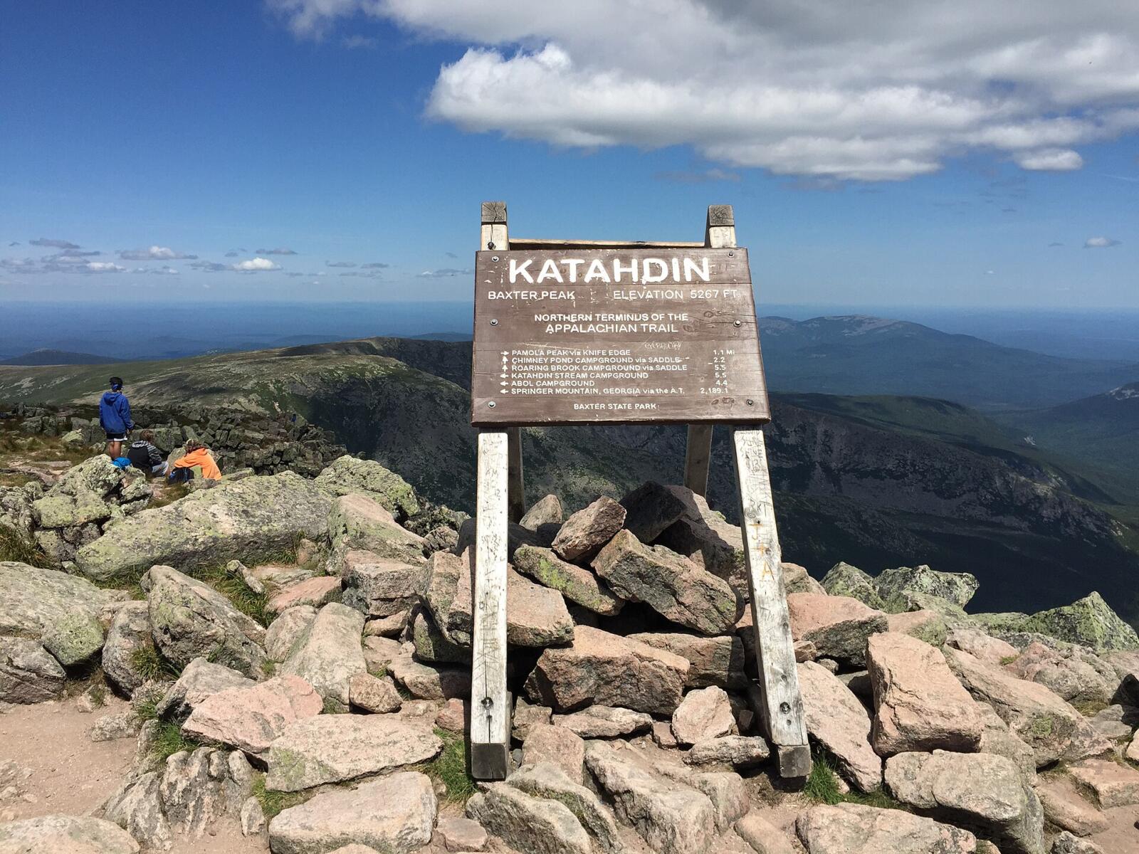
Katahdin’s highest point, Baxter Peak, is 5,268 feet above sea level, the highest in Maine. You’ll still see 5,267 feet on older signs, maps and websites. In 2026, the park installed a new summit sign reading 5,268 feet, matching the USGS figure and a recent University of Maine survey that measured about 5,268.8 feet.
That doesn’t sound huge next to western peaks, but Katahdin rises more than 4,000 feet from its base, and its upper slopes are bare rock exposed to wild weather. That’s why it hikes much bigger than its height.
| Peak | Elevation |
|---|---|
| Baxter Peak (summit) | 5,268 ft |
| South Peak (on the Knife Edge) | About 5,240 ft |
| Pamola Peak | 4,919 ft |
| Hamlin Peak | 4,756 ft |
| Chimney Pond | About 2,900 ft |
| Roaring Brook trailhead | About 1,500 ft |
Baxter Peak is also the northern end of the Appalachian Trail, the finish line for thru-hikers who’ve walked about 2,200 miles from Georgia. If that story inspires you, see our list of the best Appalachian Trail books.
What Is the Knife Edge?
The Knife Edge is an arête, a thin rock ridge left behind when glaciers carved out bowls on both sides. On the north side is the Great Basin with Chimney Pond; on the south, the cliffs drop toward Katahdin’s southern slopes. The trail follows the crest of the ridge over jagged blocks of granite, with almost no way off it except at either end.
- Length: 1.1 miles between Pamola and Baxter Peak.
- Climbing: Only about 365 feet net, but with lots of up and down.
- Width: In the narrowest spots, a few feet, with steep drops on both sides.
- The Chimney: A deep notch right next to Pamola that you climb down into and back out of, the hardest move on the ridge.
- Time: The park estimates 1–1.5 hours to cross. Many people take longer.
Knife Edge Trail Map: Route Options
You can’t drive to the Knife Edge. You have to climb Katahdin first. Here are the main ways people include it:
| Route | Start | Approx. distance | Notes |
|---|---|---|---|
| Helon Taylor → Knife Edge → Saddle → Chimney Pond (classic) | Roaring Brook | About 9–10 miles loop | The most popular way. You cross the Knife Edge from Pamola toward Baxter Peak. |
| Chimney Pond → Cathedral → Knife Edge → Helon Taylor | Roaring Brook | About 9–10 miles loop | Cathedral is a steep boulder climb. Crossing from Baxter to Pamola means down-climbing the Chimney. |
| Hunt Trail (Appalachian Trail) to Baxter Peak | Katahdin Stream | 5.2 miles one way; 10.4 round trip; about 4,188 ft gain | No Knife Edge. Still very hard, with big boulder scrambles. |
| Abol Trail to Baxter Peak | Abol | About 4.3 miles one way | The shortest route; steep and loose. No Knife Edge. |
| Saddle Trail via Chimney Pond | Roaring Brook | About 4.4 miles one way | Often called the “easiest” way up from the east. No Knife Edge. |
Which direction? Most people go Pamola to Baxter Peak. That way you climb up out of the Chimney instead of down into it, and you end at the summit with an easier way down on the Saddle Trail. Going the other way means down-climbing the hardest part when you’re tired.
Pick up a Baxter State Park trail map before your trip. Phone apps are helpful, but there’s little or no signal on the mountain, so download maps ahead of time.
Hiking the Knife Edge: Step by Step (Classic Loop)
1. Roaring Brook and the Helon Taylor Trail (3.2 Miles)
Sign in at the ranger station register and read the day’s posted weather. The Helon Taylor Trail starts in the woods and climbs steadily. It’s about 3.2 miles with roughly 3,400 feet of climbing to Pamola Peak. Once you break above the trees on Keep Ridge, it becomes a steep, exposed staircase of boulders. The views open up and so does the wind. The park rates this trail very strenuous and warns against it in bad weather.
2. Pamola Peak: Your Decision Point
At Pamola Peak (4,919 ft), the whole Knife Edge stretches out ahead of you to Baxter Peak. This is where you decide. If it’s windy, wet, foggy, icy, getting late or someone in your group is struggling, turn around and go back down Helon Taylor. Once you’re on the ridge, there’s no easy way off.
The peak is named for Pamola, a storm spirit from Penobscot tradition said to live on the mountain and guard it from people. On a bad-weather day, you’ll understand why.
3. The Chimney
Right after Pamola, the ridge drops into a steep, narrow notch: the Chimney. You’ll climb down rock ledges using your hands, then scramble back up the other side. It’s the most technical part of the hike. Face the rock where it’s steep, test every handhold, and take your time. Don’t feel pressured by people waiting behind you.
4. Across the Ridge
From the Chimney, the trail follows the crest over a long line of jagged granite blocks toward South Peak, then on to Baxter Peak. Some stretches are narrow with big drops on both sides; others are broader but rough. Blue blazes mark the way. Keep three points of contact where it’s steep, keep your eyes on your feet, and stop to look around only when you’re standing on solid ground.

5. Baxter Peak
The Knife Edge ends at the summit sign on Baxter Peak, the top of Maine. On a clear day you look over hundreds of lakes and ponds, endless forest, the Tableland to the west and the Great Basin below. You’ll probably meet Appalachian Trail thru-hikers celebrating the end of their journey here. Enjoy it, but remember you’re only about halfway through your day.
6. Down the Saddle Trail and Out
From the summit, walk across the open plateau to the Saddle, then down the Saddle Trail into the Great Basin. The top of the Saddle slide is steep with loose gravel and rock, so watch your footing and don’t kick rocks onto people below. At Chimney Pond, rest by the water beneath the cliffs you just walked along. Then it’s about 3.3 miles on the Chimney Pond Trail back to Roaring Brook. It’s not hard, but it’s long on tired legs.
How Hard Is the Knife Edge?
Baxter State Park rates it very strenuous, and it’s one of the hardest day hikes in the eastern U.S. It isn’t technical climbing; you don’t need ropes on a dry day. But you do need:
- Fitness for 8–12 hours and about 4,000 feet of steep climbing
- Scrambling experience on steep, exposed rock
- A good head for heights
- Good judgment to turn back when the weather or your body says no
Can beginners do it? No. If you’ve never done a long, exposed scramble, build up first on hikes like the Beehive Trail in Acadia and the Franconia Ridge Loop in New Hampshire. Or climb Katahdin by the Saddle Trail or Hunt Trail and look at the Knife Edge from the summit.
Afraid of heights? Be honest with yourself. Freezing up halfway across is dangerous for you and for others. There’s no shame in skipping it.
Mount Katahdin Weather
Weather decides everything on the Knife Edge. Katahdin sits alone above the Maine woods and catches storms, high winds and clouds. It can be sunny at Roaring Brook while the summit is in fog with 50 mph gusts.
- Wind: The biggest danger on the ridge. Strong gusts can knock you off balance on narrow sections. The park says not to cross in high winds.
- Thunderstorms: Common on summer afternoons. There’s nowhere to hide on the ridge. Be off it by early afternoon.
- Fog: Hides blazes and the drop-offs.
- Wet or icy rock: Granite gets very slick. Snow and ice can show up in June and from September on.
- Cold: Summit temperatures are often 20°F colder than the valley, before wind chill.
Check: the National Weather Service forecast for the Katahdin summit area (not just Millinocket), plus the daily weather posting at park trailheads. Rangers may limit or close above-treeline hiking on dangerous days. Follow their call.
Best Time to Hike the Knife Edge
| Month | What to expect |
|---|---|
| Late May–June | Summit trails open once snow clears (all trails were open by June 10 in 2026). Lingering snow, mud, and lots of black flies. |
| July | Long days, the most stable weather, but afternoon thunderstorms. Busy; reserve parking early. |
| August | Often the best month. Fewer bugs, warm days. Still watch for storms. |
| September | Cool, clear and colorful down low. Shorter days and the first frosts up top. |
| Early October | Cold, icy mornings and short days. Summit trails usually close around mid-October (October 13 in 2026). |
| November–May | Closed to normal hiking. Winter climbing above treeline needs special park approval. |
Knife Edge Deaths, Accidents and Safety
Yes, people have died on the Knife Edge. Baxter State Park says plainly that fatalities and serious injuries have happened there, especially in bad weather and high winds. Rangers also respond to many rescues on Katahdin each season, often for tired, cold or injured hikers on the long way down. We won’t give a death count, because there isn’t a reliable, official running total.
How to stay safe:
- Start early. Be on the trail at first light.
- Set a turnaround time and keep it, no matter how close the summit looks.
- Only cross on calm, dry, clear days.
- Make the go/no-go call at Pamola Peak, not halfway across.
- Hike with a partner and stay together.
- Carry a headlamp (the park requires one) and extra warm layers.
- Sign in and out at the trailhead register.
Parking Reservations and Fees
Baxter limits how many cars can park at each Katahdin trailhead. To be sure of a spot, reserve a Katahdin Trailhead Pass (KTP) on the park’s reservation site.
- Book the right trailhead: Roaring Brook for the Knife Edge (Helon Taylor, Chimney Pond, Saddle, Cathedral). Katahdin Stream is for the Hunt Trail, and Abol for the Abol Trail. The trailheads are far apart by road.
- Cost: The park listed the KTP at about $10 per vehicle for 2026.
- When to book: In 2026, passes went on sale April 1 at 6 a.m. Eastern. Summer weekends sell out quickly.
- Arrive early: Reserved spots are only held until a set time in the morning; if you’re late, your spot can be given away.
- Entrance fee: Vehicles with Maine plates enter free; non-Maine vehicles pay a daily entrance fee at the gate.
- No reservation? Any leftover spaces go first-come, first-served at the gate, but don’t count on it in summer.
Rules change from year to year, so check the park’s reservation page before you book.
Camping Near Mount Katahdin
| Campground | Best for | Notes |
|---|---|---|
| Roaring Brook | Knife Edge via Helon Taylor or Chimney Pond | Right at the trailhead; lean-tos and tent sites |
| Chimney Pond | Saddle, Cathedral and an early Knife Edge start | Hike-in only (about 3.3 miles); bunkhouse and lean-tos below the cliffs |
| Katahdin Stream | Hunt Trail / Appalachian Trail | West side of the mountain |
| Abol | Abol Trail | Southwest side; near Abol Stream |
| Millinocket and nearby lakes | Hotels, cabins and private campgrounds | 30–45 minutes to the gate |
Baxter campsites use a rolling reservation window and book up fast, especially Chimney Pond. Camping at the trailhead lets you start at dawn without a long drive and the gate line. There’s no food for sale in the park, so bring everything you need.
What to Pack
- Sturdy boots or shoes with sticky soles for granite
- At least 3 liters of water; there’s none above treeline (treat any water from Chimney Pond streams)
- A big lunch and lots of snacks
- Rain jacket and wind layer (see our waterproof hiking jacket guide)
- Warm layer, hat and gloves, even in August
- Headlamp (required by park rules for summit hikers)
- Map and offline GPS
- First-aid kit and an emergency blanket
- Bug spray or a head net in June and July
- Trekking poles for the approach and descent, strapped to your pack on the ridge (see budget trekking poles)
- A small pack that won’t throw you off balance
Dogs, Kids and Park Rules
- No pets are allowed anywhere in Baxter State Park.
- Kids: The park discourages young children on Katahdin’s summit trails, and the Knife Edge isn’t a place for kids.
- Carry in, carry out. There are no trash cans in the park.
- Stay on the trail above treeline. Katahdin’s alpine plants are rare and fragile.
- No drones and no generators.
A Sample Knife Edge Day
- Before dawn: Drive to Togue Pond Gate (or wake up at Roaring Brook). Check the posted weather.
- 6:00 a.m.: Sign in and start up the Helon Taylor Trail.
- 9:30 a.m.: Pamola Peak. Go or no-go.
- 9:45–11:15 a.m.: Cross the Knife Edge.
- 11:15 a.m.: Baxter Peak. Lunch and photos.
- Noon–2:00 p.m.: Down the Saddle Trail to Chimney Pond.
- 2:00–4:00 p.m.: Chimney Pond Trail back to Roaring Brook. Sign out.
Common Mistakes to Avoid
- Thinking “1.1 miles” means short. The full day is 9–10 miles.
- Booking the wrong trailhead. For the Knife Edge, it’s Roaring Brook.
- Crossing in wind or fog because you drove a long way.
- Starting late. Afternoon storms and darkness catch people out.
- Going Baxter-to-Pamola without experience, which means down-climbing the Chimney.
- Showing up in October without checking whether the trails have closed.
Mount Katahdin Knife Edge FAQs
How long is the Knife Edge Trail?
1.1 miles between Pamola Peak and Baxter Peak. A full hike that includes it is usually about 9–10 miles.
How long does it take to cross the Knife Edge?
The park estimates 1–1.5 hours one way. The whole day usually takes 8–12 hours.
How tall is Mount Katahdin?
Baxter Peak is 5,268 feet, as shown on the park’s new 2026 summit sign. Older sources say 5,267.
Is Mount Katahdin open now?
No. All Katahdin trails closed for the season on October 13, 2026. They usually reopen in late spring or early summer.
Has anyone died on the Knife Edge?
Yes. Baxter State Park says people have died or been seriously hurt crossing it, most often in bad weather or high winds.
Which trailhead is best for the Knife Edge?
Roaring Brook, for the Helon Taylor Trail up and the Saddle or Chimney Pond trails down.
Do I need a reservation to hike Katahdin?
A Katahdin Trailhead Pass parking reservation is strongly recommended; without one you may not get a spot.
Do you need climbing gear for the Knife Edge?
Not in dry summer conditions. It’s a hand-and-foot scramble, not a roped climb.
Can beginners hike the Knife Edge?
No. It’s for experienced hikers who are comfortable scrambling on exposed rock.
What’s the easiest way up Mount Katahdin?
There’s no easy way, but the Saddle Trail from Chimney Pond is usually considered the least difficult, followed by the Hunt (Appalachian) Trail.
Can you camp near Mount Katahdin?
Yes, at Baxter State Park campgrounds like Roaring Brook, Chimney Pond, Katahdin Stream and Abol, by reservation.
Are dogs allowed on Mount Katahdin?
No. Pets aren’t allowed anywhere in Baxter State Park.
Is the Knife Edge Worth It?
For experienced hikers on a perfect day, it’s one of the most unforgettable mile-long walks in America: a granite tightrope in the sky, glacial bowls on both sides, and the top of Maine at the end. Few hikes in the East come close.
But the mountain makes the rules. Book your parking early, start at dawn, make your call at Pamola Peak, and turn around without regret if the wind is up or the clouds roll in. Katahdin has been there for 400 million years. It will still be there next summer.