
From the rim at Sunset Point, the Navajo Loop looks like nothing. It’s only 1.3 miles, after all. Then you start down the switchbacks, the rock walls rise up around you, and twenty minutes later you’re standing at the bottom of a narrow slot looking up at fir trees that have been reaching for the light for centuries.
And then you have to climb back out.
That’s the thing people underestimate about the Navajo Loop Trail. In Bryce Canyon, hikes start at the top, so going down is the easy part. The 515-foot climb back to the rim, at around 8,000 feet, is where you’ll feel it. This guide covers everything you need to know before you go: the route step by step, Wall Street vs Two Bridges, which direction to hike, winter closures, parking and the shuttle, and whether you should combine it with Queen’s Garden.
Navajo Loop Trail: Quick Answer
The Navajo Loop Trail is a 1.3-mile moderate loop in Bryce Canyon National Park that starts and ends at Sunset Point. It drops 515 feet into Bryce Amphitheater and takes 1 to 2 hours. The loop has two sides: Wall Street, a narrow slot with famous switchbacks that closes in winter, and Two Bridges, which is open all year and passes Thor’s Hammer. In summer, the park recommends hiking it counter-clockwise. For most first-time visitors, combining it with Queen’s Garden makes an even better 2.9-mile hike.
Navajo Loop Trail at a Glance
| Trailhead | Sunset Point |
| Distance | 1.3 miles (2.1 km) round trip |
| Elevation change | 515 feet (157 m) |
| Time | 1 to 2 hours |
| Difficulty | Moderate |
| Steepness | About 14% on average, up to 30% in places |
| Surface | Packed dirt and sand; narrows to about 2 feet in spots |
| Two sides | Wall Street (west) and Two Bridges (east) |
| Direction | Counter-clockwise when the full loop is open |
| Winter | Wall Street closed; Two Bridges usually open |
| Highlights | Wall Street, Douglas firs, Thor’s Hammer, Two Bridges |
| Shuttle stop | Yes, Sunset Point |
| Restrooms and water | At Sunset Point only, none below the rim |
| Dogs | Not allowed |
| Permit | None needed beyond park entry |
In This Guide
- The route, step by step
- Wall Street vs Two Bridges and which direction to hike
- How hard is it?
- Trailhead, parking and the shuttle
- Combining with Queen’s Garden and Peekaboo
- Navajo Loop in every season
- Kids, beginners, dogs and accessibility
- What to bring and photo tips
- FAQs
Is the Navajo Loop Worth Hiking?
Yes. It’s one of the best short hikes in any national park. The magic isn’t the distance. It’s how much you get in such a small space: a big view from the rim, a stack of steep switchbacks, a narrow slot lined with towering walls, trees growing up from the shadows, Thor’s Hammer up close and a natural double arch. Looking at hoodoos from above is impressive. Standing at their feet is when you understand how big they really are.
The Navajo Loop Route, Step by Step
Here’s what to expect when the full loop is open, hiking counter-clockwise as the park recommends: down the Wall Street side and back up the Two Bridges side.
1. Start at Sunset Point
Before you head down, take a few minutes at the overlook. You’re looking straight into the Silent City, a crowd of hoodoos packed below the rim, and you can trace much of the trail you’re about to walk. Fill your water bottle at Sunset Point, since there’s none below the rim, and use the restroom here too.
2. Take the Wall Street (Right-Hand) Side Down
Just below the rim, the trail splits. Take the right-hand (west) branch toward Wall Street. Near the top, look for a short side path that leads through a small tunnel to a window in the rock, with a view into the next canyon. It takes a minute and most people walk right past it.
Then the famous part begins. The trail drops down a tight stack of switchbacks carved into the cliff, one directly above the next. Go slowly. The surface is sandy and loose in places, and this is where most slips happen.
3. Walk Through Wall Street
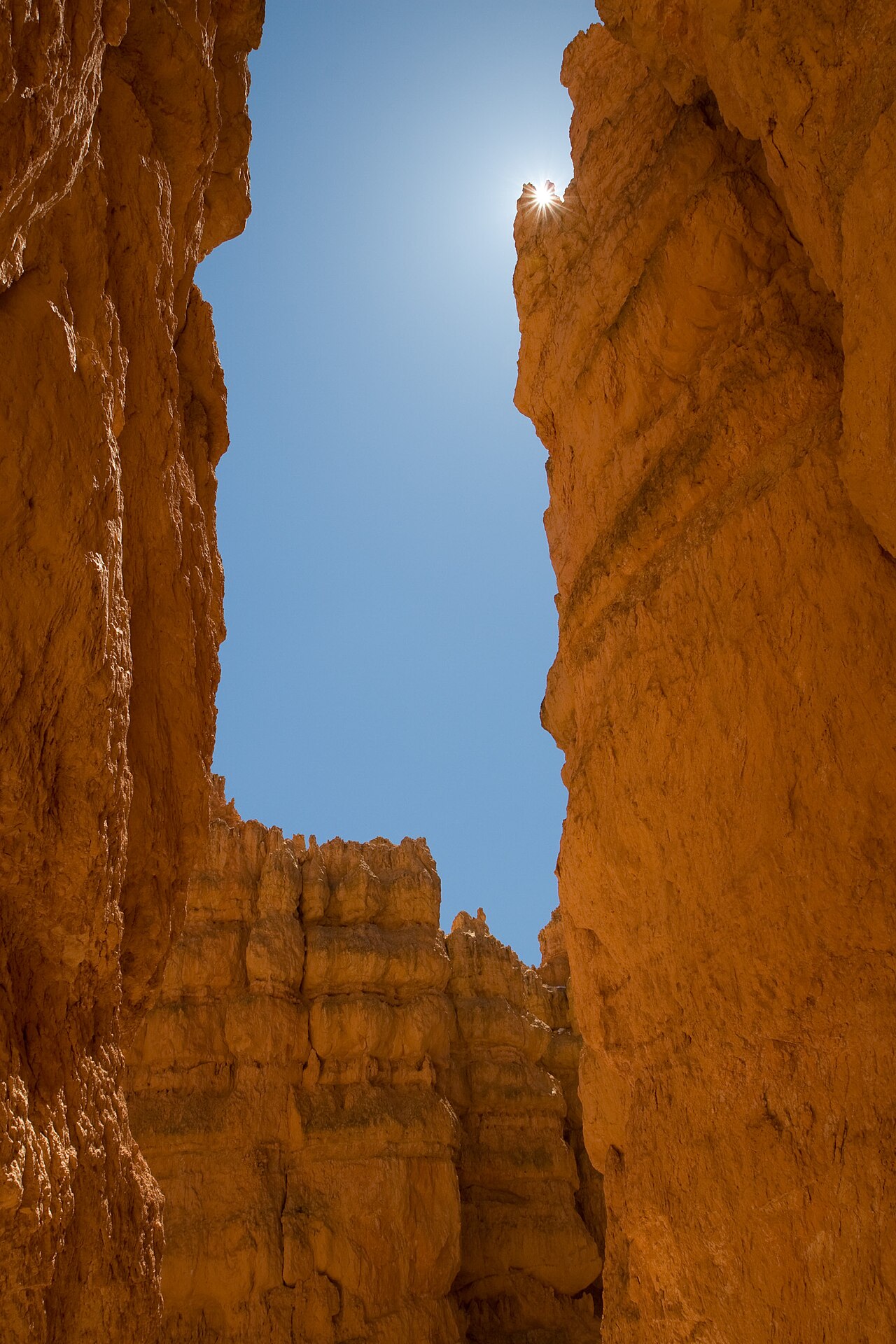
At the bottom of the switchbacks, the trail squeezes into a narrow slot between walls of orange limestone more than a hundred feet tall. It’s cool and shady even on hot days, and it really does feel like walking between skyscrapers, which is how it got its name.
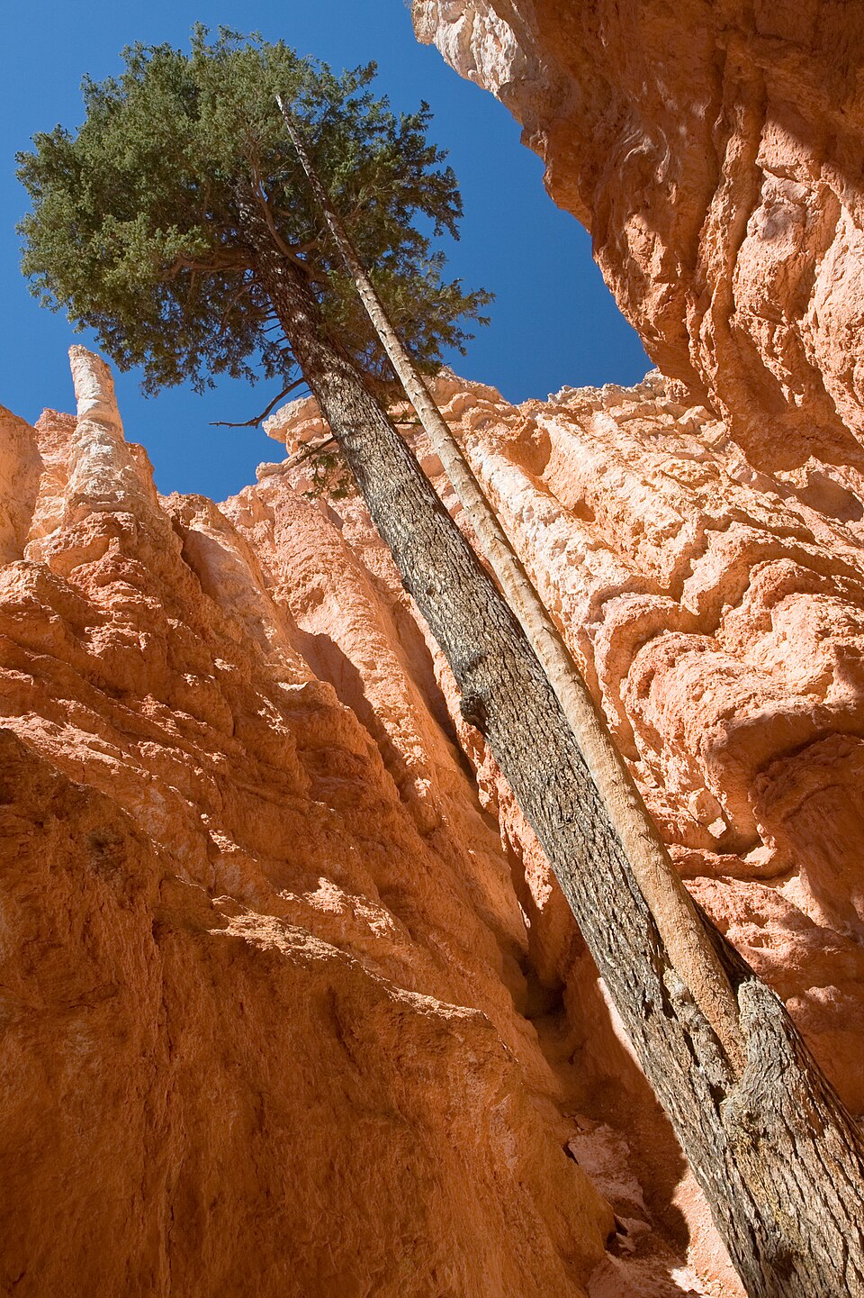
Look for the tall Douglas fir trees growing straight up out of the slot, stretching toward the sliver of sky far above. They’re often said to be several hundred years old. It’s one of the most surprising sights in the park.
4. Reach the Junction on the Canyon Floor
After Wall Street, the trail follows a dry wash to a junction at the lowest point of the hike. This is where the Navajo Loop meets the trail to Queen’s Garden and the connector to the Peekaboo Loop. Signs point the way. To finish the Navajo Loop, turn back uphill toward Two Bridges.
5. Climb the Two Bridges Side
The climb out starts gently, then steepens into another set of switchbacks. Along the way you’ll pass Two Bridges, a pair of small natural arches stacked in a fin of rock beside the trail.
6. Pass Thor’s Hammer and Return to the Rim
Near the top, Thor’s Hammer appears right beside the trail: a tall, skinny hoodoo with a big block of harder rock balanced on top. It’s the most photographed rock in the park, and from here you see it at eye level instead of from above. A last few switchbacks bring you back to Sunset Point. Take your time on this final climb, and stop to catch your breath. Everyone does.
Wall Street vs Two Bridges: What’s the Difference?
The two halves of the Navajo Loop both drop into the amphitheater and meet at the bottom, but they feel very different.
| Wall Street | Two Bridges | |
|---|---|---|
| Side of loop | West (right as you start) | East (left as you start) |
| Feel | Narrow, shady slot with tall walls | More open, with hoodoo views |
| Highlights | Famous switchbacks, Douglas firs | Thor’s Hammer, two small arches |
| Season | Usually closed in winter | Usually open all year |
| Best direction | Down (in summer) | Up (in summer) |
| Best for | The iconic Bryce photo | Reliable access, Thor’s Hammer |
When both are open, do the full loop and see both. Don’t think of Two Bridges as the backup. It has the best close-up view of Thor’s Hammer in the park, and it’s a beautiful trail in its own right.
Is Wall Street Open?
Not always. The Wall Street side closes in winter because of serious rockfall danger. When rain or melting snow gets into cracks in the cliffs and freezes overnight, the ice pries rock loose, and the narrow slot is the worst place to be when that happens. The exact closing and opening dates depend on the weather each year, not the calendar, so it can stay closed into spring or close early in fall. Wall Street can also close at other times after rockfall.
Before you go, check the sign at the trailhead, ask at the visitor center or look at the park’s current conditions page. If it’s closed, never walk around the barriers.
Which Direction Should You Hike the Navajo Loop?
When the full loop is open, the park recommends hiking counter-clockwise: down the Wall Street side and back up the Two Bridges side. This way you descend the narrow switchbacks with the slot opening up in front of you, and you climb out on the side with Thor’s Hammer waiting near the top. Always follow any signs at the trailhead, since directions can change.
When Wall Street is closed, the Navajo Loop isn’t a loop anymore. You can hike Two Bridges as an out-and-back trail, going down and returning the same way, or use it as part of a longer hike with Queen’s Garden.
How Hard Is the Navajo Loop?
The park rates it moderate, and that’s fair, but the short distance makes it sound easier than it is. You lose and regain 515 feet in just over a mile, the trail averages a 14% grade and hits 30% in places, and the climb out comes at the end, when you’re already tired.
Then there’s the altitude. Bryce sits around 8,000 feet, where each breath holds roughly a quarter less oxygen than at sea level. Someone who finds a mile-long hill easy at home may be gasping halfway up the switchbacks here. That’s normal, and it has little to do with fitness.
To make it easier: go slowly on the climb, rest whenever you need to, drink water, and avoid doing the hike within a few hours of arriving from sea level if you can. Headache, nausea or dizziness are signs to stop, rest and turn back.
Trailhead, Parking and the Shuttle
The Navajo Loop starts and ends at Sunset Point, one of the four main viewpoints in Bryce Amphitheater, about 2 miles from the park entrance. The trailhead is right beside the overlook.
Parking: Sunset Point has a parking lot, restrooms and water, but it’s one of the busiest spots in the park and fills by mid-morning from spring to fall. Oversized vehicles aren’t allowed to park here while the shuttle is running.
Shuttle: The free park shuttle stops at Sunset Point. In 2026 it runs from April 3 to October 18, with buses about every 15 minutes. Park at the shuttle station in Bryce Canyon City or the extra lot across from the visitor center, ride in, and skip the parking hunt completely. It’s included with your park entry.
Fees: There’s no separate trail fee or permit. You just need your park entry: $35 per private vehicle for seven days in 2026, plus a $100 per-person nonresident fee for non-U.S. residents aged 16 and older.
Should You Combine the Navajo Loop With Other Trails?
Because the Navajo Loop meets other trails on the canyon floor, it’s easy to stretch it into a longer hike. Here are the main options:
| Hike | Distance | Climb | Time | Difficulty |
|---|---|---|---|---|
| Navajo Loop only | 1.3 mi | 515 ft | 1–2 hrs | Moderate |
| Queen’s Garden + Navajo | 2.9 mi | 625 ft | 2–3 hrs | Moderate |
| Navajo + Peekaboo | 4.9 mi | 1,475 ft | 3–4 hrs | Strenuous |
| Figure-8 (Queen’s, Peekaboo, Navajo) | 6.4 mi | 1,575 ft | 4–5 hrs | Strenuous |
Queen’s Garden and Navajo Loop: The Best Choice for Most People
If you have about three hours and feel up to it, combine the Navajo Loop with Queen’s Garden. This 2.9-mile loop is the hike the park recommends most to first-time visitors, and it shows you both sides of Bryce: the open hoodoo gardens of Queen’s Garden and the narrow walls and switchbacks of Navajo.
Start at Sunrise Point, walk down the Queen’s Garden Trail, cross the canyon floor to the Navajo junction, climb up the Navajo Loop to Sunset Point, then take the flat, paved half-mile Rim Trail back to Sunrise Point. It sounds backward to climb the steeper trail, but it’s deliberate: going down the gentler side and up the steep side is easier on your knees, and fewer people slip going uphill than downhill. In winter, climb out on the Two Bridges side.
Navajo Loop vs Queen’s Garden
| Navajo Loop | Queen’s Garden | |
|---|---|---|
| Distance | 1.3 mi loop | 1.8 mi round trip |
| Trailhead | Sunset Point | Sunrise Point |
| Steepness | Steeper | Gentlest trail into the amphitheater |
| Scenery | Narrow slot, switchbacks, Thor’s Hammer | Open hoodoo views, Queen Victoria hoodoo |
| Best for | Drama in a short distance | An easier first hike below the rim |
Our verdict: if you can, don’t choose. Do them together.
Navajo Loop vs Peekaboo Loop
Peekaboo is a much bigger hike: 5.5 miles with about 1,560 feet of climbing over 3 to 4 hours. Choose the Navajo Loop if you’re short on time or new to hiking at altitude. Choose Peekaboo, or the Navajo and Peekaboo combination, if you’re a strong hiker with a free morning. For all the options side by side, see our guide to the best hikes in Bryce Canyon National Park.
Hiking the Navajo Loop in Every Season
The best months for the Navajo Loop are usually May, June, September and early October, when temperatures are comfortable, Wall Street is usually open and the trail is free of snow and ice. For month-by-month crowds and conditions, see our guide to the best time to visit Bryce Canyon National Park.
Spring
Spring is unpredictable. Snow and ice can linger on shady switchbacks into April, and Wall Street may still be closed. By May, conditions are usually much easier. Check before you go, and bring traction for your boots early in the season.
Summer
Summer gives you the full loop, long days and the shuttle, but also the biggest crowds and almost daily afternoon thunderstorms in July and August. Lightning is the real danger here, since the rim is exposed. Hike in the morning, watch the clouds, and if you hear thunder, head for a building or a hard-topped car. Don’t wait for the rain to start.
Fall
September is excellent, with comfortable days, cool mornings and fewer storms. October can be lovely too, but freezing nights return, and Wall Street may close for the season once the freeze-thaw cycle starts. For temperatures and snow by month, see Bryce Canyon weather by month.
Winter
In winter, Wall Street closes, but Two Bridges usually stays open as an out-and-back hike or as part of the Queen’s Garden loop. Snow on the hoodoos is spectacular, but the switchbacks get packed into slick ice. Microspikes or similar traction are essential, and the park strongly recommends them. If the trail looks beyond your comfort level, enjoy the view from Sunset Point and the rim instead. There’s no shame in it.
Best Time of Day
Early morning is best. You’ll find cooler air, fewer people on the narrow switchbacks, easier parking, softer light for photos and plenty of time before summer storms. A great plan is to watch sunrise from the rim, then start down the trail as the light reaches the hoodoos. In cooler months, late afternoon also works well. Just leave enough daylight for the climb out.
Is the Navajo Loop Right for You?
Can Beginners Hike It?
Yes, most reasonably fit beginners can, as long as they know it’s not a flat stroll. Take your time on the climb, rest often, carry water and don’t let faster hikers set your pace.
Can Kids Hike It?
Many active kids love it, especially the slot and Thor’s Hammer. It works best for children who already enjoy hiking, can climb steadily without being carried, and will stay close on narrow switchbacks with drop-offs. For younger kids, the paved rim walk between Sunset and Sunrise Points is a better fit.
Are Dogs Allowed?
No. Pets aren’t allowed on the Navajo Loop or any unpaved trail in Bryce, though service animals are permitted. Leashed dogs can join you on the paved rim walk and at the viewpoints.
Is It Wheelchair Accessible?
No. With steep grades, loose sand and narrow sections, it isn’t an accessible trail. The best accessible alternative is the paved Rim Trail between Sunset and Sunrise Points, about half a mile each way and nearly flat, with great views straight down into the area the Navajo Loop passes through. Our guide to Bryce Canyon viewpoints covers more ways to see the park without a steep hike.
What to Bring on the Navajo Loop
It’s a short trail, so pack smart rather than heavy:
- Shoes with good grip. The park says poor footwear is the leading cause of injuries and rescues in Bryce. Skip sandals and smooth-soled sneakers.
- Water. About 1 liter per person is plenty for this hike. Fill up at Sunset Point.
- Sun protection. Hat, sunscreen and sunglasses. The sun is strong at 8,000 feet.
- A light layer, or a warm jacket in spring and fall. The slot is shady and cool.
- Microspikes or other traction from late fall to spring.
- Trekking poles if your knees don’t love steep downhills.
Navajo Loop Photography Tips
- Shoot the switchbacks from above. The classic Wall Street photo is taken from the upper switchbacks looking down. Include a hiker for scale.
- Look up in the slot. The fir trees against the strip of sky make a great vertical shot.
- Isolate Thor’s Hammer. A zoom lens or phone telephoto from the Two Bridges side cuts out the clutter.
- Go early. Low morning light gives the hoodoos depth and glow, while harsh midday sun flattens them.
- Be patient. On a busy day, waiting a minute for a gap in the crowds works better than trying to crop people out later.
Fitting the Navajo Loop Into Your Trip
If you have just a few hours, the Navajo Loop on its own is a great choice, and it leaves time for the viewpoints. With a full day, combine it with Queen’s Garden in the morning and drive the Southern Scenic Drive in the afternoon. With two days, add a longer hike like the Peekaboo Loop or Fairyland so each hike shows you something different. Our Bryce Canyon itinerary lays out how to fit it all together hour by hour.
Common Navajo Loop Mistakes
- Judging it by the distance. 1.3 miles with 515 feet of climbing at 8,000 feet is a real workout.
- Rushing down the switchbacks. Loose sand on steep turns causes most slips.
- Expecting Wall Street to be open in winter or early spring. Check first.
- Wearing the wrong shoes. Grip matters more than anything else here.
- Starting during a summer afternoon storm. Hike in the morning in July and August.
- Missing the window spur near the top of the Wall Street side.
- Doing the Navajo Loop alone when you have time for Queen’s Garden. The combination is the better first hike.
Related Guides
Planning more of this trip? These guides pick up where this one leaves off:
Navajo Loop Trail: FAQs
How long is the Navajo Loop Trail?
About 1.3 miles (2.1 km) round trip, starting and ending at Sunset Point.
How long does the Navajo Loop take?
Most people take 1 to 2 hours. Allow longer for photos, crowds, altitude or icy winter conditions.
Is the Navajo Loop hard?
It’s rated moderate. The distance is short, but you drop and regain 515 feet on grades up to 30%, at around 8,000 feet of elevation.
Which way should you hike the Navajo Loop?
Counter-clockwise when the full loop is open: down the Wall Street side, up the Two Bridges side. In winter, hike Two Bridges as an out-and-back.
Is Wall Street part of the Navajo Loop?
Yes. Wall Street is the west half of the loop. The east half is called Two Bridges.
When is Wall Street closed?
Usually through the winter, when freezing temperatures cause rockfall. Exact dates depend on the weather, and it can also close after rockfall at other times.
Can you see Thor’s Hammer without hiking?
Yes. It’s visible from the rim at Sunset Point. Walking a short way down the Two Bridges side gives you a much closer view.
Is the Navajo Loop or Queen’s Garden better?
Navajo is steeper and more dramatic. Queen’s Garden is gentler with more open views. The best option is to combine them into the 2.9-mile Queen’s Garden and Navajo Loop.
Are there restrooms on the Navajo Loop?
No, only at the trailhead. Sunset Point has year-round accessible restrooms and water-fill stations.
Are dogs allowed on the Navajo Loop?
No. Pets aren’t allowed on the trail. Service animals are permitted.
Do you need a permit or reservation for the Navajo Loop?
No. You only need your regular park entry.
Don’t Judge This Trail by Its Mileage
Few hikes anywhere change your view of a place as fast as the Navajo Loop. At Sunset Point, you’re looking down at Bryce. Twenty minutes later, you’re inside it, with rock walls rising around you and hoodoos that looked tiny from the rim towering overhead. Then comes the climb that turns a sightseeing walk into a real hike.
Got an hour or two? The Navajo Loop is the perfect choice. Got closer to three? Add Queen’s Garden. Either way, go early, wear good shoes, take the climb slowly and enjoy one of the best 1.3 miles in the national park system. For more ideas for your visit, see our guide to the best things to do in Bryce Canyon National Park.