
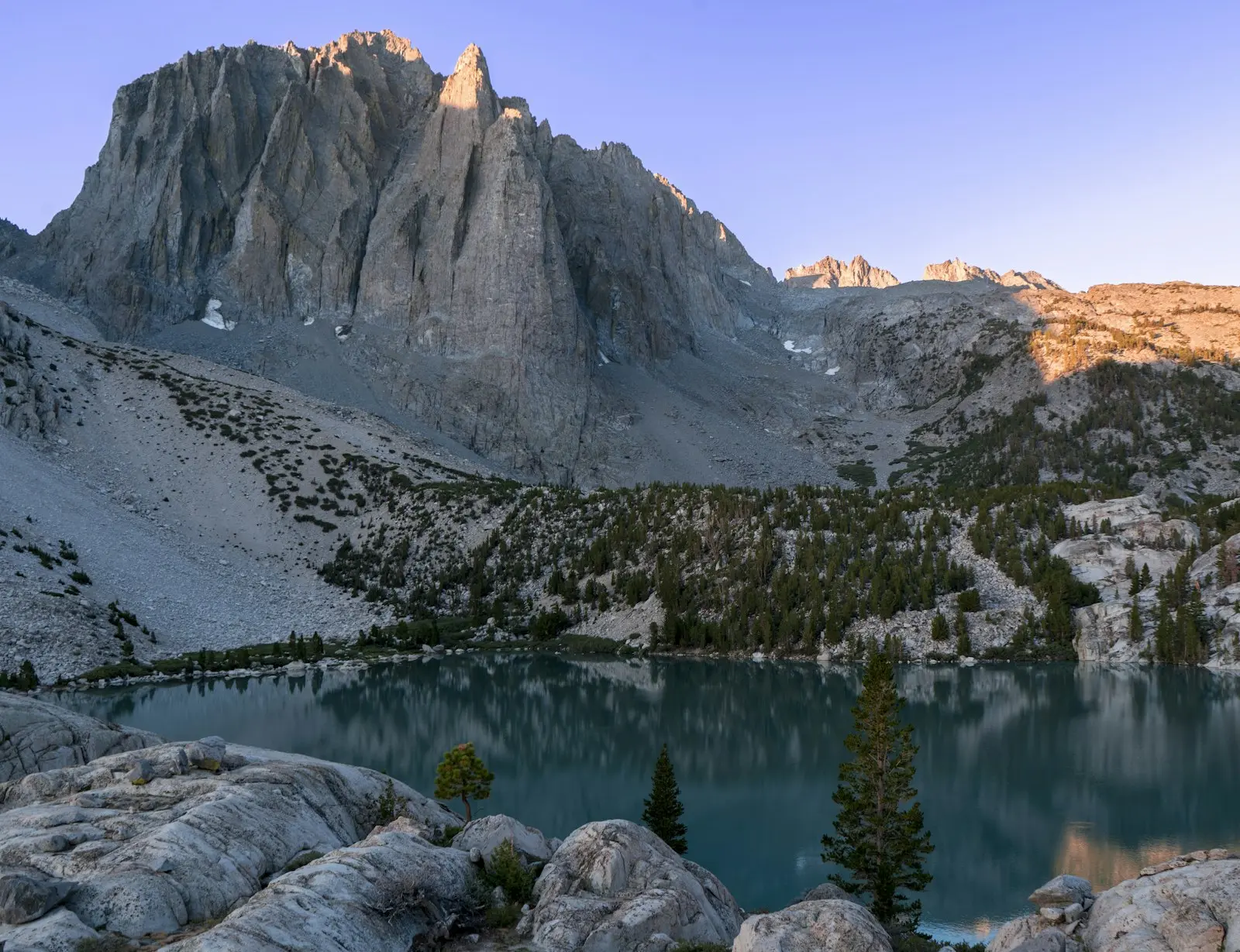
The first time you see Second Lake, it doesn’t look real. The water is a milky turquoise, the kind of color you’d expect in the Canadian Rockies, not two hours from Death Valley. Right behind it, the jagged granite spires of Temple Crag shoot up nearly 3,000 feet. On a still morning, the whole mountain hangs upside down in the lake.
That view is why so many people hike the Big Pine Lakes Trail in California. But you have to earn it. The trail starts in a hot, dry canyon above the Owens Valley and climbs about 2,500 feet in five miles, past waterfalls and a stone cabin built for a Hollywood movie star, before the first lake finally appears.
This guide covers everything you need: the exact distances to each lake, a step-by-step walk up the trail, parking, permits, the best time to go, camping, the Black Lake loop, the hike to the Palisade Glacier, and the mistakes that trip people up.

Season note (November 2, 2026): The main hiking season is over. The trail is often snowy and icy from November to June, nights at the lakes drop well below freezing, and Big Pine Creek Campground is closed for winter. The daily permit quota for overnight trips ends on November 1, but you still need a free wilderness permit to camp. If you’re planning a summer 2027 trip, permits for the North Fork can be reserved up to six months ahead, so mark your calendar.
Big Pine Lakes Trail: The Short Answer
The Big Pine Lakes Trail (officially the Big Pine Creek North Fork Trail) is in the John Muir Wilderness of Inyo National Forest, about 10 miles west of the town of Big Pine on Glacier Lodge Road. It climbs from about 7,800 feet to a chain of seven numbered glacial lakes. The most popular day hike is to First and Second Lake: about 10 to 11 miles round trip with roughly 2,500 feet of climbing, taking most hikers 6 to 8 hours. Day hikes need no permit. Overnight trips need an Inyo National Forest wilderness permit, and the best time to go is July through early October.
Quick Facts
| Detail | Information |
|---|---|
| Location | John Muir Wilderness, Inyo National Forest, near Big Pine, CA |
| Official trail name | Big Pine Creek North Fork Trail |
| Trailhead | End of Glacier Lodge Road, about 10 miles west of Big Pine |
| Trailhead elevation | About 7,700 to 7,800 ft |
| First Lake | About 9 miles round trip |
| Second Lake (Temple Crag view) | About 10 to 11 miles round trip |
| Black Lake loop (Lakes 1 to 5) | About 12.5 to 13 miles |
| Elevation gain to Second Lake | About 2,400 to 2,600 ft |
| Lake elevations | About 10,000 ft (First Lake) to 11,000+ ft (upper lakes) |
| Difficulty | Strenuous for most people (distance plus altitude) |
| Time to Second Lake and back | 6 to 8 hours with breaks |
| Day hike permit | Not required |
| Overnight permit | Required, all year |
| Parking fee | None at the trailhead lots |
| Dogs | Allowed, under control |
| Best season | July to early October |
| Cell service | Little to none past the trailhead |
Where Are the Big Pine Lakes?
The lakes sit in a high bowl on the east side of the Sierra Nevada, under a wall of peaks called the Palisades. This is some of the wildest, highest terrain in California. The Palisades hold several 14,000-foot summits and the Palisade Glacier, which the Forest Service calls the largest glacier in the Sierra Nevada.
The jumping-off point is the small town of Big Pine, on US Highway 395 in the Owens Valley. From there, Glacier Lodge Road climbs west for about 10 miles into Big Pine Canyon and ends at the trailhead.
| Driving from | Approximate time to the trailhead |
|---|---|
| Bishop (15 miles north of Big Pine) | 35 to 45 minutes |
| Mammoth Lakes | About 1 hour 15 minutes |
| Lone Pine | About 1 hour |
| Los Angeles | About 4 to 4.5 hours |
| Las Vegas | About 4 to 4.5 hours |
| San Francisco Bay Area | About 6 to 7 hours in summer via Tioga Pass; much longer when Tioga is closed |
Big Pine is the last place to buy gas and snacks. There’s a small store at Glacier Lodge near the trailhead, but its hours vary by season, so don’t count on it.
Trailhead Directions and Parking
In the middle of Big Pine, turn west off Highway 395 onto Crocker Avenue. It becomes Glacier Lodge Road. Follow the paved road about 10 miles up the canyon, past Big Pine Creek Campground. In Google Maps, search for “Big Pine Creek North Fork Trailhead” or “Big Pine Creek Trailhead Overnight Parking.” Searching for “Big Pine Lakes” alone may send you to the lakes themselves, which you can’t drive to.
There are two lots, and using the right one matters:
- Day-use parking is at the very end of the road, near Glacier Lodge. It’s small and fills early on summer weekends.
- Overnight parking is about half a mile below the end of the road. Backpackers must park here. It’s also where many day hikers end up once the upper lot is full. A connector trail links it to the main trail, adding roughly a mile to your round trip.
Parking is free. There are vault toilets near the trailhead, and they’re the last ones you’ll see. There’s no reliable drinking water at the lots, so arrive with full bottles.
Tip: Arrive by 7 a.m. in July and August. You’ll get a spot, beat the heat on the exposed lower switchbacks, and have plenty of time at the lakes before afternoon thunderstorms build.
How Long Is the Big Pine Lakes Trail? Distances to Every Lake
Here’s what confuses most people: there’s no single “Big Pine Lakes Trail” distance. You’ll see 9 miles, 11 miles, 13 miles and 15 miles online, and they’re all correct for different routes. It depends on how far up the chain of lakes you go and which parking lot you start from.
| Destination | Round trip (from day-use lot) | Elevation gain | Typical time |
|---|---|---|---|
| First Falls | About 2 miles | About 500 ft | 1 to 1.5 hours |
| Lon Chaney Cabin | About 5 to 6 miles | About 1,200 ft | 3 to 4 hours |
| First Lake | About 9 miles | About 2,200 ft | 5 to 7 hours |
| Second Lake | About 10 to 11 miles | About 2,400 to 2,600 ft | 6 to 8 hours |
| Third Lake | About 11 to 12 miles | About 2,600 to 2,800 ft | 7 to 9 hours |
| Black Lake loop (Lakes 1 to 5) | About 12.5 to 13 miles | About 3,200 ft | 8 to 10 hours |
| Sixth and Seventh Lakes | About 14 to 15 miles | About 3,500 to 4,000 ft | Long day or overnight |
| Palisade Glacier viewpoint | About 17 to 18 miles | About 4,500 ft | Best as an overnight |
Starting from the overnight lot? Add about a mile to any of these. GPS watches and apps also disagree by half a mile or more, so treat every number here as a close estimate, not a promise.
Elevation Profile: What the Climb Feels Like
The climb isn’t brutal in any one spot. It’s steady and long, and it happens at altitude. Here’s how it breaks down, one way from the day-use trailhead:
| Landmark | Approx. mile | Approx. elevation | What it’s like |
|---|---|---|---|
| Trailhead | 0 | 7,800 ft | Creekside start, then hot, open switchbacks |
| First Falls | About 1 | 8,200 ft | Cascades below the trail |
| Second Falls | About 1.6 to 2 | 8,600 ft | Footbridge, first real shade |
| Lon Chaney Cabin | About 2.5 to 3 | 8,900 to 9,100 ft | Gentler grade through pines and aspens |
| Black Lake junction | About 4.3 | 10,000 ft | Keep left for the numbered lakes |
| First Lake | About 4.5 | 10,000 ft | First turquoise view, from above |
| Second Lake | About 5 to 5.2 | 10,100 ft | The famous Temple Crag view |
| Third Lake | About 5.5 to 5.8 | 10,250 ft | Narrower lake right under Temple Crag |
The first two miles are the hardest part for most people. They’re exposed to the sun, sandy in places and steep enough to get your heart pounding. After Second Falls, the trail eases into the trees and becomes much more pleasant.
Hiking to Second Lake: Step by Step
1. The Trailhead and the Lower Switchbacks (Miles 0 to 1.5)
You start beside Big Pine Creek among cottonwoods and Jeffrey pines. Within a quarter mile, the trail splits: the South Fork goes left toward Brainard and Finger Lakes, and the North Fork goes right. Go right. Signs point the way.
Then the climbing begins. The trail zigzags up a hillside of sagebrush and manzanita with almost no shade. On a July morning it can already feel hot by 9 a.m. Go slow here. You have five miles of uphill ahead, and the people who sprint this part are usually the ones sitting on a rock at mile three.
Below you, First Falls tumbles down the canyon in a long white ribbon. Behind you, the view opens down Big Pine Canyon toward the brown hills of the Owens Valley and the White Mountains beyond.
2. Second Falls and the Wilderness Boundary (Miles 1.5 to 2.5)
A footbridge carries you over the creek near Second Falls, where the North Fork pours over polished granite. This is your first real shade and a good spot for a drink. Stay on the trail and off the wet rocks near the water. They’re far more slippery than they look.
A few more switchbacks and you’ll pass a sign marking the edge of the John Muir Wilderness. From here, the trail follows the creek through aspens and lodgepole pines on a much kinder grade. In late September and early October, these aspens turn bright gold.
3. The Lon Chaney Cabin (Around Mile 2.5 to 3)
Just off the trail by the creek stands a handsome cabin of granite blocks and logs. It looks like it grew out of the mountain. This is the Lon Chaney Cabin, and it has a great story.
Lon Chaney was one of the biggest stars of the silent film era, famous for The Phantom of the Opera and The Hunchback of Notre Dame. He loved fishing these canyons, and in 1929 he hired architect Paul R. Williams to design him a mountain retreat here. Williams was one of the most important architects in Los Angeles and the first Black member of the American Institute of Architects. The cabin was finished in 1930 for about $12,000. Sadly, Chaney died of cancer that same year and barely got to use it.
Today the Forest Service owns the cabin and uses it as a wilderness ranger station. It’s closed to the public, so admire it from the outside, don’t climb on the porch, and leave it as you found it.
4. Up to the Black Lake Junction (Miles 3 to 4.3)
Past the cabin, the trail climbs steadily through forest and small meadows, crossing a few side streams. Around mile 4.3 you’ll reach a signed junction: Black Lake to the right, Lakes 1 to 7 to the left. For the classic out-and-back to Second Lake, keep left. (If you want the loop, see the Black Lake section below.)
5. First Lake (Around Mile 4.5)
Then it happens. Through the trees, a flash of blue-green water appears far below the trail. That’s First Lake, the smallest of the three main lakes. The trail runs above it, so you look down into the water, with the rocky slopes of Mount Alice rising on the far side. You can scramble down to the shore at a few spots if you want a closer look.
If you’re tired, low on water or watching clouds build, First Lake is a perfectly good place to turn around. It’s a beautiful spot in its own right.
6. Second Lake and Temple Crag (Around Mile 5 to 5.2)
Keep going about half a mile over rocky trail and the big one comes into view. Second Lake is the largest of the lakes, wrapped in smooth granite slabs and boulders. Across the water, Temple Crag (12,982 ft) rises like a cathedral of broken rock, its ridges sharp as saw blades.
The best-known viewpoint is a rocky knob above the north shore of the lake. Find a flat slab, eat your lunch and just look for a while. You climbed 2,500 feet for this.
7. Optional: Third Lake (Another Half Mile)
If you have energy left, Third Lake is only about half a mile farther. It’s long and narrow, tucked right under Temple Crag’s face, and many hikers think its color is even more intense than Second Lake’s. It’s also quieter. The extra mile round trip is worth it on a good day.
8. The Way Down
Go back the way you came. Downhill is faster, but it’s still five miles on rocky trail, and the lower switchbacks are loose and sandy. Trekking poles make a big difference for your knees here. Expect the bottom section to be hot again in the afternoon, so save at least a liter of water for the descent.
First Lake vs. Second Lake vs. Third Lake: Which Should You Pick?
| Lake | Best for | What makes it special |
|---|---|---|
| First Lake | A shorter day or a tired group | First look at the turquoise water, viewed from above |
| Second Lake | Most day hikers and photographers | Biggest lake and the classic Temple Crag reflection |
| Third Lake | Strong hikers who want fewer people | Often the most vivid color, right under Temple Crag |
| Fourth and Fifth Lakes | The loop or a backpacking trip | Wide views of the whole Palisade Crest |
| Sixth and Seventh Lakes | Backpackers | Quiet, wild, above 11,000 ft; boggy approach to Seventh Lake |
If you’re only doing one hike here, aim for Second Lake, and add Third Lake if your legs and the weather allow.
The Black Lake Loop: See Five Lakes in One Day
Strong hikers can turn the out-and-back into a loop of about 12.5 to 13 miles that passes Black Lake and Lakes 1 through 5. At the junction around mile 4.3, go right toward Black Lake. The trail climbs through forest to Black Lake, a darker, quieter lake with a nice view of the peaks. It then continues up to Fourth and Fifth Lakes, the high point of the loop at nearly 10,800 feet, before dropping down past Third, Second and First Lakes and rejoining the main trail.
Many hikers prefer going clockwise (Black Lake first). You get most of the climbing done earlier, on a shadier slope, and you save the famous Second Lake view for the walk out. Above Black Lake there’s a viewpoint where you can see First, Second and Third Lakes lined up below you, one of the best views on the whole trip.
This loop is a long day at high altitude. Start early, carry a map, and be ready to cut it short if storms move in.
Hiking to the Palisade Glacier and Sam Mack Meadow
Above Third Lake, a side trail branches off toward Sam Mack Meadow and the Palisade Glacier. This is a serious step up. The trail climbs steeply to the meadow at about 11,000 feet, a beautiful flat of grass, boulders and a little stream, then gets rougher as it climbs a moraine toward views of the glacier.
- Distance: About 17 to 18 miles round trip from the trailhead to the glacier viewpoint.
- Climbing: About 4,500 feet total.
- Trail: The Forest Service notes the last half mile to the glacier is boulder hopping on a very faint route.
- Safety: Don’t walk onto the glacier itself unless you’re trained and equipped for ice. Crevasses and loose rock are real hazards.
Most people do this as a two- or three-day backpacking trip, camping at Third Lake or Sam Mack Meadow.
Why Are the Big Pine Lakes So Turquoise?
Blame the glacier. As the Palisade Glacier slowly grinds over the granite, it crushes rock into a powder finer than flour. Meltwater carries this “glacial flour” down into the lakes, where the tiny particles hang in the water and scatter sunlight. The result is that milky blue-green color.
That’s also why the lakes don’t all look the same. Lakes that get more glacier water carry more rock flour and look brighter. First Lake, the farthest downstream, usually looks the least intense, while Second and Third are the showstoppers. The color is strongest on sunny days, especially from late morning to early afternoon when the sun is high. On cloudy days, the water looks darker and greener.
Is it really that color? Yes. Plenty of photos online are over-edited, but even in plain phone pictures the water is a real, surprising turquoise.
How Hard Is the Big Pine Lakes Trail?
For most people, it’s strenuous. There’s no scrambling or scary exposure on the main trail to Second Lake, so it isn’t technically hard. What makes it tough is the combination of:
- Distance: 10 to 11 miles round trip just to Second Lake.
- Steady climbing: About 2,500 feet up, nearly all of it on the way in.
- Altitude: You start near 7,800 feet and finish above 10,000. There’s about 25 to 30 percent less oxygen in each breath up there than at sea level.
- Heat and sun: The lower two miles are exposed and can be hot in summer.
Can beginners do it? A fit beginner can, if they start early, go slowly and are willing to turn around at First Lake. If you’ve never hiked more than a few miles, try a shorter mountain hike first, or just walk up to First Falls or the Lon Chaney Cabin for a taste of the canyon.
What about kids? Active older kids and teens who hike regularly often love it. Younger children usually do better with the short walk to First Falls.
Altitude Sickness: Take It Seriously
If you drive straight up from Los Angeles or Las Vegas and hike the same morning, you may feel the altitude, even if you’re very fit. Common signs are a headache, nausea, unusual tiredness and trouble sleeping.
- If you can, spend a night in Bishop, Big Pine or at the campground before your hike.
- Drink plenty of water, eat regularly and keep a steady, easy pace.
- If symptoms get worse, stop climbing and head down. Going lower is the best treatment.
- Confusion, stumbling, or trouble breathing while resting are emergencies. Descend right away and get medical help.
Do You Need a Permit for Big Pine Lakes?
Day hikes: No. You can hike to any of the lakes and back in one day without a permit.
Overnight trips: Yes, always. Inyo National Forest requires a wilderness permit for every overnight trip into the John Muir Wilderness, all year round. Here’s how it works for this trail:
- Trailhead to book: “Big Pine Creek North Fork” (code JM23) on Recreation.gov under Inyo National Forest Wilderness Permits. Don’t pick South Fork (JM24) by mistake. It’s a different valley.
- Quota season: From May 1 to November 1, only 25 people per day can start an overnight trip here. Up to 15 of those spots can be reserved ahead; the rest are released as short-notice “walk-up” permits, which are also handled online.
- When to book: Reservations open up to six months before your start date. Summer weekends sell out fast, often within minutes.
- Cost: A $6 reservation fee plus $5 per person for quota-season trips. Outside quota season, permits are free.
- Group size: John Muir Wilderness groups are capped at 15 people.
Fees and rules can change, so double-check on Recreation.gov when you book. If the North Fork is full, check again in the days before your trip. Cancellations do show up.
Best Time to Hike Big Pine Lakes
| Month | What to expect |
|---|---|
| May | Lower trail may melt out, but snow usually covers the trail near the lakes. Lakes often still frozen. Traction and navigation skills needed. |
| June | Snow patches near the lakes in most years, high creeks, and the start of mosquito season. After a big winter, the upper trail can be snowbound well into the month. |
| July | Peak season. Wildflowers, roaring creeks, long days. Busy parking lots, lots of mosquitoes and afternoon thunderstorms. |
| August | Usually snow-free and the most reliable month. Fewer bugs by late August. Watch for storms and wildfire smoke. |
| September | Many locals’ favorite: cooler days, few bugs, thinner crowds. Aspens start turning gold late in the month. Frosty nights. |
| Early October | Golden aspens in the canyon, crisp and quiet. Short days and freezing nights; an early storm can bring snow any time. |
| Late October to April | Winter conditions. Snow, ice and frozen lakes. Only for experienced winter hikers with traction, warm gear and good navigation. |
Our pick: Mid-August to mid-September for the best balance of open trail, bright water, fewer bugs and stable weather. Go early October if you want golden aspens and don’t mind cold mornings.
Weather at Big Pine Lakes
The weather at the lakes is nothing like the weather in town. Big Pine sits at about 4,000 feet; the lakes are 6,000 feet higher. Expect it to be roughly 20°F cooler at Second Lake than in the Owens Valley.
- Summer days: Often 60s to low 70s°F at the lakes; hot at the trailhead in the afternoon.
- Summer nights: Commonly near freezing at the lakes, even in August.
- Thunderstorms: Common on July and August afternoons. Lightning on open granite is dangerous. If you hear thunder, head down off exposed ground.
- Wildfire smoke: Can drift in during late summer. Check air quality before a long hike.
Before you go, check a mountain forecast for the lakes (not just Big Pine), plus Inyo National Forest alerts for fires, road closures and trail closures.
Camping and Backpacking at Big Pine Lakes
Spending a night at the lakes is a whole different experience. You get the sunrise lighting up Temple Crag, the lakes almost to yourself after the day hikers leave, and a sky packed with stars. Here’s what you need to know:
- Where people camp: First, Second and Third Lakes are the most popular. Second Lake has limited good sites; Third Lake and the upper lakes are often quieter. Sam Mack Meadow is the base for the glacier.
- Pick an existing site on rock or bare ground, well back from the water (at least 100 feet), and never on meadow grass.
- Bear canister: Food storage rules in Inyo National Forest require a bear-resistant container in many areas, and rangers and experienced backpackers treat it as a must here. Bring an approved canister for all food, trash and scented items.
- No campfires: Plan on a camp stove only. Campfire restrictions cover much of the John Muir Wilderness on the Inyo, including high lake basins like this one. Check the current fire order before you go.
- Water: Plenty of lakes and streams, but filter or treat everything.
- Toilet: Dig a cathole 6 to 8 inches deep, at least 200 feet from water, camps and trails, and pack out your toilet paper.
A Simple Two-Day Backpacking Plan
- Day 1: Hike about 5.5 to 6 miles from the overnight lot to Third Lake. Set up camp and spend the evening exploring Second Lake.
- Day 2: Wake up for sunrise on Temple Crag. Then either hike out the way you came, or go up past Fourth and Fifth Lakes and come down via Black Lake to make a loop.
With a third day, add a side trip to Sixth and Seventh Lakes, or to Sam Mack Meadow and the Palisade Glacier.
Where to Stay Near the Trailhead
| Option | Distance to trail | Good to know |
|---|---|---|
| Big Pine Creek Campground | Walking distance | Forest Service campground at about 7,700 ft by the creek. Seasonal (closed in winter); reserve on Recreation.gov. |
| Upper Sage Flat and Sage Flat campgrounds | A few minutes’ drive | Smaller Forest Service campgrounds lower on Glacier Lodge Road. Seasonal. |
| Glacier Lodge | At the trailhead | Historic resort dating to 1917. The main lodge burned down in the late 1990s, but rustic cabins and a small store remain. Check current hours and booking directly. |
| Town of Big Pine | About 20 to 25 minutes | A few small motels and the closest gas and groceries. |
| Bishop | About 35 to 45 minutes | The biggest choice of hotels, restaurants, grocery stores and outdoor shops in the area. |
Sleeping at the campground or Glacier Lodge is the easiest way to get the early start this hike rewards, and a night at 7,700 feet also helps you get used to the altitude.
What to Pack for a Day Hike
- 2 to 3 liters of water, plus a filter or tablets to refill from the creek and lakes
- Plenty of food: a real lunch and salty snacks
- Sturdy hiking shoes with good grip for rocky, sandy trail
- Sun protection: hat, sunglasses and sunscreen (the sun is stronger at altitude)
- A warm layer and a rain jacket, even on a hot day (see our waterproof hiking jacket guide)
- Trekking poles to save your knees on the 5-mile descent (try our budget trekking poles picks)
- A headlamp, in case the day runs long (see the best budget headlamps)
- An offline map downloaded before you leave town, since there’s little or no signal
- Bug spray or a head net in June and July
- A small first-aid kit and blister care
- Microspikes if you’re going before July or after mid-October
Tell someone where you’re going and when you expect to be back.
Swimming and Fishing
Swimming: You can, and on a hot August afternoon a quick dip in Second Lake is unforgettable. But this is snowmelt and glacier water, and it’s shockingly cold. Get in slowly, stay in briefly, never jump off rocks into water you can’t see the bottom of, and don’t use soap or sunscreen right before you swim.
Fishing: Big Pine Creek and the lakes are known for trout, and you’ll often see anglers on the shores. Anyone 16 or older needs a valid California fishing license, and you should check current state fishing rules for the area.
Dogs, Wildlife and Wilderness Rules
- Dogs are allowed on the trail in Inyo National Forest. Keep them under control (a leash is the safe choice around wildlife and other hikers), pack out their waste, and make sure your dog can handle 10+ miles of rocky trail at altitude.
- Black bears live here. Never leave food unattended, and store it in a canister overnight. If you see a bear, keep your distance and give it room to leave.
- Marmots, chipmunks and deer are common near the lakes. Marmots will chew into unattended packs, so don’t feed them or leave snacks out.
- No drones. Launching drones is prohibited in federal wilderness areas.
- Leave No Trace. Stay on the trail, pack out all trash, and leave rocks and flowers where they are.
Photography Tips
- For the turquoise color, shoot when the sun is high, late morning to early afternoon.
- For reflections, go early. Wind usually picks up by midday and breaks up the mirror.
- The classic shot is from the rocky knob above the north shore of Second Lake, with Temple Crag across the water.
- For a big-picture view, the trail above Black Lake looks down on First, Second and Third Lakes together.
- Sunrise turns Temple Crag pink and orange, which is a great reason to camp overnight.
A Sample Day Hike Plan
- 6:30 a.m.: Park and start up the trail while it’s cool.
- 7:30 a.m.: Second Falls. Snack and water break in the shade.
- 8:30 a.m.: Pass the Lon Chaney Cabin.
- 10:00 a.m.: First Lake.
- 10:30 a.m. to 12:00 p.m.: Second Lake (and Third Lake if you’re feeling good). Lunch, photos, maybe a quick swim.
- 12:00 p.m.: Start down, ahead of most afternoon storms.
- 2:30 to 3:00 p.m.: Back at the car, and off to Bishop for a well-earned meal.
Common Mistakes to Avoid
- Thinking the lakes are close. The first one is about 4.5 miles in, all uphill.
- Starting at 10 a.m. in July. You’ll climb the hot, shadeless switchbacks at the worst time and risk afternoon storms at the lakes.
- Bringing one water bottle. Carry 2 to 3 liters and a filter.
- Booking the South Fork permit instead of the North Fork.
- Parking overnight in the day-use lot. Backpackers must use the lower lot.
- Ignoring the altitude. Go slow, and turn around if you feel sick.
- Trusting old trail reports. Snow, high creeks and closures change from year to year.
Big Pine Lakes Trail FAQs
How long is the Big Pine Lakes Trail?
It depends on your goal. First Lake is about 9 miles round trip, Second Lake about 10 to 11, the Black Lake loop about 12.5 to 13, and Sixth and Seventh Lakes about 14 to 15 miles.
How long does it take to hike to Second Lake?
Most hikers take 6 to 8 hours round trip, including breaks. That’s usually about 3 to 4 hours up and 2 to 3 hours down.
Is the Big Pine Lakes hike hard?
Yes, for most people. It isn’t technical, but it’s long, climbs about 2,500 feet, and ends above 10,000 feet, where the thin air makes everything harder.
Do you need a permit to hike Big Pine Lakes?
Not for a day hike. For any overnight trip you need an Inyo National Forest wilderness permit for the Big Pine Creek North Fork trailhead.
Is there a fee to park at Big Pine Lakes?
No. Both the day-use and overnight trailhead lots are free. Campgrounds and Glacier Lodge charge their own fees.
Which Big Pine lake is the prettiest?
Second Lake is the most famous, with its classic Temple Crag view. Many hikers think Third Lake has the brightest color. Go to both if you can.
Why is the water at Big Pine Lakes turquoise?
Fine rock powder (“glacial flour”) from the Palisade Glacier hangs in the water and scatters sunlight, giving the lakes their milky turquoise color.
When is the best time to hike Big Pine Lakes?
July through early October. Mid-August to mid-September usually has the best mix of snow-free trail, bright water and fewer bugs.
Can you hike Big Pine Lakes in winter?
Only if you’re experienced in winter travel. From roughly November to June, expect snow, ice and frozen lakes, with traction devices and navigation skills needed.
Can you swim in Big Pine Lakes?
Yes, but the water is very cold. Keep it brief, enter slowly, and never jump off rocks.
Are dogs allowed on the Big Pine Lakes Trail?
Yes. Dogs are allowed in this part of Inyo National Forest. Keep them under control and make sure they can handle a long, rocky, high-altitude hike.
Can you visit the Lon Chaney Cabin?
You can walk right past it on the trail, about 2.5 to 3 miles from the trailhead. The inside is closed to the public because the Forest Service uses it as a ranger station.
How far is the Palisade Glacier from the trailhead?
The glacier viewpoint is roughly 8.5 to 9 miles one way, about 17 to 18 miles round trip, with around 4,500 feet of climbing. Most people do it as an overnight trip.
Is the Big Pine Lakes Trail Worth It?
Absolutely, if you’re ready for a long day. Few hikes in California pack this much into one trail: a desert canyon, two waterfalls, a movie star’s hideaway, and then a string of glowing turquoise lakes under some of the highest peaks in the Sierra. When you finally sit on that granite slab above Second Lake and look across at Temple Crag, the five miles of climbing fade fast.
Start early, bring more water than you think you’ll need, take the altitude seriously, and give yourself permission to turn around at First Lake if the day isn’t going your way. The lakes have been here since the last ice age. They’ll still be here next summer.