
Some trails show you one nice view. The Alum Cave Trail in the Smoky Mountains shows you a new one almost every mile. You start next to a rushing mountain stream. You climb stone steps right through the middle of a rock arch. You stop at a rocky lookout with ridges rolling away in blue layers. Then you walk under a giant cliff that hangs out over your head like a wave of stone. And if your legs still want more, the trail keeps going all the way to the top of Mount LeConte, one of the tallest mountains in the park.
That’s why so many people call Alum Cave the best day hike in Great Smoky Mountains National Park. It’s also why the parking lot is often full by 8 a.m.
The best part? You don’t have to go to the top. You can turn around at Arch Rock, at Inspiration Point, at Alum Cave Bluffs or at the summit. This guide helps you pick the right stopping point and explains everything in simple words: distance, time, difficulty, elevation gain, parking tags, directions, what you’ll see, LeConte Lodge, the best season, winter ice, safety and the trail’s surprising history.
Cover photo: View from the upper Alum Cave Trail on the way to Mount LeConte. Photo: Andrew Heneen / Wikimedia Commons, CC BY 4.0
Alum Cave Trail: The Short Answer
The Alum Cave Trail starts on Newfound Gap Road (US 441), about 8.5 miles south of Sugarlands Visitor Center near Gatlinburg, Tennessee. It’s an out-and-back hike, so you return the same way. Arch Rock is 2.8 miles round trip (easy to moderate). Alum Cave Bluffs is about 4.4–4.6 miles round trip with roughly 1,100 feet of climbing (moderate, 3–4 hours). Mount LeConte is about 10–11 miles round trip with about 2,800 feet of climbing (strenuous, 6–9 hours). There’s no hiking permit or reservation, but you need a park parking tag ($5 a day) if you park longer than 15 minutes. Dogs are not allowed. Get there early, because the lot fills fast.
Alum Cave Trail at a Glance
| Detail | Information |
|---|---|
| Park | Great Smoky Mountains National Park, Tennessee |
| Trailhead | Newfound Gap Road (US 441), about 8.5 miles from Sugarlands Visitor Center |
| Trailhead elevation | About 3,830 feet |
| Trail type | Out and back (same way up and down) |
| Arch Rock | About 1.4 miles in; 2.8 miles round trip |
| Inspiration Point | About 1.8–2 miles in; about 4 miles round trip |
| Alum Cave Bluffs | About 2.2–2.3 miles in; 4.4–4.6 miles round trip |
| Mount LeConte (lodge) | About 5 miles in; about 10–11 miles round trip |
| Summit (High Top) | 6,593 feet |
| Elevation gain | About 1,100 feet to the bluffs; about 2,700–2,800 feet to LeConte |
| Difficulty | Easy–moderate to Arch Rock, moderate to the bluffs, strenuous to LeConte |
| Permit or reservation | None for day hikes |
| Parking tag | Required over 15 minutes: $5 daily, $15 weekly, $40 annual |
| Dogs | Not allowed |
| Restrooms | Vault toilets at the trailhead; privy at LeConte Lodge |
| Water on trail | Streams only (treat before drinking) |
| Best months | May–June and September–October |
Why do websites show different distances? Some measure to Alum Cave Bluffs as 2.2 miles one way, others as 2.3. Some measure Mount LeConte to the lodge (5 miles one way), others to the true summit, High Top, which adds a little more. Plan on the higher number and you won’t be caught short of daylight.
Is the Alum Cave Trail Open Right Now?
Yes. As of late October 2026, the park’s conditions page shows no closure for the Alum Cave Trail or Newfound Gap Road. A few seasonal things to know right now:
- Fall color is moving down the mountain. The high slopes around LeConte usually peak in early to mid-October, so by late October the best color is lower down, near the trailhead.
- Free days: October 27 and November 11, 2026 are fee-free days in the park, so you don’t need a parking tag on those dates.
- Ice season is coming. From about November, the upper trail can get icy, and Newfound Gap Road sometimes closes for snow and ice. LeConte Lodge closes for the year on November 23–24, 2026.
The trail has closed in the past for repairs, bridge work and parking lot paving. Always check the park’s “Current Conditions” page and the Newfound Gap Road status (the park posts it on its website and social media) on the morning of your hike.
Which Alum Cave Hike Is Right for You?
This is the most important decision, so let’s make it easy. The trail has four natural turnaround points. Pick the one that matches your time and energy.
| Turnaround | Round trip | Climb | Time | Difficulty | Best for |
|---|---|---|---|---|---|
| Arch Rock | 2.8 miles | About 500 ft | 1.5–2.5 hours | Easy–moderate | Families, beginners, short on time |
| Inspiration Point | About 4 miles | About 900 ft | 2.5–3.5 hours | Moderate | A big view without the bluffs climb |
| Alum Cave Bluffs | 4.4–4.6 miles | About 1,100 ft | 3–4.5 hours | Moderate | Most visitors; the classic half day |
| Mount LeConte | 10–11 miles | About 2,800 ft | 6–9+ hours | Strenuous | Fit, experienced hikers with a full day |
Our simple advice: If this is your first time and you’re in average shape, go to Alum Cave Bluffs. You’ll see the creek, Arch Rock, Inspiration Point and the bluffs themselves. That’s the best “effort-to-wow” ratio on the trail. Save Mount LeConte for a day when you start early, the weather is good and you’ve done long hikes before.
Where Is the Alum Cave Trail?
The Alum Cave Trail is on the Tennessee side of Great Smoky Mountains National Park. The trailhead sits along Newfound Gap Road (US 441), the main road that crosses the park between Gatlinburg, Tennessee, and Cherokee, North Carolina.
- From Gatlinburg: about 10–12 miles, roughly 25–30 minutes
- From Pigeon Forge: about 40–50 minutes
- From Sugarlands Visitor Center: about 8.5 miles, 15–20 minutes
- From Cherokee, NC: about 25 miles, roughly 45 minutes (you’ll cross Newfound Gap)
That short drive from Gatlinburg is a big reason this is one of the busiest trails in the park.
Alum Cave Trail Directions
- From Gatlinburg, follow US 441 South into the national park.
- Pass Sugarlands Visitor Center (a good place to buy a parking tag and use the restroom).
- Keep driving up Newfound Gap Road for about 8.5 miles. You’ll pass the Chimney Tops trailhead on the way.
- Look for the signed Alum Cave Trailhead parking areas on the left side of the road. There are two lots, one on each side of the trail start.
Tip: cell service is weak or missing in this part of the park. Download your map and directions before you leave Gatlinburg. Search “Alum Cave Trailhead” in your map app, not “Alum Cave,” which can send you to the wrong spot.
Alum Cave Trail Parking
Parking is the hardest part of this hike for many people. The two lots are fairly large, but this is one of the most popular trails in the most visited national park in the United States.
- When it fills: on summer and fall weekends, often by 8 a.m. In October, it can be full even earlier.
- First come, first served: you can’t reserve a space.
- No roadside parking: don’t park on the shoulder of US 441 or outside marked spaces. You can be ticketed or towed, and it’s dangerous on this busy, curvy road.
- Weekdays are easier. Arriving before 7:30 a.m. on a weekday usually gets you a spot.
- Shuttles: some local companies in Gatlinburg run hiker shuttles to popular trailheads. It’s a good option for fall weekends, or if you want to hike up one trail and down another.
Do You Need a Parking Tag?
Yes. Great Smoky Mountains National Park doesn’t charge an entrance fee, but every car parked for longer than 15 minutes needs a parking tag (the “Park It Forward” program).
| Tag | Price |
|---|---|
| Daily | $5 |
| Weekly | $15 |
| Annual | $40 |
- Buy it online (print daily and weekly tags yourself) or in person at visitor centers and tag machines. Buy it before you drive up; there’s no reliable signal at the trailhead.
- The tag must show your license plate number and must be a real paper tag on your dashboard. Phone screenshots don’t count.
- National park passes like America the Beautiful don’t replace the parking tag here.
- A tag doesn’t save you a space. It just lets you park in one.
What You’ll See on the Alum Cave Trail, Step by Step
Here’s what the hike feels like from the car to the top, in the order you’ll see it.
1. The Creek Section (Trailhead to Mile 1.3)
Right away, you cross a sturdy footbridge over Walker Camp Prong, and then the trail follows Alum Cave Creek upstream. This first part is the easiest. It climbs gently through an old forest of hemlock, yellow birch and thick rhododendron, which bloom pink and white in June. The sound of rushing water stays with you the whole way, and there are a few more log bridges with handrails.
The path is mostly wide and easy to follow, but there are roots and wet rocks. Walk carefully, especially in the morning when everything is damp.
2. Arch Rock (About Mile 1.3–1.4)
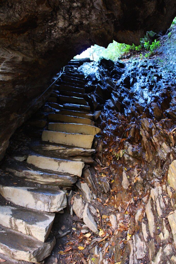
This is the first “wow” moment. Arch Rock isn’t an arch you look at from a distance. You walk through it. A set of steep stone steps, with a steel cable handrail, climbs right up the middle of a narrow opening in the dark slate. Water and frost wore this hole through the rock over thousands of years.
It’s cool, damp and a little dim inside, and it makes a great photo. If you’re hiking with young kids or you’re short on time, this is a perfect place to turn around. The round trip from here is about 2.8 miles.
3. The Climb to Inspiration Point (About Mile 1.4–2)
After Arch Rock, the trail changes. It leaves the creek and starts to climb for real, with more rock steps and a few short switchbacks. The forest opens up, and you start getting peeks at the mountains through the trees. This is where most people start breathing harder.
You’ll pass through a tangle of rhododendron and mountain laurel that locals once called a “hell” (an old word for thickets so dense you couldn’t walk through them). The big slope across the valley, Huggins Hell, is one of these.
4. Inspiration Point (About Mile 1.8–2)
Inspiration Point is a rocky, open spot at about 4,700 feet with your first big, wide-open view. Look across the valley at Little Duck Hawk Ridge, a jagged fin of rock. Can you spot the hole near the top? That’s the “Eye of the Needle,” a small natural window through the ridge. Above you rises Peregrine Peak, where peregrine falcons have nested since they were brought back to the park.
It’s a great spot for a snack break and photos. Stay back from the edges, though, especially when the rock is wet.
5. Alum Cave Bluffs (About Mile 2.2–2.3)
After a final short climb, you reach Alum Cave Bluffs at about 4,950 feet. And here’s the funny part: it isn’t a cave. It’s a huge, curved rock overhang, about 80 feet tall and around 500 feet long, that leans out over the trail like a giant stone awning. You can stand underneath it and stay mostly dry in the rain.
The ground under the bluff is dry, dusty and soft, because rain never reaches it. Look closely at the rock: the crusty, chalky minerals on it are what gave this place its name (more on that in the history section). In winter, long icicles hang from the lip of the bluff, and chunks can break off and fall, so don’t linger right under the edge when it’s icy.
For most hikers, this is the goal. Sit on a rock, eat lunch, enjoy the view back down the valley, then head back the same way. Round trip: about 4.4–4.6 miles.
Alum Cave Trail to Mount LeConte
Past the bluffs, the trail becomes a different hike. The crowds thin out, the climb gets steeper, and the views get bigger. The Alum Cave Trail is the shortest and steepest of the five trails to Mount LeConte, and many hikers say it’s also the most beautiful.
Mount LeConte via Alum Cave Trail: Distance and Difficulty
- Distance: about 5 miles one way to LeConte Lodge, so about 10 miles round trip. Add the walks to High Top and the viewpoints, and most people end up with 11 miles or a bit more.
- Climb: about 2,700–2,800 feet from the trailhead.
- Time: 6–9 hours for most hikers, including breaks.
- Difficulty: strenuous. The hardest part is the first half mile above the bluffs, which is the steepest section of the whole trail.
What the Upper Trail Is Like
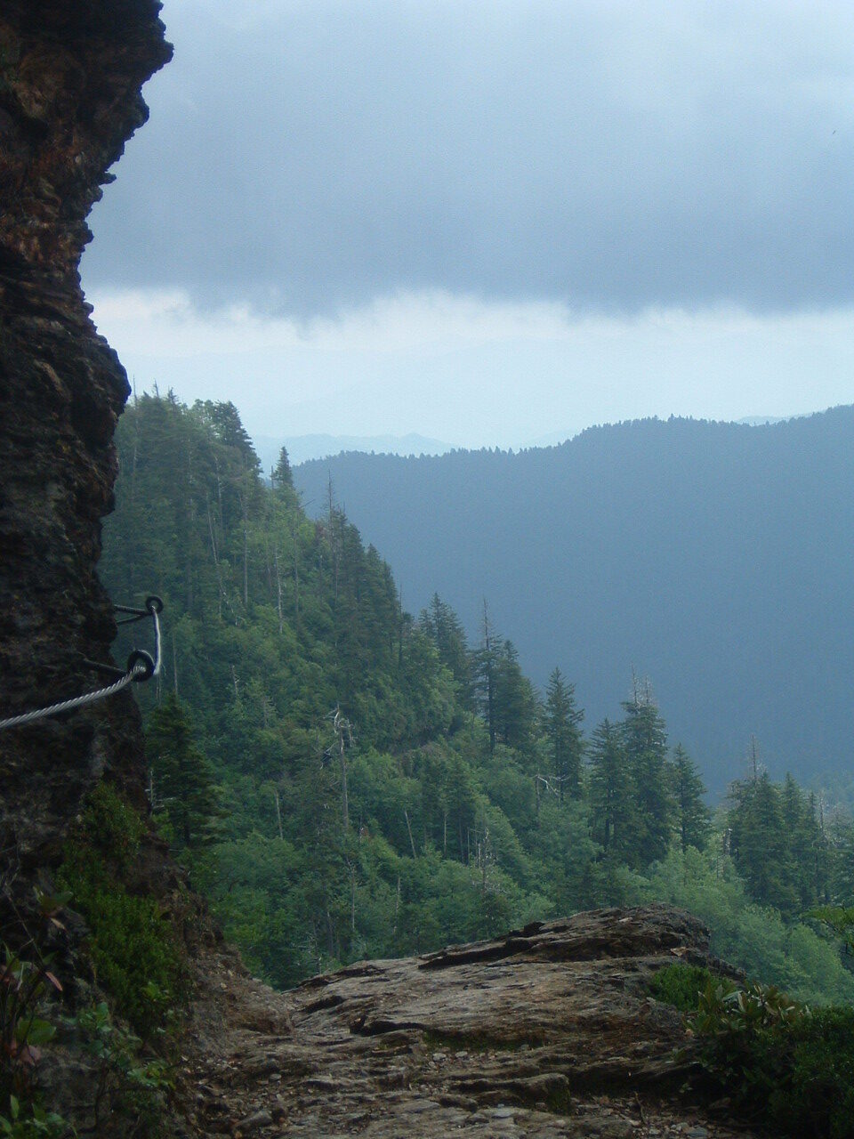
Above the bluffs, the trail climbs onto the side of the mountain. In several places it’s a narrow ledge cut into the rock face, with a drop on one side and steel cables bolted into the rock to hold on to. These sections aren’t technical, but they’re exposed. If you’re nervous about heights, take your time and keep one hand on the cable.
About halfway, you’ll pass Gracie’s Pulpit, a rocky point named for Gracie McNicol, who hiked to LeConte many times, including on her 92nd birthday. From here, you can see four of LeConte’s peaks: West Point, Cliff Tops, High Top and Myrtle Point.
Near 6,000 feet, the forest changes completely. You enter a cool, dark spruce-fir forest that feels more like Canada than Tennessee. You’ll also see many gray, dead Fraser fir trunks. Most were killed by a tiny invasive insect, the balsam woolly adelgid, in past decades. Young firs are now growing back.

At the Top: LeConte Lodge, High Top, Cliff Tops and Myrtle Point
The Alum Cave Trail ends near LeConte Lodge, a cluster of rustic wooden cabins near the summit. It’s the only lodge in the park, and you can only get there on foot. There are no roads, no electricity in the cabins, and supplies arrive by llama train and helicopter. It’s been welcoming hikers since the 1920s.
- Day hikers can buy a sack lunch (about $15) at set times during the season, and “I Hiked It” T-shirts that are sold only on the mountain. Bring cash or a card, and still pack your own food in case they’re sold out.
- Staying overnight requires a reservation, and it’s famously hard to get. The 2026 season (March 23 to late November) is fully booked, though last-minute cancellations do happen. Bookings for 2027 opened in fall 2026.
- High Top (6,593 feet) is the true summit, a short walk past the lodge. It’s in the trees, so the view isn’t great, but there’s a rock pile hikers add to.
- Cliff Tops, a short walk from the lodge, is the classic sunset spot.
- Myrtle Point, a bit farther, is the classic sunrise spot, with views east over endless ridges.
LeConte is the third-tallest peak in the park, and it rises about 5,300 feet from its base near Gatlinburg. That’s one of the biggest base-to-summit rises of any mountain in the eastern United States.
Is the Climb to LeConte Worth It?
For strong hikers, absolutely. The ledges, the spruce-fir forest, the lodge and the views from Cliff Tops make it one of the great hikes of the eastern United States. But don’t feel you’ve “failed” if you stop at the bluffs. The lower half has the trail’s most famous sights. Go to the top only if you start by about 8 a.m., the weather looks good, and you’re comfortable hiking 10+ miles with a lot of climbing.
Alum Cave Trail Difficulty: How Hard Is It?
The trail gets harder the farther you go. Here’s a simple breakdown:
- Trailhead to Arch Rock: easy to moderate. A gentle climb beside the creek, with roots and rocks. Most kids and beginners do fine.
- Arch Rock to the bluffs: moderate. Steeper, rockier and more steps. You’ll stop to catch your breath.
- Bluffs to LeConte: strenuous. Steep, long and exposed in places, with cable sections and loose rock.
Is Alum Cave Trail Good for Beginners?
Yes, for Arch Rock and usually for the bluffs too, if you take your time. The path is easy to follow and there are plenty of places to rest. It’s not paved, though, so wear real shoes. The full LeConte hike is not a good first hike; build up to it. Our hiking for beginners guide covers how to prepare.
Is Alum Cave Trail Good for Kids?
Kids usually love Arch Rock: climbing “through” a mountain feels like an adventure. Active school-age kids can often make it to the bluffs. Watch them closely near the drop-offs at Inspiration Point and on the steps through the arch. The upper trail to LeConte is only for strong, experienced teens. Strollers won’t work anywhere on this trail.
Alum Cave Trail Elevation Gain
| Point | Elevation (approx.) | Climb from trailhead |
|---|---|---|
| Trailhead | 3,830 ft | — |
| Arch Rock | 4,300 ft | About 500 ft |
| Inspiration Point | 4,700 ft | About 900 ft |
| Alum Cave Bluffs | 4,950 ft | About 1,100 ft |
| LeConte Lodge area | 6,400+ ft | About 2,600 ft |
| High Top (summit) | 6,593 ft | About 2,750 ft |
Don’t forget the weather difference. The top of LeConte is often 10–15°F colder than the trailhead, and much colder than Gatlinburg. It can be windy, foggy and wet up there even when town is sunny. Always pack a warm layer, even in summer.
How Long Does the Alum Cave Trail Take?
| Destination | Fast, fit hikers | Average hikers | Families and slow pace |
|---|---|---|---|
| Arch Rock and back | 1–1.5 hours | 1.5–2 hours | 2–2.5 hours |
| Alum Cave Bluffs and back | 2–2.5 hours | 3–3.5 hours | 4–4.5 hours |
| Mount LeConte and back | 5–6 hours | 6–8 hours | 8–9+ hours |
These times include short breaks. Add more for lunch, photos, crowds on the narrow sections, or wet and icy ground. For LeConte, plan to be at the top by about 1 p.m. in fall so you finish before dark.
Best Time to Hike the Alum Cave Trail
By Season
- Spring (April–May): fresh green leaves and wildflowers lower down. Early spring can still bring ice up high, and trails can be muddy.
- Early summer (June): rhododendron and mountain laurel bloom along the creek. Long days help with LeConte.
- Summer (July–August): warm and humid, with frequent afternoon thunderstorms. Start early and get off exposed ledges before storms.
- Fall (late September–October): the most beautiful and the most crowded. Color reaches the high peaks first (early to mid-October) and moves down the mountain later in the month.
- Winter (December–March): quiet, with icicles on the bluffs, but the upper trail is often covered in ice. Newfound Gap Road can close in bad weather.
By Time of Day
Start by 7:30–8 a.m. You’ll get a parking space, enjoy cooler air and miss most of the crowds at Arch Rock and the bluffs. Weekdays are always quieter than weekends.
Hiking Alum Cave Trail in Winter
Winter can be magical here, but it’s a different hike. The cable sections above the bluffs face north and can stay icy for days. The park recommends traction devices like microspikes when there’s ice, and many hikers turn around at the bluffs in winter.
- Check whether Newfound Gap Road is open before you leave; it closes for snow and ice.
- Bring microspikes, warm layers, gloves and a headlamp (days are short).
- Don’t stand under the bluff’s edge when icicles are hanging.
- If the ledges look glazed with ice and you don’t have traction, turn around. It’s not worth it.
Is the Alum Cave Trail Dangerous?
The lower trail is safe for careful hikers. Most problems come from slips, weather and people overestimating how far they can go. Rangers, local rescue teams and even National Guard helicopter crews have helped injured hikers on this trail over the years. Keep these simple rules in mind:
- Watch your feet on wet roots, slick rocks and the steps through Arch Rock.
- Use the cables on the upper ledges, and stay on the trail side.
- Turn around if a thunderstorm moves in, if there’s ice and you have no traction, or if it’s getting late.
- Treat stream water before drinking, or carry all you need.
- Black bears live here. Never feed them, keep at least 150 feet away, and store food in your pack. If a bear comes toward you, stand tall, make noise and back away slowly.
- Tell someone your plan, since there’s little or no cell service.
- In an emergency, call 911 if you have signal, or send someone to the trailhead for help.
What to Bring on the Alum Cave Trail
For Arch Rock or the Bluffs
- 1–2 liters of water per person
- Snacks or lunch
- Hiking shoes or trail runners with good grip
- A light rain jacket (it rains a lot in the Smokies; see our waterproof hiking jacket guide)
- Your printed parking tag on the dashboard
Extra for Mount LeConte
- 2–3 liters of water, or a filter for the streams lower down
- A real lunch and salty snacks
- Warm layer, hat and gloves (it’s much colder on top)
- A headlamp, in case you finish after dark
- Trekking poles for the long descent
- Offline map, first-aid kit and a small power bank
- Microspikes from about November to March
Alum Cave Trail Map and Route
The route is simple and well signed. It’s one trail, out and back:
Trailhead (Newfound Gap Road) → footbridges along Alum Cave Creek → Arch Rock (mile 1.3–1.4) → Inspiration Point (mile 1.8–2) → Alum Cave Bluffs (mile 2.2–2.3) → cable ledges → Gracie’s Pulpit → spruce-fir forest → LeConte Lodge (mile 5) → High Top, Cliff Tops and Myrtle Point.
Near the top, the Alum Cave Trail meets the Rainbow Falls Trail and the Bullhead Trail. Make sure you head down the right one. All three end up in different places, miles apart.
For a map, use the official park trail map (free at visitor centers and online), or download the route in a hiking app before you lose signal.
Other Trails to Mount LeConte
| Trail | One way to the lodge | What it’s like |
|---|---|---|
| Alum Cave Trail | About 5 miles | Shortest and steepest; most scenic and most popular |
| Boulevard Trail | About 8 miles from Newfound Gap | Longer, starts higher, follows a high ridge |
| Rainbow Falls Trail | About 6.5 miles | Passes a tall waterfall; starts near Gatlinburg |
| Trillium Gap Trail | About 6.5–9 miles | Passes Grotto Falls; the llama supply route |
| Bullhead Trail | About 7 miles | Quieter, steady climb |
Some hikers go up Alum Cave and down another trail, using a shuttle or a second car. It’s a fun way to see more of the mountain. Note that Bullhead Trail has had weekday maintenance closures in 2026, so check before planning a route that uses it.
The Story Behind the Name: Alum, Epsom Salts and the Civil War
Why “Alum Cave”? Because people once came here to mine it. The dry rock under the bluff is crusted with minerals that never get washed away by rain.
- 1830s: local farmers bought the land around the bluff and formed the Epsom Salts Manufacturing Company to dig out alum, Epsom salts (magnesium sulfate), saltpeter and other minerals. Alum was used to dye cloth and treat leather; Epsom salts were used as medicine.
- 1840s: the easy-to-reach deposits ran out, and mining slowed.
- Civil War: mining started again for the Confederate army, which wanted saltpeter to make gunpowder.
Today, the bluff is protected, and taking rocks or minerals is not allowed. In the 2010s, park crews and volunteers rebuilt much of the trail: new steps, rock walls, drainage and cables. That’s why it’s in such good shape for how many people walk it.
Alum Cave Trail Pictures: Best Photo Spots
- The creek and footbridges: soft morning light and mossy rocks. A slow shutter makes the water silky.
- Arch Rock: shoot from below, with a friend on the steps for scale.
- Inspiration Point: wide views of Little Duck Hawk Ridge and the “Eye of the Needle.”
- Alum Cave Bluffs: step back and use a wide angle to show how huge the overhang is.
- Cliff Tops at sunset and Myrtle Point at sunrise (only if you’re staying at the lodge or hiking with headlamps).
Please never leave the trail or walk to cliff edges for a photo. It’s the most common way people get hurt.
10 Simple Tips for the Best Alum Cave Hike
- Buy your parking tag the day before.
- Arrive before 8 a.m., especially in October and on weekends.
- Use the trailhead restroom before you start; there’s nothing else until LeConte.
- Pick your turnaround point before you start, and set a “turn-around time” for LeConte.
- Go slowly after Arch Rock. The climb starts there.
- Pack a jacket even on a warm day.
- Eat lunch at the bluffs, where there’s shelter from rain.
- Take small steps going down; most slips happen on the way back.
- Let faster hikers pass on narrow sections, and give uphill hikers the right of way.
- Leave no trace: pack out all trash, and don’t carve or chip the rock.
Sample Plans for Your Hike
Short Morning: Arch Rock (2.8 Miles)
Start at 8 a.m., reach Arch Rock by about 8:45, play by the creek on the way back, and be at the car by 10. Then drive up to Newfound Gap for the big roadside view.
Half Day: Alum Cave Bluffs (About 4.5 Miles)
Start at 8 a.m., Arch Rock at 8:45, Inspiration Point at 9:30, the bluffs by about 10. Have a snack, head down, and you’re back by noon or 12:30 with the afternoon free for Gatlinburg.
Full Day: Mount LeConte (About 11 Miles)
Start at 7:30 a.m., the bluffs by 9, LeConte Lodge by about 12, lunch and a visit to Cliff Tops, then start down by 1:30. Plan to be back at the car around 4:30–5 p.m. Bring a headlamp just in case.
What to Do Near the Alum Cave Trail
- Newfound Gap: about 15 minutes up the road; stand with one foot in Tennessee and one in North Carolina, with huge views.
- Kuwohi (formerly Clingmans Dome): the highest point in the park, with an observation tower. The road is usually closed from December to March. See our Clingmans Dome hike difficulty guide.
- Chimney Tops Trail: a short, very steep hike just down the road.
- Sugarlands Visitor Center: exhibits, maps, parking tags and restrooms.
- Gatlinburg: food, a well-earned dessert and places to stay.
For more ideas, see our guide to the best things to do in Great Smoky Mountains National Park.
Alum Cave Trail FAQs
How long is the Alum Cave Trail?
The whole trail is about 5 miles one way, to LeConte Lodge. Most people hike to Arch Rock (2.8 miles round trip) or Alum Cave Bluffs (4.4–4.6 miles round trip). Going all the way to Mount LeConte is about 10–11 miles round trip.
How hard is the Alum Cave Trail?
Easy to moderate to Arch Rock, moderate to the bluffs and strenuous to Mount LeConte.
How long does it take to hike to Alum Cave Bluffs?
About 3–4 hours round trip for most people, including breaks.
How long does it take to hike Mount LeConte via the Alum Cave Trail?
Plan 6–9 hours round trip. Fast hikers can do it in about 5–6.
What is the elevation gain on the Alum Cave Trail?
About 1,100 feet to Alum Cave Bluffs and about 2,700–2,800 feet to Mount LeConte.
Where do you park for the Alum Cave Trail?
In the two signed lots at the Alum Cave Trailhead on Newfound Gap Road (US 441), about 8.5 miles from Sugarlands Visitor Center. Arrive early; they fill fast.
Do you need a permit or reservation?
No permit or reservation for day hiking. You do need a park parking tag ($5 a day) if you park longer than 15 minutes.
Is Alum Cave a real cave?
No. It’s a huge overhanging cliff, about 80 feet tall, not a cave you walk into.
How far is Arch Rock on the Alum Cave Trail?
About 1.3–1.4 miles from the trailhead.
How far is Inspiration Point?
About 1.8–2 miles from the trailhead, a little before the bluffs.
Are dogs allowed on the Alum Cave Trail?
No. Dogs aren’t allowed on most trails in Great Smoky Mountains National Park, including this one.
Is the Alum Cave Trail open in winter?
It’s usually open, but the upper trail can be icy, and Newfound Gap Road sometimes closes for snow and ice. Bring microspikes and check conditions.
Can you buy food at the top of Mount LeConte?
During the lodge’s season (late March to late November), day hikers can usually buy a sack lunch and souvenirs. Still bring your own food.
Is the Alum Cave Trail worth it if I don’t go to the top?
Yes. The hike to the bluffs includes the creek, Arch Rock, Inspiration Point and the bluffs themselves, the trail’s most famous sights.
Is the Alum Cave Trail Worth It?
Yes, and that’s true whether you walk 3 miles or 11. Few trails in the eastern United States pack this much into one route: a mountain creek, a rock arch you climb through, a big lookout, a cliff you can stand under and, for those who keep going, a mountaintop lodge with some of the best sunsets in the Smokies.
Get your parking tag the night before, arrive early, pick a turnaround point that fits your day, and bring a jacket. Do that, and you’ll see why so many hikers call Alum Cave their favorite trail in the Smokies.