
Linville Falls doesn’t just fall. It twists. The Linville River slides over a wide upper ledge, squeezes into a slot of rock barely wider than a hallway, then bursts out and plunges into a deep pool at the head of one of the wildest canyons in the eastern United States.
It’s often called the most photographed waterfall in North Carolina. And the best part is how many ways there are to see it: from right above the upper falls, from rocky ledges looking across the gorge, or from the edge of the plunge pool below.
This guide covers the Linville Falls trail and waterfall in simple, practical terms: every trail and overlook with its distance, which one to pick, how hard each is, parking, what’s open in 2026 after Hurricane Helene, the best photo spots and tips for your visit.
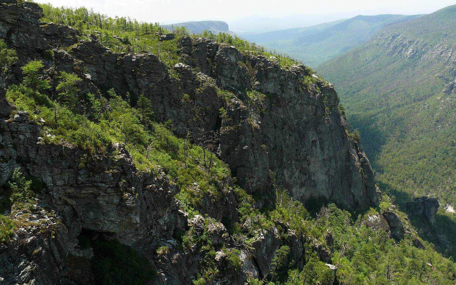
Cover photo: Linville Gorge Wilderness, the canyon that begins at Linville Falls. Photo: Ken Thomas / Wikimedia Commons (public domain)
Linville Falls Trail: The Short Answer
Linville Falls is at Milepost 316.4 on the Blue Ridge Parkway in western North Carolina. The most popular hike is the Erwin’s View Trail: 1.6 miles round trip, moderate, with four overlooks (Upper Falls, Chimney View, Gorge View and Erwin’s View). The Plunge Basin Overlook Trail is about 1 mile round trip but strenuous. As of late October 2026, the Erwin’s View and Plunge Basin trails are open after Hurricane Helene repairs, but part of the Linville Gorge Trail down to the river is still closed, the visitor center has been removed, and the campground is closed. Parking is free. Swimming and climbing on the rocks are not allowed.
Is Linville Falls Open in 2026? (Hurricane Helene Update)
Hurricane Helene hit this area very hard in September 2024. Thousands of trees came down in the gorge, and the falls area stayed closed for a long time. Here’s where things stand as of late October 2026:
| Area | Status (late October 2026) |
|---|---|
| Linville Falls Spur Road and main parking lot | Open |
| Erwin’s View Trail (all four overlooks) | Open |
| Plunge Basin Overlook Trail | Open (recently reopened) |
| Dugger’s Creek Falls loop | Open, with visible storm damage |
| Forest Service trail from Old NC 105 | Open (reopened June 2026) |
| Linville Gorge Trail down to the river | Partly closed; follow posted signs |
| Visitor center | Removed after storm damage; rebuild planned by end of 2027 |
| Restrooms | Portable toilets only |
| Campground and picnic area | Closed |
Important: parts of the Blue Ridge Parkway south of Linville Falls have also had long closures. If you’re coming from Asheville, check the Parkway’s road status page before relying on it. You may need to use I-40 and US 221 instead.
Things change quickly during storm recovery, so check the National Park Service’s Blue Ridge Parkway pages, and obey every closure sign at the trailhead. Older blogs and maps written before Helene can be out of date.
Linville Falls at a Glance
| Detail | Information |
|---|---|
| Location | Blue Ridge Parkway, Milepost 316.4, Burke County, North Carolina |
| Managed by | National Park Service (Parkway side) and U.S. Forest Service (Old NC 105 side) |
| Best hike | Erwin’s View Trail, 1.6 miles round trip |
| Difficulty | Moderate (Erwin’s View); strenuous (Plunge Basin, Linville Gorge) |
| Waterfall | Upper falls plus a narrow chute and a 45-foot main plunge; about 150 feet of drops in total |
| Trail surface | Dirt, rocks, roots and wooden steps |
| Cost | Free (no entrance or parking fee) |
| Reservation | Not needed |
| Dogs | Allowed on a leash (6 feet or shorter) |
| Swimming and climbing on rocks | Not allowed |
| Best time | Mid-October for fall color; spring for strong water flow |
Where Is Linville Falls?
Linville Falls is in the Blue Ridge Mountains of western North Carolina, along the Blue Ridge Parkway between Blowing Rock and Asheville. The small town of Linville Falls is just up the road.
The falls are the start of Linville Gorge, a rugged canyon about 12 miles long, often called the “Grand Canyon of the East.” Below the falls, the river cuts through a protected wilderness area with steep cliffs on both sides.
- From Blowing Rock: about 45 minutes on the Parkway
- From Boone: about 50 minutes
- From Marion: about 30 minutes via US 221
- From Asheville: about 1 hour 15 minutes to 1.5 hours, depending on Parkway closures
How to Get There and Where to Park
Main Parking Lot (Blue Ridge Parkway Side)
- Drive to Milepost 316.4 on the Blue Ridge Parkway.
- Turn onto the Linville Falls Spur Road.
- Follow it about 1.5 miles to the end, where you’ll find the main paved parking lot and the trailheads.
Parking is free. The lot fills on fall weekends and summer holidays, so try to arrive before 10 a.m. Don’t park on the road shoulder.
Milepost vs. Hiking Distance
“Milepost 316.4” is just a road marker on the Parkway, not a hiking distance. It tells you where to turn. Your hike starts at the parking lot at the end of the spur road.
Forest Service Parking (Old NC 105)
There’s a second way in from the west side. A smaller gravel lot on Old NC 105 (Kistler Memorial Highway), run by the U.S. Forest Service, has a short trail toward the upper falls area. It reopened in June 2026. It’s handy if the Parkway is closed or if you’re heading on to Wiseman’s View in the gorge. Expect fewer facilities and a rough gravel road.
Which Linville Falls Trail Should You Hike?
There are two main trails from the parking lot, and they go to opposite sides of the river. Here’s a simple comparison.
| Trail or overlook | Round trip | Difficulty | Best for |
|---|---|---|---|
| Upper Falls Overlook | About 1 mile | Easy–moderate | A short walk to see the upper falls and the chute |
| Chimney View | About 1.4 miles | Moderate | The classic photo of the main falls |
| Erwin’s View (all 4 overlooks) | 1.6 miles | Moderate | Most visitors; the best overall hike |
| Plunge Basin Overlook | About 1 mile | Strenuous | A closer, lower view of the main plunge |
| Linville Gorge Trail (to the river) | About 1.4 miles | Strenuous | The base of the falls (part closed in 2026) |
| Dugger’s Creek Falls loop | About 0.3 mile | Moderate | A quick bonus waterfall by the parking lot |
Our simple advice: if you only do one, do Erwin’s View. It’s the right mix of effort and reward, and you’ll see the falls from four different angles. If you still have energy afterward and you’re sure-footed, add Plunge Basin.
Erwin’s View Trail: Overlook by Overlook
The Erwin’s View Trail starts at the parking lot, crosses the Linville River on a footbridge and climbs gently through a forest of hemlock, white pine and rhododendron on the east side of the river. It’s 0.8 mile one way, 1.6 miles round trip, and most people take 1 to 1.5 hours with stops.
1. Upper Falls Overlook (About 0.5 Mile)
The first overlook puts you right above the river. You watch the water spill over the wide upper falls, then suddenly squeeze into a narrow, deep slot in the rock. It’s loud and powerful, and you’re closer to the water here than anywhere else on the trail.
This is a good turnaround point if you want a very short walk. But don’t climb past the railings. People have died after slipping on the rocks around the upper falls.
2. Chimney View (About 0.7 Mile)
After a steeper climb, you reach Chimney View. This is the famous one. From a rocky ledge, you look straight across at the main falls as the river shoots out of the slot and drops about 45 feet into the plunge pool, with the gorge opening up below.
The name comes from the tall, chimney-shaped rock columns nearby. There are upper and lower viewing spots here, and both are worth a look.

3. Gorge View
A little farther on, Gorge View turns your attention away from the falls and down the canyon. You see the river winding into Linville Gorge between steep, forested walls. It’s a great spot to understand just how big and wild this place is.
4. Erwin’s View (About 0.8 Mile)
The last and highest overlook is Erwin’s View. From here, the falls look smaller, a white ribbon in the trees, but you get the widest view: the falls, the gorge and the mountains all together. In fall, this is the classic “postcard” shot.
Then you head back the same way to the parking lot.
Plunge Basin Overlook Trail: Short but Harder
The Plunge Basin Overlook Trail starts from the same parking area but goes along the west side of the river. It’s only about 1 mile round trip, but it’s rated strenuous because it’s steep and rocky, with rough steps and roots.
The reward is a lower, closer view of the main falls pouring into the plunge pool, framed by cliffs. It feels much more “inside” the gorge than the Erwin’s View overlooks.
Be careful here. The trail reopened recently after storm repairs, and on October 24, 2026, a hiker was injured in a fall on it and had to be carried out by rescue crews. Wear good shoes, take your time on the rocks and stay on the trail.
Linville Gorge Trail: Can You Hike to the Bottom of the Falls?
Normally, the Linville Gorge Trail branches off the Plunge Basin trail and drops steeply down to the river at the base of the falls, about 1.4 miles round trip. It’s the only way to stand beside the plunge pool.
In 2026, part of this trail is still closed because of Helene damage. Respect the closure signs. Don’t try to scramble down off-trail; the slopes are steep and unstable, and the river is dangerous.
Even when it’s open, the area at the base is not a swimming hole. Swimming and wading in the river near the falls are not allowed. Strong currents and hidden undercuts have caused drownings here.
Bonus: Dugger’s Creek Falls
Right by the parking lot, a tiny loop trail (about 0.3 mile) leads to Dugger’s Creek Falls, a small waterfall in a mossy little gorge with a footbridge above it. Helene left visible damage here, and the bridge is now the best viewpoint, but it’s a nice five-minute add-on, especially for kids.
How Hard Is the Linville Falls Hike?
- Erwin’s View Trail: moderate. A steady climb with some steps, roots and rocks. Most people, including families, can do it at an easy pace.
- Plunge Basin: strenuous. Short, but steep and rocky, with uneven footing.
- Linville Gorge Trail: strenuous. A steep descent to the river, and a steep climb back out.
Is Linville Falls Good for Beginners and Kids?
Yes, on the Erwin’s View Trail. It’s short, well marked and has plenty of places to stop. Hold young children’s hands at the overlooks, as some have steep drops beyond the railings. Plunge Basin is better for older kids who are steady on rocks.
Is It Wheelchair or Stroller Accessible?
No. All the trails have natural, uneven surfaces, steps and roots. A baby carrier works much better than a stroller.
How Long Does It Take?
| Hike | Typical time |
|---|---|
| Upper Falls Overlook and back | 30–45 minutes |
| Erwin’s View Trail (all overlooks) | 1–1.5 hours |
| Plunge Basin Overlook | 45 minutes–1 hour |
| Erwin’s View + Plunge Basin + Dugger’s Creek | 2.5–3 hours |
Linville Falls Trail Map: How It All Fits Together
Picture the river running north to south through the middle, with the parking lot near the bottom of the spur road:
- East side (across the footbridge): Erwin’s View Trail, climbing past Upper Falls, Chimney View, Gorge View and Erwin’s View.
- West side (same side as the lot): Plunge Basin Overlook Trail, with the Linville Gorge Trail branching down to the river.
- By the parking lot: the short Dugger’s Creek loop.
- Far west side: the Forest Service trailhead on Old NC 105.
The National Park Service publishes an official Linville Falls trail map on its Blue Ridge Parkway website. Download it before you go, since cell service is weak, and compare it with the closure signs at the trailhead.
Best Spots for Linville Falls Photos
- Chimney View: the classic shot of the main falls and plunge pool. A wide-angle lens helps.
- Erwin’s View: the falls inside the gorge, especially beautiful with fall color.
- Upper Falls Overlook: close-up shots of the water racing through the slot.
- Plunge Basin: a dramatic, lower angle on the main drop.
Light tips: the gorge is deep, so harsh midday sun creates strong shadows. Cloudy days and early morning often give the softest light on the water. Never step past railings or onto wet rocks for a better angle.
Best Time to Visit Linville Falls
- Spring (April–May): the strongest water flow, fresh green leaves and wildflowers. Trails can be muddy.
- Early summer (June): rhododendron and mountain laurel bloom along the trails.
- Summer (July–August): shady, green and busy, with afternoon thunderstorms. Water can be lower in dry spells.
- Fall (October): the most popular time. Color usually peaks around mid-October, with the gorge glowing red and gold. Expect full parking lots on weekends.
- Winter (December–March): quiet, with icicles on the cliffs and views through bare trees. Parkway sections often close for ice and snow, so check road status.
Best time of day: before 10 a.m. for parking and quiet overlooks.
Safety at Linville Falls
This is a beautiful place, but the river and cliffs are dangerous. Over the years, several people have died here after slipping on rocks or entering the water.
- Stay behind railings and on the marked trails.
- Don’t climb on the rocks near the falls. It’s not allowed, and wet rock here is extremely slick.
- Don’t swim or wade. The current is much stronger than it looks.
- Obey Helene closure signs. Damaged areas can have loose trees, slides and unstable ground.
- Keep dogs leashed and kids close at overlooks.
- In an emergency, call 911. Cell service can be spotty in the gorge.
What to Bring
- Shoes with good grip; the trails have roots, rocks and wet steps.
- Water and snacks. With the visitor center gone, there’s no reliable drinking water or store.
- A light rain jacket (see our waterproof hiking jacket guide).
- A downloaded map of the trails.
- A camera or phone; you’ll want it.
- Trekking poles if you’re doing Plunge Basin.
Common Mistakes to Avoid
- Using old, pre-Helene guides that say every trail is open.
- Thinking all trails are equally easy. Plunge Basin is much harder than Erwin’s View.
- Driving the Parkway from Asheville without checking for closures.
- Expecting the visitor center, restrooms and water to be there as before.
- Climbing past railings for a photo.
A Little History
The Cherokee called the river Eeseeoh, often translated as “river of many cliffs,” a perfect name for this canyon. The falls and gorge were later named for William Linville, an 18th-century explorer who died in the area in 1766.
In the early 1900s, the land around the falls was privately owned. In 1952, John D. Rockefeller Jr. provided the money for the National Park Service to buy it, about 1,100 acres in all, so it could be protected and opened to everyone as part of the Blue Ridge Parkway.
The falls themselves have changed, too. The upper part of the main plunge once dropped as a separate fall, but floods wore it down, and it collapsed into the lower falls, creating the long, narrow chute you see today.

What to Do Near Linville Falls
- Wiseman’s View: a famous overlook into Linville Gorge, reached by the gravel Old NC 105. Check for Helene-related closures.
- Linville Gorge Wilderness: tough, rugged trails for experienced hikers. Many have reopened since 2025, but rescue times are longer than before, so go prepared.
- Linville Caverns: a small show cave a few miles south on US 221.
- Grandfather Mountain and the Linn Cove Viaduct: about 30 minutes north on the Parkway.
- Blowing Rock and Boone: mountain towns with food and places to stay.
Planning more of a North Carolina mountain trip? See our guide to the best things to do in Asheville and our Great Smoky Mountains guide.
Sample Half-Day Plan
- 9:00 a.m.: Arrive at the main parking lot (check the Parkway status first).
- 9:10 a.m.: Hike the Erwin’s View Trail to all four overlooks.
- 10:30 a.m.: Back at the lot. Quick walk to Dugger’s Creek Falls.
- 10:45 a.m.: If you’re feeling steady, hike to Plunge Basin Overlook.
- 12:00 p.m.: Lunch in Linville Falls village or drive on to Blowing Rock.
Linville Falls Trail FAQs
How long is the Linville Falls trail?
The main Erwin’s View Trail is 1.6 miles round trip (0.8 mile each way). Plunge Basin is about 1 mile round trip, and the Linville Gorge Trail is about 1.4 miles round trip.
How far is Erwin’s View?
About 0.8 mile from the trailhead, so 1.6 miles round trip, passing Upper Falls, Chimney View and Gorge View on the way.
Is Linville Falls open after Hurricane Helene?
Mostly. As of late October 2026, the Erwin’s View and Plunge Basin trails are open. Part of the Linville Gorge Trail, the campground and picnic area are still closed, and the visitor center has been removed.
Is the Linville Falls hike hard?
Erwin’s View is moderate and fine for most people. Plunge Basin and the Linville Gorge Trail are short but strenuous.
Which Linville Falls overlook is best?
Chimney View gives the classic close view of the main falls. Erwin’s View gives the widest view of the falls and gorge together.
Can you hike to the bottom of Linville Falls?
Normally yes, via the Linville Gorge Trail, but part of that route is still closed in 2026 because of Helene damage. Follow posted signs.
Can you swim at Linville Falls?
No. Swimming, wading and climbing on the rocks near the falls are not allowed, and people have died here.
Is there a fee to visit Linville Falls?
No. Parking and the trails are free, and no reservation is needed.
Are dogs allowed at Linville Falls?
Yes, on a leash no longer than 6 feet.
What milepost is Linville Falls on the Blue Ridge Parkway?
Milepost 316.4. Turn onto the Linville Falls Spur Road and drive about 1.5 miles to the parking lot.
How tall is Linville Falls?
The main plunge is about 45 feet, and all the drops together add up to roughly 150 feet.
Is the Linville Falls Trail Worth It?
Yes. In just 1.6 miles, the Erwin’s View Trail shows you a powerful waterfall from four very different angles, plus a view into one of the deepest gorges in the East. Few short hikes on the Blue Ridge Parkway give you this much.
Check the Helene status and Parkway closures before you go, wear good shoes, stay behind the railings and arrive early. Then take your time at Chimney View. It’s one of those views that’s worth standing still for.