
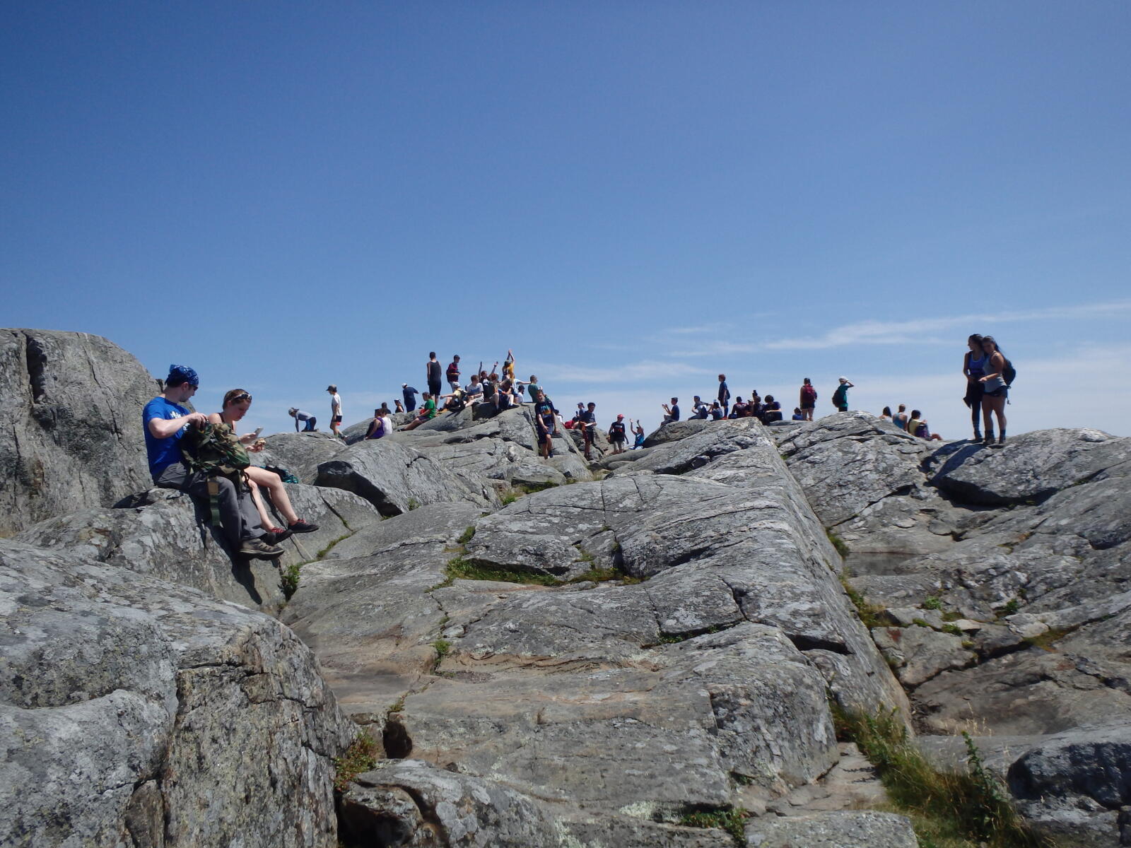
Mount Monadnock isn’t tall. At 3,165 feet it’s barely half the height of Mount Washington. But it stands all alone above the rolling hills of southern New Hampshire, nearly 1,000 feet higher than anything else within 30 miles, and its bare rock summit gives you a view over six states on a clear day. That’s why it’s often called one of the most-climbed mountains in the world, with around 125,000 hikers a year.
Most of them start on the White Dot Trail. It’s the shortest, steepest way to the top: about 2 miles from the park headquarters, climbing roughly 1,800 feet through forest, up rock ledges and over open slabs to the summit. It’s short, but it’s no walk in the park.
This guide covers everything: parking reservations and fees (and which lot to book), the trail map, a section-by-section walk-through, the White Dot vs. White Cross question, summit views, difficulty and timing, seasons, what to pack, the no-dogs rule, camping and a few great stories about the mountain.
Cover photo: hikers on the summit of Mount Monadnock. Photo: NPS
Hiking in November? Clocks went back on November 1, so the sun now sets around 4:30 p.m. in Jaffrey. Start by 10 a.m. at the latest. Expect frost, ice and maybe early snow on the upper rock, and carry microspikes from now through spring. Park headquarters stays open all winter, but services at some trailheads are limited from November through April.
White Dot Trail: The Short Answer
The White Dot Trail is the most direct route up Mount Monadnock: about 2 miles one way (4 miles round trip) from Monadnock State Park Headquarters at 169 Poole Road, Jaffrey, NH, with about 1,800 feet of climbing. It’s steep and rocky, with hand-and-foot scrambling near the top. Plan 3.5–5 hours round trip. Most hikers go up White Dot and down the slightly gentler White Cross Trail. Book a $15 parking reservation for the Headquarters lot ahead of time, and leave your dog at home, because pets aren’t allowed.
White Dot Trail: Quick Facts
| Detail | Information |
|---|---|
| Location | Monadnock State Park, Jaffrey, New Hampshire |
| Trailhead | Park Headquarters, 169 Poole Road, Jaffrey, NH 03452 |
| Distance | About 2 miles one way; about 4 miles round trip |
| Up White Dot, down White Cross | About 4–4.2 miles |
| Elevation gain | About 1,700–1,800 feet |
| Summit | 3,165 feet |
| Difficulty | Strenuous; steep rock scrambles |
| Time | About 2 hours up; 3.5–5 hours round trip |
| Parking | $15 per vehicle (up to 6 people) + $1 online fee; reservation strongly recommended |
| Dogs | Not allowed anywhere in the park |
| Water on trail | None; carry all you need |
| Blazes | White painted dots on rocks and trees |
Where Is the White Dot Trail?
Mount Monadnock rises in the town of Jaffrey in southwestern New Hampshire, about 62 miles northwest of Boston. The White Dot Trail starts at Monadnock State Park Headquarters on the southeast side of the mountain, off Route 124.
| Driving from | Approx. time |
|---|---|
| Keene, NH | 30 minutes |
| Manchester, NH | 1 hour 10 minutes |
| Worcester, MA | 1 hour 10 minutes |
| Boston, MA | 1 hour 45 minutes to 2 hours |
| Hartford, CT | 2 hours |
White Dot Trail Parking: Reservations, Fees and Which Lot
This is where many first-timers go wrong. Monadnock has several entrances, and only one puts you at the White Dot Trail.
| Parking area | Address | Main trails | Good for White Dot? |
|---|---|---|---|
| Park Headquarters | 169 Poole Road, Jaffrey | White Dot, White Cross | Yes, book this one |
| Old Toll Road | 9 Halfway House Road, Jaffrey | White Arrow | No direct access to White Dot |
| Gilson Pond | 585 Dublin Road, Jaffrey | Birchtoft and longer routes | No |
- Cost: $15 per vehicle (up to six people), plus a $1 online reservation fee. NH residents 65 and older don’t pay the parking fee (just the $1 booking fee).
- Reserve: on the NH State Parks website, up to 30 days ahead and until 5 p.m. on the day of your visit. Choose “Monadnock HQ.”
- No reservation? A few walk-up spots are held on a first-come basis, but when the lot is full, you’ll be turned away. Weekends from April through November often sell out.
- Don’t park on the road and walk in. Roadside parking near the entrances isn’t allowed and gets ticketed.
At Headquarters you’ll find flush toilets, a park store, picnic tables and staff who can tell you about trail conditions. Use the restroom here; there’s nothing on the mountain.
White Dot Trail Map and Route
The White Dot and White Cross trails run side by side up the southeast face of the mountain. They share the start and the very top, and split in the middle.
| Point on the trail | Approx. miles from Headquarters | What happens |
|---|---|---|
| Headquarters | 0 | Wide, easy path through the woods |
| Lower junction with White Cross | About 0.6 | Trails split; follow the white dots for the steeper, more direct route |
| Steep middle section | About 0.8–1.6 | Rock steps, ledges and scrambles |
| Upper junction with White Cross | About 1.6–1.7 | Trails rejoin; about 0.3 miles to go |
| Summit | About 2 | Bare rock, 360-degree views |
Download the official Monadnock hiking map from NH State Parks (updated March 2026) before you go, and screenshot it. Cell service on the mountain is spotty, and dozens of trails cross near the top.
Hiking the White Dot Trail: Section by Section
1. The Easy Start (0–0.6 Miles)
From the Headquarters lot, follow the signs past the visitor area onto a wide, well-worn path through hardwood forest. It climbs gently, with roots and rocks underfoot. Watch for the white dots painted on trees and rocks. Enjoy this part; it’s the easiest walking you’ll do all day.
2. The Split and the Steep Middle (0.6–1.6 Miles)
At the first junction, White Cross branches off and White Dot heads straight up. Things change fast. The trail becomes a rough staircase of boulders and roots, then turns into steep rock ledges where you’ll step high and sometimes use your hands. There are short stretches of open slab with your first views back over the forest and lakes.
This is the hardest part of the hike. Take it slow, look for the white dots, and test your footing on wet or leaf-covered rock.
3. Above the Trees (1.6–1.9 Miles)
The trees shrink to wind-bent spruce, then mostly give way to open rock. White Cross joins back in here. The summit is right in front of you, a big dome of gray rock. The last stretch climbs steep, open slabs, following dots and rock cairns. Watch out: this section is very slick when wet or icy, and fog can make it hard to see the next marker.
4. The Summit (2 Miles)
You top out on a wide, bare summit of ancient schist and quartzite, with a survey marker in the rock and views all around. Find a spot out of the wind, eat, and look for the old names carved into the rock by early hikers (the oldest dates to 1801).
Before you head down, find the white dot and white cross markers for your return route. Many trails leave the summit in different directions, and it’s easy to drop down the wrong side of the mountain, especially in fog.

Mount Monadnock Summit Views
Because Monadnock stands alone, the summit view is huge for a mountain its size. On a clear day you look out over a patchwork of forest, farms, lakes and small towns, with lines of blue hills fading into the distance.
- All six New England states can be seen on the clearest days.
- The Boston skyline, about 60 miles southeast, shows up as a faint line on very clear days, especially in fall and winter.
- The White Mountains rise far to the north, and Vermont’s Green Mountains to the west.
- Close by: Pack Monadnock to the east, dozens of ponds below, and in October, a sea of red and orange.
Why is the summit bare? It wasn’t always. Monadnock was once covered in red spruce. Around 1800, settlers burned the lower slopes for pasture, and between 1810 and 1820 farmers set more fires, believing wolves were hiding in fallen trees. The fires burned for weeks and destroyed the soil on the upper mountain. That’s why the top is open rock today, far below the natural tree line of similar peaks.
Photo tip: clear, crisp days after a cold front give the longest views. Summer haze often hides the far horizon.
White Dot vs. White Cross: Which Should You Take?
| Feature | White Dot | White Cross |
|---|---|---|
| Distance to summit | About 2 miles | About 2.2 miles |
| Steepness | Steepest and most direct | A bit gentler overall, with some steep spots |
| Scrambling | More, especially in the middle | Less, but still rocky |
| Best for | Going up | Coming down |
| Start | Park Headquarters | Park Headquarters |
The classic plan: up White Dot, down White Cross. Climbing the steep ledges is safer and easier than coming down them, and you see different scenery on the way back. The full loop is about 4–4.2 miles. Just remember that both trails share the steep final section near the summit, so that part has to be descended either way.
Want something gentler? The White Arrow Trail from the Old Toll Road entrance is usually called the easiest route to the top (about 2.3 miles), but you’ll need a reservation for that lot instead.
How Hard Is the White Dot Trail?
All trails on Monadnock are rated strenuous, and White Dot is the steepest of the main ones. You climb about 1,800 feet in 2 miles, most of it in the second mile.
- Scrambling: Yes. You’ll use your hands on steep ledges. No ropes or climbing skills are needed in good weather.
- Beginners: Fit beginners do it all the time, but go slow, wear good shoes and pick a dry day. Our hiking for beginners guide helps.
- The descent: Often harder than the climb on tired legs, which is why most people come down White Cross.
- Fear of heights: There’s no cliff-edge exposure, but the steep slabs near the top can feel airy.
| Hiker | Up | Round trip with summit break |
|---|---|---|
| Fast, experienced | About 1–1.25 hours | 2.5–3 hours |
| Average pace | About 1.5–2 hours | 3.5–4.5 hours |
| Families or first-timers | 2–2.5 hours | 4.5–6 hours |
Best Time to Hike Mount Monadnock
| Season | What to expect |
|---|---|
| Spring (April–May) | Ice can linger on the upper trail well into May. Muddy lower trail, black flies in late May. Bring traction early in the season. |
| Summer (June–August) | Long days and busy weekends. Hot and sunny on the open rock above 2,000 feet. Watch for afternoon thunderstorms; get off the summit if you hear thunder. |
| Fall (September–October) | The favorite season: cool air, clear views and peak foliage, usually around early to mid-October. Reservations sell out fast. |
| Late fall and winter (November–March) | Short days, ice, snow and strong winds on top. Microspikes are a must; snowshoes after big storms. For prepared, experienced hikers only. |
Best time of day: Start early, especially on weekends. You’ll get a quieter trail and more time on top. Weekday mornings are the calmest of all.
Weather and Safety
The summit is open rock with no shelter. It’s often windier and 10–15°F colder than the parking lot. Check the forecast for Jaffrey and watch for wind, rain, thunderstorms and freezing temperatures.
- Thunderstorms: The bare summit is a lightning target. Turn around if storms are forecast or building.
- Wet rock: Rain makes the slabs very slippery. On rainy days, consider White Cross both ways, or another hike.
- Fog: Stick to the white markers. Don’t wander between cairns guessing.
- No water on the mountain: Dehydration and heat exhaustion are common summer problems.
- Daylight: Carry a headlamp, especially from October onward.
What to Pack
- Hiking boots or shoes with sticky rubber soles for the rock slabs
- 1.5–2 liters of water per person, more in summer
- Snacks or lunch for the summit
- Wind and rain jacket, even on sunny days (see our waterproof hiking jacket guide)
- Warm layer, hat and gloves from September to May
- Microspikes from November to April
- Trekking poles for the descent, stowed on the scrambles (see budget trekking poles)
- Offline map, headlamp and a small first-aid kit
Are Dogs Allowed on Mount Monadnock?
No. Pets aren’t allowed anywhere in Monadnock State Park, on any trail, in any season. The rule protects the fragile summit plants and wildlife. Rangers do enforce it, so don’t bring your dog to the trailhead. (Service animals follow separate rules.) If you want a dog-friendly mountain nearby, check the rules for other local peaks before you go.
Hiking Monadnock With Kids
Lots of New England kids climb Monadnock as their first “real” mountain, and school and camp groups go up all the time. Kids often love the scrambling. But it’s a long, steep day for small legs. Go on a dry day, bring plenty of snacks, take breaks, and set a turnaround time. White Cross is a better way down with children.
Camping Near the White Dot Trail
- Headquarters Campground: right by the White Dot trailhead, perfect for an early start. It’s open year-round, with first-come, first-served sites in winter.
- Gilson Pond Campground: open in the warmer months, on the east side of the park, near other trails.
- No camping on the mountain outside these campgrounds.
- Lodging: inns and B&Bs in Jaffrey, Peterborough and Keene. Book early for foliage weekends.
A Little Monadnock History
- The name: “Monadnock” likely comes from an Abenaki word meaning “smooth mountain” or “isolated mountain.” Geologists now use “monadnock” for any lone mountain that stands above worn-down land around it.
- First recorded climb: 1725, by Captain Samuel Willard and his rangers.
- Famous fans: Ralph Waldo Emerson wrote his poem “Monadnoc” about it, and Henry David Thoreau climbed it four times and studied its plants.
- Protected: The Society for the Protection of New Hampshire Forests began buying land here in 1915, and the mountain became a National Natural Landmark in 1987.
- Record holders: One local hiker climbed it every day for 2,850 days in a row.
A Simple Day Plan
- Arrive in your reserved time: check in, use the restroom and look at the trail board.
- Hike up White Dot: easy first half-mile, then steady through the steep middle.
- Summit break: lunch out of the wind, photos, and find your way-down markers.
- Descend White Cross: slow and careful on the top slabs.
- After: grab food in Jaffrey or Peterborough, or drive Route 124 for a classic view back at the mountain.
Common Mistakes to Avoid
- Booking the Old Toll Road lot when you want White Dot.
- Showing up on a fall weekend without a reservation.
- Bringing a dog. It’s not allowed.
- Wearing sneakers with worn soles on wet rock.
- Coming down the wrong trail from the summit in fog.
- Starting too late in fall, when it gets dark before 5 p.m.
Mount Monadnock White Dot Trail FAQs
How long is the White Dot Trail?
About 2 miles one way from Park Headquarters to the summit, or about 4 miles round trip.
How long does it take to hike?
Most people take about 2 hours up and 3.5–5 hours round trip, including a summit break.
Is the White Dot Trail hard?
Yes. It’s the steepest main route on Monadnock, with about 1,800 feet of climbing and some hand-and-foot scrambling.
Where do I park for the White Dot Trail?
At Monadnock State Park Headquarters, 169 Poole Road, Jaffrey, NH. When you reserve, choose “Monadnock HQ.”
How much is parking?
$15 per vehicle for up to six people, plus a $1 online reservation fee.
Do I need a reservation?
It’s strongly recommended. A few walk-up spots exist, but the lot often fills and visitors are turned away.
Is White Dot or White Cross easier?
White Cross is a little longer and a little gentler. Most hikers go up White Dot and down White Cross.
Can you see Boston from Mount Monadnock?
Yes, on very clear days. Boston is about 60 miles away and shows up as a faint skyline to the southeast.
Are dogs allowed?
No. Pets aren’t allowed anywhere in Monadnock State Park.
Can you hike Monadnock in winter?
Yes, with microspikes or crampons, warm layers and winter experience. The upper slabs ice up, and the summit gets very cold and windy.
Is Mount Monadnock good for beginners?
Fit beginners can do it on a dry day with good shoes and a slow pace. It’s a real mountain, so don’t treat it like a walk.
Why is Monadnock’s summit bald?
Fires set by settlers in the early 1800s burned away the soil, so trees still can’t grow on the upper mountain.
Is the White Dot Trail Worth It?
Absolutely. In just 2 miles you go from quiet woods to a wide-open summit with one of the best views in New England. There’s a reason people come back to this mountain again and again.
Just respect it. Book the right lot, start early, wear grippy shoes, go up White Dot and come down White Cross, and don’t push on if the weather turns. The mountain has stood alone for millions of years. It’ll be there next weekend too.