

Here’s a funny thing about Mount Tammany. You can see the top of it from your car on Interstate 80. It looks close. It looks easy. Then you start up the Red Dot Trail, and about ten minutes later you’re breathing hard, grabbing rocks with your hands, and wondering why a “short” hike feels like a stair machine set to maximum.
And then you reach the top. The Delaware River curls far below you, squeezed between two mountains. Pennsylvania is on the other side. Cars on I-80 look like toys. Suddenly every step makes sense.
The Mount Tammany hike is one of the most popular hikes in New Jersey, and for good reason. This guide tells you everything in plain, simple English: how long it is, how hard it really is, the exact route, where to park (and what to do when the lot is full), the best views, the best season, and the mistakes most first-timers make.
Cover photo: Mount Tammany (left) and the Delaware Water Gap, seen from Mount Minsi on the Pennsylvania side. Photo: Nicholas / Flickr via Wikimedia Commons, CC BY 2.0
Mount Tammany Hike: The Short Answer
The Mount Tammany hike starts at the Dunnfield Creek Natural Area parking lot off I-80 (last New Jersey exit going west) in the Delaware Water Gap. The classic route goes up the steep Red Dot Trail (1.2 miles) and down the easier Blue Dot Trail, then back along Dunnfield Creek and the Appalachian Trail: a loop of about 3–3.6 miles with roughly 1,200 feet of climbing. Most people take 2.5–4 hours. It’s free, with no permit needed, but it’s rated difficult because of steep, rocky scrambles. The parking lots often fill by 8–9 a.m. on weekends, so come early.
Mount Tammany at a Glance
| Detail | Information |
|---|---|
| Location | Knowlton Township, Warren County, New Jersey |
| Park | Worthington State Forest and Delaware Water Gap National Recreation Area |
| Trailhead | Dunnfield Creek Natural Area, off I-80 |
| GPS (trailhead) | 40.9720, -75.1258 |
| Classic route | Red Dot up → Blue Dot down → Dunnfield Creek → Appalachian Trail |
| Loop distance | About 3–3.6 miles |
| Red Dot Trail alone | 1.2 miles one way |
| Elevation gain | About 1,200 feet |
| Summit height | About 1,527 feet |
| Time | 2.5–4 hours |
| Difficulty | Difficult (steep, rocky, some hand scrambling) |
| Cost | Free |
| Permit | Not needed for day hikes |
| Restroom | Portable toilets at the main lot; more at Kittatinny Point |
| Best seasons | Spring and fall (peak color mid-to-late October) |
Where Is Mount Tammany?
Mount Tammany sits right on the New Jersey–Pennsylvania border, at the Delaware Water Gap. That’s the spot where the Delaware River cut straight through the Kittatinny Ridge, leaving a mountain on each side. Tammany is on the New Jersey side. Mount Minsi is its twin across the river in Pennsylvania.
Tammany is the southernmost peak of the Kittatinny Mountains, and the Appalachian Trail passes right by its base.
Fun fact: the Delaware Water Gap is nowhere near the state of Delaware. It’s named after the river.
| From | Approximate drive |
|---|---|
| New York City | About 1 hour 15 minutes – 1 hour 30 minutes |
| Newark / Morristown, NJ | About 1 hour |
| Philadelphia | About 1 hour 45 minutes |
| Allentown, PA | About 1 hour |
| Stroudsburg, PA | About 10–15 minutes |
Where Does the Name Come From?
The mountain is named after Tamanend, a Lenni Lenape chief famous for making a peace treaty with William Penn in the 1680s. The Lenape lived in this valley for thousands of years before being pushed out in the 1700s. It’s a nice thing to remember while you’re sitting at the top.
How Long Is the Mount Tammany Hike?
You’ll see three different numbers online: 3 miles (the National Park Service), 3.5 miles (most hiking sites) and 3.6 miles (some GPS apps). They’re all describing the same loop. The difference is just how each person measured it and which side paths they took. Plan for about 3.5 miles.
| Route option | Distance | Time | Who it’s for |
|---|---|---|---|
| Red Dot to the first overlook and back | About 1 mile | 45–75 minutes | Short on time, or testing your legs |
| Red Dot up and down (out-and-back) | About 2.4–2.6 miles | 2–3 hours | Not recommended; Red Dot is hard to go down |
| Classic loop: Red Dot up, Blue Dot down | About 3–3.6 miles | 2.5–4 hours | Most hikers |
| Blue Dot up and down | About 3.5 miles | 2.5–3.5 hours | Want an easier climb (fewer views on the way) |
| Dunnfield Creek Falls only | About 1.2 miles | 45 minutes | Families; no mountain climb |
| Tammany + Sunfish Pond | About 10–11 miles | 5–7 hours | Strong, experienced hikers |
How Hard Is the Mount Tammany Hike?
Let’s be honest: it’s hard. The National Park Service calls the Red Dot Trail one of the most challenging hikes in the whole park. Here’s why it feels tougher than 3.5 miles should:
- All the climbing comes at once. You gain about 1,200 feet in just 1.2 miles. That’s like climbing the stairs of a 100-story building.
- It’s rocks, not dirt. Much of the Red Dot is jumbled boulders and rock steps. In a few spots you’ll use your hands.
- The rocks are polished. So many people hike here that the stones are worn smooth, and they get slippery, especially when wet.
- The way down is tough on knees, even on the easier Blue Dot.
Can Beginners Do It?
A fit beginner can, yes, if they go slowly, wear real shoes and pick a dry day. Lots of people do Tammany as their “first real mountain.” But if you get out of breath on a flight of stairs, start with something gentler. Our hiking for beginners guide can help you build up to it.
Not sure? Just hike to the first overlook (about half a mile). If you’re loving it, keep going. If not, you’ve still seen a great view, and you can turn around with no regrets.
Red Dot vs. Blue Dot: Which Is Easier?
| Red Dot Trail | Blue Dot Trail (Pahaquarry Trail) | |
|---|---|---|
| Length | 1.2 miles to the top | About 1.8 miles |
| Steepness | Very steep, rocky, scrambly | Steadier, rocky in parts |
| Views on the way | Yes, several overlooks | Mostly forest |
| Best used for | Going up | Coming down |
The Park Service and nearly every local hiker say the same thing: go up Red, come down Blue. Climbing up big rocks is much easier and safer than climbing down them.
The Mount Tammany Loop, Step by Step
Step 1: Find the Red Dot Trailhead
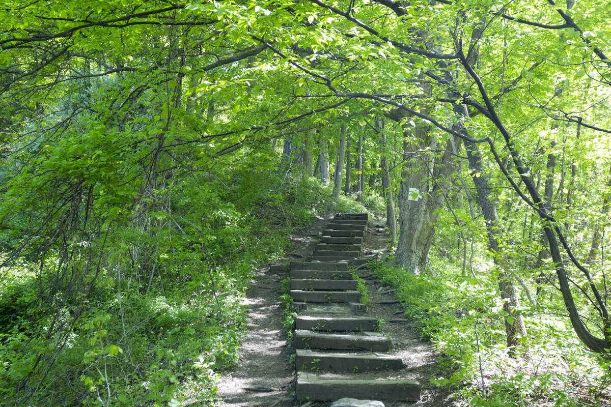
From the Dunnfield Creek parking area, look for a set of stone steps going up into the woods. That’s the start. The blazes (trail markers) are white rectangles with a red dot in the middle, painted on trees and rocks.
Step 2: The Warm-Up Climb
The trail climbs right away through the woods, with steps and rocks. It’s steep but steady. Go slower than you think you need to. Everyone who sprints this part is sitting on a rock five minutes later.
Step 3: The First Overlook (About 0.5 Mile)
Your first reward. A rocky ledge opens up with a view down to the Delaware River, little Arrow Island in the water, I-80 and Mount Minsi across the gap. Great spot for a water break and a photo. It’s also a perfect turnaround point if you only want a short hike.
Step 4: The Rock Scramble (About 0.75 Mile)
This is the real workout. The trail turns into a steep jumble of boulders. You’ll step up, reach up and sometimes pull yourself up with your hands. Look for the red dots painted on the rocks so you stay on the right line. Take it one rock at a time. It’s not dangerous if you’re careful, but it’s tiring.
Step 5: The Summit Viewpoint (About 1.2–1.3 Miles)
The trees open onto a wide, flat rock ledge, and there it is: the famous Delaware Water Gap view. You’ll see:
- The Delaware River winding through the gap like a ribbon
- Mount Minsi straight across in Pennsylvania
- Interstate 80 and its tiny cars far below, which show you just how high you’ve climbed
- Layers of ridges rolling into Pennsylvania on clear days
Find a spot, eat your snack and enjoy it. You’ve done the hard part. Just stay back from the edge, as the ledge drops off steeply.
Little secret: the viewpoint isn’t actually the very highest point. The true summit (about 1,527 feet) is a few hundred yards farther on, in the trees just off the Blue Dot Trail. There’s no view there, so most people don’t bother.
Step 6: Turn Onto the Blue Dot Trail
Keep walking past the viewpoint into the woods. After a short stretch (around 1.5–1.7 miles into your hike), you’ll see a double blue blaze and a sign. Turn sharply left onto the Blue Dot Trail. This is the turn people miss. Don’t keep going straight on the wide Mount Tammany Fire Road, which leads you away from your car.
Step 7: Down Through the Forest
The Blue Dot descends steadily through quiet woods. It’s still rocky in places, so watch your feet, but it’s much kinder than the Red Dot. Your knees will thank you.
Step 8: Dunnfield Creek and Back to the Car
Near the bottom (around 2.7–2.9 miles), the trail meets Dunnfield Creek and the green-blazed Dunnfield Creek Trail. Stay left. You’ll walk beside a pretty mountain stream with little cascades and a small waterfall. Then join the white-blazed Appalachian Trail for the last short stretch, cross the bridge and you’re back at the parking area.
Dip your hands in the cold creek. You’ve earned it.
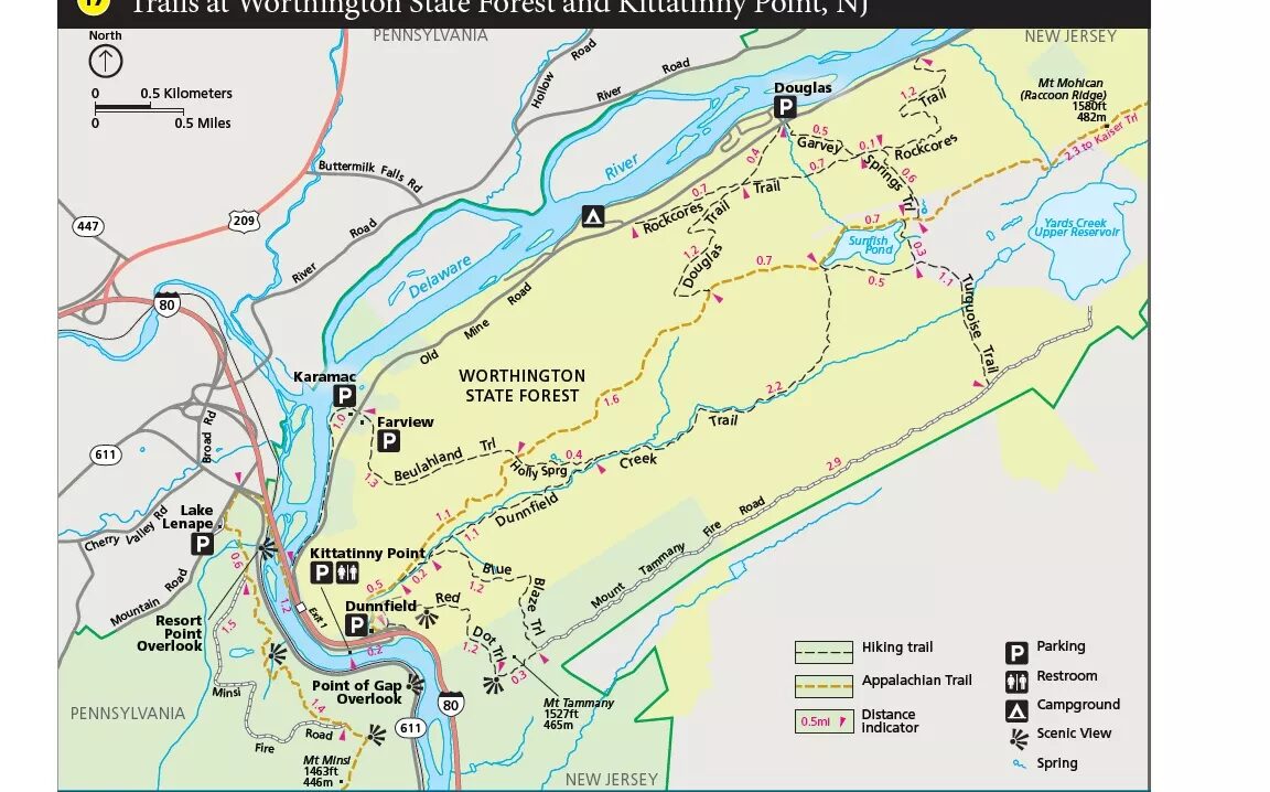
Mount Tammany Map and Trail Markers
| Trail | Blaze (marker) | What it does on the loop |
|---|---|---|
| Mount Tammany Trail (Red Dot) | Red dot on white | Steep climb to the summit view |
| Pahaquarry Trail (Blue Dot) | Blue (blue dot on white) | Easier way down |
| Dunnfield Creek Trail | Green | Short creekside stretch |
| Appalachian Trail | White | Last bit back to the parking lot |
Tip: cell signal comes and goes. Screenshot this map or download the route on AllTrails or Gaia before you leave home.
Mount Tammany Parking and Directions
Where to Park
Put “Dunnfield Creek Natural Area” into your GPS (address often listed as I-80, Columbia, NJ 07832), or use the coordinates 40.9720, -75.1258.
- Driving west on I-80: take the very last exit in New Jersey (Exit 1), just before the bridge to Pennsylvania. Look for the brown “Dunnfield Creek Natural Area” sign on the right.
- Driving east from Pennsylvania: cross the toll bridge into New Jersey and use your GPS to loop back to the Dunnfield / Kittatinny Point area. The turns change with construction, so live navigation is best.
The Two Lots (and the One-Way Trap)
There’s a small first lot and a bigger main lot right after it. The road between them is one-way, so if you drive past the first lot, you can’t turn back. You’d have to get back on I-80 and loop around. If you see an open space in the first lot, grab it.
When Is It Full?
On nice weekends from spring through fall, the lots are often full by 8 or 9 a.m. On peak fall-color Saturdays, even earlier. Weekdays are much easier.
Lot Full? Here’s Plan B
- Kittatinny Point Visitor Center lot: park here and walk about 10 minutes to the trailhead. It also has restrooms.
- Seasonal hiker shuttle: in busy months, a free shuttle has run between Kittatinny Point and the Delaware Water Gap Park and Ride in Pennsylvania. Check the latest schedule before relying on it.
- Never park on the I-80 shoulder or ramps. You will get a ticket or towed, and it’s dangerous.
Fees, Permits and Restrooms
- Cost: free. No parking fee and no hiking permit for day hikes.
- Restrooms: portable toilets at the main lot, and toilets at Kittatinny Point.
- Food and gas: the big travel plazas on I-80 about 5 minutes east of the trailhead are handy for coffee and a restroom stop before you hike.
Best Time to Hike Mount Tammany
| Season | What it’s like | Watch out for |
|---|---|---|
| Spring (April–May) | Fresh green leaves, cool temps, creek full of water | Mud and wet, slippery rocks |
| Summer (June–August) | Long days, lush forest | Heat, humidity, crowds, bugs; start early |
| Fall (September–November) | Gorgeous red, orange and gold views; peak mid-to-late October | Busiest time; lots full very early |
| Winter (December–March) | Quiet trail, clear views through bare trees | Ice and snow on the rocks; microspikes needed |
Right now (late October 2026): it’s prime leaf-peeping time at the Water Gap. The view is stunning, but so is the traffic. Go on a weekday, or be in the lot by 7–7:30 a.m. on weekends.
Sunrise and sunset: the summit faces west across the gap, so sunset is beautiful. If you stay for it, carry a headlamp and come down the Blue Dot slowly. Never try to go down the Red Dot in the dark.
How Long Does the Mount Tammany Hike Take?
| Part of the hike | Typical time |
|---|---|
| Parking lot to first overlook | 20–30 minutes |
| First overlook to summit view (the scramble) | 30–60 minutes |
| Hanging out at the top | 20–40 minutes |
| Blue Dot down to the creek and car | 60–90 minutes |
| Total | About 2.5–4 hours |
Fast, fit hikers can do it in about 2 hours. Families and first-timers should plan for closer to 4.
What to Bring
- Shoes with real grip. Hiking shoes or trail runners. Not sandals, not smooth sneakers.
- At least 1–2 liters of water per person (more in summer). There’s no drinking water on the trail.
- A snack for the summit. It tastes better up there. Promise.
- A light layer. It’s windier at the top.
- A charged phone with an offline map.
- Trekking poles for the way down (pack them away on the Red Dot scramble, as you’ll want your hands free).
- A rain jacket if showers are possible.
- Microspikes in winter.
Staying Safe on Mount Tammany
Because it’s so popular, Mount Tammany sees a lot of rescues, usually twisted ankles, slips on the way down and people who ran out of water or daylight. A little planning avoids almost all of it.
- Go up Red, down Blue. Don’t descend the Red Dot scramble.
- Skip the Red Dot when it’s wet or icy. Use the Blue Dot both ways instead.
- Stay back from the summit edge, especially with kids and when taking photos.
- Watch for snakes on sunny rocks in summer. Timber rattlesnakes and copperheads live on the Kittatinny Ridge. Give them space, and they’ll leave you alone.
- Check for ticks after your hike, from spring through fall.
- Black bears live here too. Keep food packed away and never feed them.
- Start early enough to finish in daylight.
Kids and Dogs
Kids: energetic kids around 8 and up who’ve hiked before usually love the rock scramble; they treat it like a jungle gym. For little ones, try the first overlook or the flat walk to Dunnfield Creek Falls instead.
Dogs: leashed dogs are commonly seen on the trail, but the Red Dot boulders are tough for many dogs, especially small or older ones. If you bring your dog, consider using the Blue Dot both ways, and bring water for them.
Common Mistakes First-Timers Make
- Thinking “3 miles = easy.” It’s a short hike with a big climb.
- Showing up at 10 a.m. on a Saturday and finding nowhere to park.
- Driving past the first lot on the one-way road.
- Missing the sharp left onto the Blue Dot and walking down the fire road.
- Going down the Red Dot on tired legs.
- Bringing one small water bottle on a hot day.
More to Do Nearby
- Dunnfield Creek Falls: an easy, shady walk from the same parking lot to a lovely little waterfall.
- Sunfish Pond: a beautiful glacial lake on the Appalachian Trail, about 4 miles from the trailhead. Combine it with Tammany for a big day.
- Mount Minsi (Pennsylvania): Tammany’s twin across the river, with views back at the mountain you just climbed.
- Delaware Water Gap village (PA): a small town just over the bridge with cafes and a bakery for a post-hike treat.
- Kittatinny Point: visitor area by the river, good for a picnic and river views.
Love a big view at the end of a hard climb? You might also enjoy Indian Head in the Adirondacks or the Alum Cave Trail in the Smoky Mountains.
Mount Tammany Hike FAQs
How long is the Mount Tammany hike?
The Red Dot–Blue Dot loop is about 3–3.6 miles. Plan on 3.5 miles and 2.5–4 hours.
How hard is the Mount Tammany hike?
It’s difficult. You climb about 1,200 feet in 1.2 miles on steep, rocky trail with some hand scrambling.
How long does it take to reach the summit?
Most people reach the summit viewpoint in 50–90 minutes on the Red Dot Trail.
Should I go up Red Dot or Blue Dot?
Go up the Red Dot and come down the Blue Dot. Red has the views and is easier to climb up than down.
Where do you park for Mount Tammany?
At the Dunnfield Creek Natural Area lots off I-80’s last New Jersey exit (Exit 1, westbound). Overflow parking is at Kittatinny Point Visitor Center.
Is there a fee or permit?
No. Parking and hiking are free, and day hikers don’t need a permit.
What can you see from the top?
The Delaware River winding through the Delaware Water Gap, Mount Minsi in Pennsylvania, I-80 far below and ridges stretching into the distance.
How high is Mount Tammany?
About 1,527 feet above sea level. The summit view ledge is just a little lower.
Is Mount Tammany good for beginners?
For fit beginners on a dry day, yes. Otherwise, try the first overlook (about 1 mile round trip) or the easy walk to Dunnfield Creek Falls.
Are dogs allowed on Mount Tammany?
Leashed dogs are commonly seen, but the rocky Red Dot scramble is hard for many dogs. The Blue Dot is friendlier for pups.
When is the best time to hike Mount Tammany?
Spring and fall. Peak fall color is usually mid-to-late October. Go on a weekday or very early on weekends.
Can you hike Mount Tammany in winter?
Yes, with microspikes and experience. Ice on the Red Dot rocks is dangerous, so many winter hikers use the Blue Dot both ways.
Is the Mount Tammany Hike Worth It?
Every bit of it. In about three hours, you get a real mountain climb, a rock scramble that makes you feel like a kid again, one of the best views in New Jersey, and a peaceful walk home beside a mountain creek. Not bad for a hike that starts next to an interstate.
Get there early, wear good shoes, go up Red and down Blue, and take your time at the top. The Mount Tammany hike will probably become one you come back to again and again.
Official Information
- NPS: Mt. Tammany Trail (Red Dot)
- NPS: Delaware Water Gap current conditions and alerts
- Delaware Water Gap NRA information: 570-426-2452
1 thought on “Mount Tammany Hike: Red Dot & Blue Dot Loop, Distance, Difficulty, Parking & Summit Guide (2026)”