
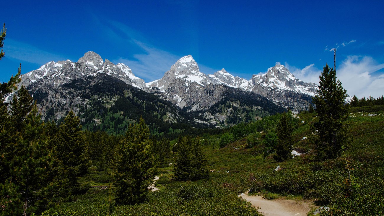
Some Grand Teton hikes make you work for hours before the mountains show up. The Taggart Lake Trail doesn’t. Within a few minutes of leaving the car, you’re walking through sagebrush with the Grand Teton straight ahead, and it only gets better from there.
The hike packs a lot into a short distance. You cross open sagebrush flats, follow Taggart Creek, climb a glacial moraine through aspens and young lodgepole pines, and finish at a clear mountain lake sitting right below Avalanche Canyon. Under normal conditions it’s about 3 miles round trip and rated easy by the National Park Service.
There’s one big catch for 2026: trail construction has closed the usual shorter route, so the hike is longer and steeper this year. This guide covers both the normal route and the current detour, plus Bradley Lake, parking, the best time to go, wildlife, what to bring and how Taggart fits into a Grand Teton trip.
Taggart Lake Trail at a Glance
| Trail Detail | What to Know |
|---|---|
| Location | Grand Teton National Park, Wyoming, near Moose |
| Trailhead | Taggart Lake Trailhead, Teton Park Road |
| Normal distance | About 3 miles round trip |
| Normal elevation gain | About 350–360 feet |
| Normal time | 1–2 hours |
| Normal difficulty | Easy |
| 2026 route | Southern route only, about 4.25 miles round trip, longer and steeper |
| Trail type | Out and back (loops available in normal years) |
| Reservations or permit | Not needed for a day hike |
| Dogs | Not allowed |
| Season | Year-round (snowshoe or ski in winter) |
| Best for | Teton views, a short lake hike, families, photographers |
2026 construction alert: the northern section of the Taggart Lake Trail, between the first junction and the Bradley Lake trail, is closed for reconstruction, with the closure scheduled to run through November 15, 2026. The trailhead and parking lot are open, and you can still reach the lake on the longer southern route. Follow posted signs and check the park’s current conditions page before you go.
In This Guide
- 2026 construction update
- How long is the Taggart Lake Trail?
- Is it hard?
- What the hike is like
- Bradley Lake and Beaver Creek options
- Parking and facilities
- Best time to hike
- Wildlife and bear safety
- What to bring
- FAQs
Is the Taggart Lake Trail Worth It?
Yes. The Taggart Lake Trail is one of the best short hikes in Grand Teton National Park, giving you close-up views of the Grand Teton, Middle Teton and Avalanche Canyon, plus a glacial lake, for far less effort than the park’s big canyon hikes.
The scenery-to-effort ratio is hard to beat. Plenty of mountain trails make you climb for hours before the landscape opens up. Here, the Tetons are in front of you almost from the first step, and you pass through several different landscapes in a single short outing.
It works for a lot of different people: first-time visitors, families with kids who’ve hiked before, photographers, travelers with only a morning to spare, and experienced hikers who want an easier day between big ones. It’s no surprise the park calls this trailhead one of its busiest year-round spots.
Where Is the Taggart Lake Trail?
The Taggart Lake Trailhead is in the southern part of Grand Teton National Park, on Teton Park Road about 3.5 miles northwest of Moose Junction and a couple of miles past the Moose Entrance Station. From the town of Jackson, plan on roughly 25–35 minutes of driving, more with 2026 construction delays near Moose.
That location makes Taggart easy to pair with other stops. Jenny Lake is about 10 minutes north, and Mormon Row, Antelope Flats and the Snake River Overlook are all a short drive away. For the full picture, see our Grand Teton National Park itinerary.
Taggart Lake Trail 2026 Construction Update
Is the Taggart Lake Trail open in 2026? Yes, but only partly. The shorter northern section is closed for reconstruction through November 15, 2026, so hikers reach Taggart Lake on the southern route, which the park lists at about 4.25 miles round trip and describes as longer and steeper.
This is part of a multi-year project to renew the trail and trailhead, which have been worn down by heavy use and erosion. Crews are widening and smoothing the trail and fixing badly eroded sections. When the work is finished, the park plans a redesigned trailhead with better accessibility, restrooms, a water bottle filling station and a larger parking lot.
In practice, the southern route follows what is normally the Beaver Creek side of the loop, out and back. Some hikers’ GPS tracks come in closer to 4.8 miles depending on where they wander along the shore. The nearby Cottonwood Creek Picnic Area is also closed for construction.
Two rules matter most this year. First, don’t trust an old map, a GPS app or last year’s blog post over the signs at the trailhead. Second, never walk into a closed section, even if your app says it’s the quicker way. Check the park’s alerts and construction updates the day before you go, because plans can change.
How Long Is the Taggart Lake Trail?
In a normal year, the Taggart Lake Trail is about 3 miles round trip with roughly 360 feet of elevation gain and takes 1–2 hours. In 2026, the open southern route is about 4.25 miles round trip, with more climbing.
| Route | Distance | Climbing | Time | Difficulty |
|---|---|---|---|---|
| Taggart Lake (normal route) | About 3 mi round trip | About 350–360 ft | 1–2 hours | Easy |
| Taggart Lake (2026 southern route) | About 4.25 mi round trip | More, with steeper sections | 2–3 hours | Easy to moderate |
| Taggart Lake–Beaver Creek Loop (normal) | About 3.8–3.9 mi | About 500–620 ft | 2–3 hours | Moderate |
| Taggart Lake–Bradley Lake Loop (normal) | About 5.9 mi | About 800 ft | About 3 hours | Moderate |
Leave extra time for the lake itself. Most people end up sitting on the shore longer than they planned, and that’s half the point.
Is the Taggart Lake Trail Hard?
No. In normal conditions the Taggart Lake Trail is an easy hike, with gentle climbing, rocks and a few steps. The 2026 detour is longer and steeper, so it feels closer to easy-to-moderate this year.
“Easy” doesn’t mean flat. The trail climbs up and over a glacial moraine, the ground is uneven in places, and you’re hiking at around 6,600–7,000 feet. If you’ve just arrived from sea level, you’ll notice the thinner air on the climbs. Weather matters too. The same trail that feels effortless on a cool, dry morning is a different story in midday heat, a thunderstorm, or on ice in late fall.
Is Taggart Lake Good for Beginners?
Yes. It’s one of the most approachable scenic hikes in the park and a great first hike in Grand Teton. Wear proper shoes, bring water, take your time on the climbs and plan on the longer distance if you’re hiking in 2026.
Can Kids Hike Taggart Lake?
In a normal year, Taggart is one of the most family-friendly lake hikes in the park, and plenty of kids who already have a few hikes under their belt handle it well. There are hills, roots and rocks, though, so it’s not a stroller trail. For 2026, remember that the detour adds more than a mile and some steeper climbing, which can be a lot for younger children. The easy String Lake trail or the Lakeshore Trail at Colter Bay are good alternatives this year. Our guide to Grand Teton National Park with kids has more family-friendly hikes.
Is Taggart Lake Wheelchair Accessible?
Not at the moment. The trail has rocks, steps and grades that aren’t suitable for wheelchairs or strollers. Better accessibility is one of the goals of the current renewal project, so this may change once the work is done.
What Is the Taggart Lake Trail Like?
Part of the fun is how fast the scenery changes. You’re not just walking through forest until a lake appears.
The Trailhead and Sagebrush Flats
The trail starts level, crossing open sagebrush with the Grand Teton rising in the distance. Before you set off, read the trailhead signs. That’s always smart, but it’s essential in 2026, when temporary directions override older maps. Morning and evening light on this open stretch is lovely for photos.
Taggart Creek and the Old Burn
The trail soon follows Taggart Creek and crosses it on sturdy footbridges. About a mile in, you walk through an area burned in the 1985 Beaver Creek Fire. Four decades later, it’s a good lesson in how forests recover. Young lodgepole pines and aspens have filled in, and wildflowers bloom here in early summer. Look for huckleberries along the trail in late summer.
Up and Over the Moraine
Taggart Lake sits behind a moraine, a long ridge of rock and debris left behind when the glacier that carved Avalanche Canyon melted back. The climb up this ridge is where most of the elevation gain happens. Once you’re on top, the trail flattens out and the peaks open up in front of you. In fall, the aspens along this stretch turn bright yellow.
Reaching Taggart Lake
Then the trees part and there’s the lake. Taggart Lake covers about 305 acres and reaches roughly 80 feet deep. It sits right at the mouth of Avalanche Canyon, a steep, trailless valley between Nez Perce Peak and Mount Wister. Look north and you’ll see the Grand Teton, Middle Teton, Mount Owen, Teewinot Mountain and the notch of Garnet Canyon. On a calm morning, the reflections are superb.
Find a spot on the rocky shore, have a snack and take your time. There’s no rush to turn around. If you look closely up Avalanche Canyon, you may even spot a waterfall tumbling down its walls.
A bit of history: the lake is named after W. Rush Taggart, assistant geologist on the 1872 Hayden Expedition. Neighboring Bradley Lake is named for his boss, chief geologist Frank Bradley.
Taggart Lake vs. Bradley Lake (and the Beaver Creek Loop)
If Taggart feels too short, Bradley Lake is the natural next step. It sits just north of Taggart at the mouth of Garnet Canyon, fed by meltwater from high up near the Middle Teton. It’s a little smaller, often quieter, and gives you a different angle on the peaks.
| Feature | Taggart Lake | Taggart + Bradley Lakes |
|---|---|---|
| Normal distance | About 3 miles | About 5.9 miles |
| Normal climbing | About 350–360 ft | About 800 ft |
| Normal time | 1–2 hours | About 3 hours |
| Difficulty | Easy | Moderate |
| Lakes | 1 | 2 |
| Best for | A short scenic hike | A half-day outing |
In a normal year, the Taggart Lake–Bradley Lake loop climbs over the moraine between the two lakes and returns on the Taggart Lake Trail. The Taggart Lake–Beaver Creek Loop is the other classic option, adding some extra climbing on the way back along Beaver Creek. It’s a nice middle ground when you want more than the out-and-back but less than Bradley.
In 2026, neither loop can be completed as usual, because the closed northern section is part of both. Some trail beyond the lake may still be open, but check the signs at the trailhead and at each junction before planning a longer day, and don’t try to link routes through a closed section.
Taggart Lake Trail Parking and Facilities
Parking is the biggest practical headache here. The lot has around 59 spaces, including a few for larger vehicles, and it fills quickly in summer because this is such a popular short hike. When it’s full, parking is allowed only along the designated stretches on the west side of Teton Park Road. Pull fully off the pavement and never create your own spot.
The trailhead has a vault toilet, a bike rack, a trailhead sign and a brochure box. There’s no drinking water, so fill up before you arrive. Grand Teton charges an entrance fee, and in 2026 the park moved to cashless payment for entrance fees, so bring a card or have a pass ready.
What Time Should You Arrive?
In summer, arrive before 8–9 a.m. for the best chance at a parking spot. Late afternoon can also work, but check sunset time and allow for the longer 2026 route.
An early start pays off in other ways too: cooler temperatures, softer light on the peaks, calmer water for reflections, quieter trails and a better chance of seeing wildlife. It also leaves the rest of your day free for somewhere like Jenny Lake.
Best Time to Hike the Taggart Lake Trail
Late June through September is the best time to hike Taggart Lake, and mid-to-late September is the sweet spot, with golden aspens, cooler air and thinner crowds. Early morning is the best time of day.
| Season | What to Expect |
|---|---|
| Spring (April–early June) | Snow, ice, mud and high runoff are common. Conditions change week to week. |
| Summer (late June–August) | Easiest hiking, long days and wildflowers. Busiest parking and afternoon thunderstorms. |
| September | Cool mornings, fewer people and aspens starting to turn. Weather gets less predictable later in the month. |
| October | Frost, cold wind and possible early snow. Beautiful when it’s clear, but carry layers. |
| Winter | Snowshoeing and cross-country skiing. Teton Park Road closes to cars north of this area in winter, so the trailhead becomes a popular winter starting point. |
Taggart Lake in September and Fall
If you can pick one time, pick September. The summer rush fades, the air is crisp and the aspens on the moraine turn gold against the dark peaks. Wildlife is also more active as animals prepare for winter. The trade-off is weather. A warm afternoon doesn’t promise a warm morning, and the high peaks can get fresh snow while the lake stays mild. Bring layers and check the forecast right before you leave. For timing and more autumn spots, see our guides to Grand Teton in September and Grand Teton fall colors.
For timing the rest of your trip, see our guides to the best time to visit Grand Teton National Park and Grand Teton weather by month.
Taggart Lake in Winter
Taggart Lake doesn’t disappear from the map when snow falls. The park lists it as accessible year-round on snowshoes or cross-country skis. Winter travel is a different game, though. You need proper gear, shorter plans for short days, and an understanding of avalanche terrain if you go beyond the lake. Check whether any 2026 construction closures are still in place before a late-fall visit.
Wildlife and Bear Safety on the Taggart Lake Trail
The Taggart Lake area is active wildlife habitat. Moose, elk, mule deer and black and grizzly bears all use this part of the park, and marmots, squirrels and birds are common along the trail. Seeing an animal can be the highlight of your hike, as long as you keep your distance. Grand Teton requires you to stay at least 100 yards from bears and wolves and 25 yards from all other wildlife. Never walk closer for a photo.
Do You Need Bear Spray at Taggart Lake?
Yes. Carry bear spray on the Taggart Lake Trail. Both black bears and grizzlies live in the area, and the park warns that bears can be active anywhere, at any time.
Keep the spray on your hip or chest strap, not buried in your pack, and learn how to use it before you set off. Hike in a group when you can, talk or make noise where the trail bends through thick brush, and be extra alert in late summer when bears come for the berries. Our Grand Teton wildlife guide covers where and when to see each animal safely.
Rules and Practical Questions
Can You Swim in Taggart Lake?
Some hikers do take a quick dip on hot days, and kids often love wading at the edge. Just know that the water is fed by snowmelt and stays very cold even in August. There are no lifeguards, cold water can shock your body quickly, and mountain weather can change fast. For most people, the lake is better as a place to rest, snack and take photos.
Are Dogs Allowed on the Taggart Lake Trail?
No. Pets aren’t allowed on Grand Teton’s hiking trails, including Taggart Lake. In the park, dogs are generally limited to roads, parking areas and campgrounds on a leash, so plan something else for your dog.
Do You Need a Permit for Taggart Lake?
No permit or reservation is needed for a day hike. You just need to pay the park entrance fee or show a valid pass. Overnight backcountry camping anywhere in Grand Teton requires a permit.
What to Bring on the Taggart Lake Hike
Even a short mountain hike deserves a little preparation:
- Water (there’s none at the trailhead)
- Comfortable hiking shoes with good grip
- Layers and a rain jacket
- Sunscreen, sunglasses and a hat
- Bear spray within easy reach
- Snacks for the lakeshore
- A small first-aid kit
- An offline map (with the 2026 detour in mind)
- Camera or phone, plus binoculars for wildlife
Don’t underestimate the sun just because the air feels cool. At this elevation, and on the open sagebrush stretches, you can burn surprisingly fast.
Gear Worth Considering
A few items make the hike more comfortable: a bear spray holster, a light daypack, a reusable water bottle or small hydration pack, microspikes for icy spring and fall mornings, and snowshoes or skis if you’re coming in winter. If you’re flying into Jackson, you can rent bear spray in town rather than buying a can you can’t take home on the plane.
Taggart Lake Photography Tips
You don’t need a complicated plan. The landscape does most of the work. Go early for calm water and reflections, and use a wide-angle lens to fit the lake and peaks in one frame. The rocky northeast shore is a favorite spot for looking up Avalanche Canyon. In fall, use the yellow aspens as foreground to add depth. For wildlife, bring a telephoto lens instead of walking closer.
Taggart Lake vs. Other Easy Grand Teton Hikes
| Hike | Choose It If You Want |
|---|---|
| Taggart Lake | A short hike to a quiet glacial lake with big Teton views, with no boat needed |
| Hidden Falls (Jenny Lake) | A waterfall and a boat ride, with bigger crowds |
| String Lake | Easy, mostly flat lakeshore walking, and shallow water for wading |
| Lakeshore Trail (Colter Bay) | A flat, easy loop with Jackson Lake views, a good 2026 alternative |
| Cascade Canyon | A full-day hike deep into the mountains |
If you have more time and energy, the Cascade Canyon Trail is the next step up. For every option in the park, see our list of the best hikes in Grand Teton National Park.
A Half-Day Taggart Lake Plan
Start at the Taggart Lake Trailhead by 8 a.m. and hike to the lake on the currently open route. Give yourself time on the shore before heading back. Then drive 10 minutes north to Jenny Lake, or head east to Mormon Row and Antelope Flats for wide Teton views and a chance to see bison or pronghorn from the car. Finish at Schwabacher Landing or the Snake River Overlook in the evening light. It’s a balanced day without cramming in too many hikes.
Where to Stay Near Taggart Lake
Taggart Lake is in the south end of the park, so Jackson is the easiest base, with the widest range of hotels, restaurants and gear shops about half an hour away. Inside the park, Jenny Lake Lodge and Jenny Lake Campground are about 10 minutes north, and the Moose area has a few small lodging options. Staying close makes it much easier to grab an early parking spot.
Common Taggart Lake Mistakes to Avoid
- Arriving late. A short hike doesn’t mean easy parking. The lot fills fast.
- Following an old route in 2026. The traditional northern route is closed. Follow the signs, not your app.
- Planning a loop this year. Both classic loops use the closed section.
- Skipping bear spray. This is bear country, even on a busy trail.
- Bringing too little water. There’s no water at the trailhead.
- Treating “easy” as risk-free. Weather, altitude, ice and wildlife still matter.
Related Guides
Keep planning with these related guides:
- Best Things to Do in Grand Teton National Park
- Where to Stay Near Grand Teton National Park
- Grand Teton in October
- Yellowstone and Grand Teton Road Trip
Taggart Lake Trail FAQs
How long is the Taggart Lake Trail?
Normally about 3 miles round trip with roughly 360 feet of elevation gain. In 2026, the open southern route is about 4.25 miles round trip because the shorter northern section is closed for construction.
Is the Taggart Lake Trail open in 2026?
Yes, partly. The trailhead and parking lot are open and the lake can be reached on the southern route. The northern section is closed for reconstruction through November 15, 2026.
How difficult is the Taggart Lake Trail?
The normal route is rated easy by the park. The 2026 southern route is longer and steeper, so it feels closer to easy-to-moderate.
How long does it take to hike to Taggart Lake?
About 1–2 hours on the normal route, or 2–3 hours on the 2026 detour. Add time for relaxing and taking photos at the lake.
Is Taggart Lake good for beginners and kids?
Yes, in a normal year it’s one of the park’s most approachable scenic hikes. In 2026, the longer route may be a stretch for young children.
Which is better, Taggart Lake or Bradley Lake?
Taggart is the easier, shorter hike with a classic view up Avalanche Canyon. Bradley is quieter and usually combined with Taggart on a 5.9-mile loop in normal years.
Do you need a reservation for Taggart Lake?
No reservation or permit is needed for a day hike. You only need to pay the park entrance fee or have a valid pass.
Is there parking at the Taggart Lake Trailhead?
Yes, around 59 spaces plus designated roadside parking. It fills quickly in summer, so arrive early.
Are dogs allowed on the Taggart Lake Trail?
No. Pets aren’t allowed on Grand Teton hiking trails.
Are there bears near Taggart Lake?
Yes. Black bears and grizzly bears both live in the area. Carry bear spray, stay alert and follow the park’s bear-safety guidance.
Can you hike to Taggart Lake in winter?
Yes. The park lists Taggart Lake as accessible year-round on snowshoes or cross-country skis, with proper winter gear and preparation.
Final Thoughts on Hiking the Taggart Lake Trail
Grand Teton has bigger lakes, longer trails and much harder climbs. Taggart doesn’t try to compete with them. Its appeal is simplicity. You walk away from the road, cross the sagebrush, climb through the aspens as the Tetons get bigger with every step, and end up at a quiet glacial lake right under the mountains.
Just remember that 2026 isn’t a normal year here. Check the latest conditions, follow the detour signs and plan for a slightly longer walk. With that small bit of preparation, Taggart Lake is still one of the easiest ways to feel the scale of the Tetons on foot. For more ideas, browse all of our travel guides.