

Drive across the Texas Panhandle and the land is as flat as a tabletop. Then, about half an hour south of Amarillo, the ground suddenly falls away into a canyon of red, orange, yellow and white rock 800 feet deep. Down on the canyon floor, a dusty trail winds for almost three miles to a 300-foot tower of stone standing all by itself against the sky. That’s the Lighthouse, and the trail to it is the most famous hike in Texas’ “Grand Canyon.”
The Lighthouse Trail in Palo Duro Canyon is mostly gentle, and families, trail runners, mountain bikers and first-time hikers all do it. But don’t let “moderate” fool you. There’s almost no shade, the canyon floor is often 5–10°F hotter than the rim, and the park says this trail sees many of its heat emergencies. The last stretch up to the base of the Lighthouse is also a short, steep scramble on loose rock.
This guide covers it all: distance and map, a section-by-section walk-through, the rock formation and how it formed, the final scramble, summer heat closures and water rules, fees and reservations, parking, dogs, kids, photography, where to stay, and other trails in the park.
Cover photo: the Lighthouse, Palo Duro Canyon State Park. Photo: Sefor4 / Wikimedia Commons, CC BY-SA 3.0
Heads-up for December 2026: The park closes beyond the Old West Stables from 10 p.m. on December 1 to 7:30 a.m. on December 14 for a permitted wildlife-management hunt. Only the CCC Trail is open during that time, so the Lighthouse Trail is closed. The backcountry stays closed until December 18. Check the park’s alerts page before any visit.
Lighthouse Trail: The Short Answer
The Lighthouse Trail is an out-and-back hike of about 5.7–5.9 miles round trip (Texas Parks & Wildlife lists 2.8 miles one way) in Palo Duro Canyon State Park near Canyon, Texas. It follows the canyon floor with only about 450–500 feet of gentle climbing, then finishes with a short, steep scramble to the base of the 300-foot Lighthouse rock formation. Plan 2.5–4 hours. Hike in the morning, carry about 1 liter of water per person per mile, and expect midday closures on heat-advisory days.
Lighthouse Trail: Quick Facts
| Detail | Information |
|---|---|
| Location | Palo Duro Canyon State Park, near Canyon and Amarillo, Texas |
| Trailhead | Lighthouse Trailhead on Park Road 5, on the canyon floor |
| Distance | About 2.8–2.9 miles one way; 5.7–5.9 miles round trip |
| Elevation gain | About 450–500 feet, plus a short, steep climb at the end |
| Difficulty | Moderate trail; difficult final scramble |
| Time needed | 2.5–4 hours, longer with breaks and photos |
| Shade | Very little; a few covered benches along the way |
| Lighthouse height | About 300–310 feet |
| Trail uses | Hiking, mountain biking and horses (final climb is foot traffic only) |
| Entrance fee | $8 per person 13 and older; kids 12 and under free |
| Best months | March–May and late September–November |
| Heat rule | Closes 11 a.m.–5 p.m. on National Weather Service heat-advisory days |
| Dogs | Allowed on a leash; dangerous for dogs in heat |
Where Is the Lighthouse Trail?
The trail is inside Palo Duro Canyon State Park, about 12 miles east of the town of Canyon and roughly 25–30 miles south of Amarillo. Palo Duro is the second-largest canyon in the United States: about 120 miles long, up to 20 miles wide and up to 800 feet deep, carved by the Prairie Dog Town Fork of the Red River.
Getting there: From Amarillo, take I-27 south to Canyon, then follow TX-217 east about 10 miles to the park entrance (11450 Park Road 5, Canyon, TX 79015). Pay or show your pass at the entrance, then drive down the steep, winding road into the canyon. Follow Park Road 5 along the canyon floor across the low-water crossings to the Lighthouse Trailhead parking area, roughly halfway along the park road. From Amarillo, plan on 35–45 minutes.
Flash flood warning: Park Road 5 crosses the river at several low-water crossings. After heavy rain, the park may close the road and trails. Never drive into moving water.
Lighthouse Trail Map and Route
Two paths leave the parking area and join after a short distance; both are signed for the Lighthouse. From there it’s a simple out-and-back. Several other trails cross or branch off along the way, including the Givens, Spicer & Lowry (GSL) Trail, so keep following the Lighthouse signs.
| Section | Approx. miles (one way) | What it’s like |
|---|---|---|
| Trailhead to first shade shelter | 0–1.5 | Wide, sandy path across open canyon floor with views of Capitol Peak |
| Middle section | 1.5–2.4 | Gentle ups and downs past red cliffs and small hoodoos; first views of the Lighthouse |
| End of the main trail | 2.4–2.8 | Trail narrows as it heads up a side canyon toward the Lighthouse |
| Final scramble (optional) | Last ~0.2 | Short, steep climb on loose dirt and rock to the platform at the Lighthouse’s base |
Get the official trail map from the Texas Parks & Wildlife Palo Duro Canyon page or the TPWD app before you go, and screenshot it. Cell signal on the canyon floor is unreliable.

Hiking the Lighthouse Trail: Section by Section
1. The Open Canyon Floor
The first mile and a half is easy walking on a wide dirt and sand path through juniper, mesquite, yucca and prickly pear. To your left, the layered cliffs of Capitol Peak and Capitol Mesa rise above the trail, banded in red, purple and white. Across the valley, Fortress Cliff stretches along the far rim.
It feels easy, and that’s the trap. You’re fully in the sun, and the heat builds fast on the canyon floor. Drink before you’re thirsty.
2. Shade Shelters and the Middle Miles
Along the way you’ll pass a few covered benches. They’re some of the only shade on the trail, so use them. The path rolls gently up and down over small washes, with stone steps in a few spots. Watch for little hoodoos (mushroom-shaped rocks) beside the trail, collared lizards sunning on boulders, and roadrunners darting across the path.
Somewhere past the halfway point, the Lighthouse appears ahead: a slim, flat-topped tower standing apart from the canyon wall. The closer you get, the bigger it looks.
3. The End of the Main Trail
Near the end, the trail narrows and curves into a side canyon below the Lighthouse. Bikes and horses stop here. There’s a final bench area where many hikers rest, take photos and turn around. You get a great view of the Lighthouse and its neighbor, Castle Rock, without any scrambling.
4. The Final Scramble to the Lighthouse
If you want to stand at the foot of the Lighthouse, the last couple of hundred yards climb steeply up a rocky, eroded slope. The dirt is loose and slippery, and in places you’ll use your hands for balance. At the top, a flat platform sits between the Lighthouse and Castle Rock, with big views back down the canyon and over the other side into Sunday Canyon.
- Wear shoes with good grip. Sandals and smooth sneakers are a bad idea here.
- Go up slowly, and come down even slower. Coming down is when most slips happen.
- Skip it in rain, strong wind or heat, and if you’re tired or uneasy with heights.
- Don’t climb the Lighthouse itself. The soft rock crumbles and breaks easily.
The scramble is optional. You’ll have a great hike even if you stop at the bottom.
The Lighthouse Rock Formation: What Makes It Special
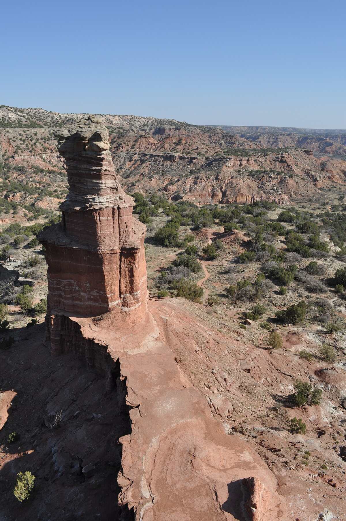
The Lighthouse is a hoodoo, a tall pillar of rock left standing after the land around it wore away. It rises roughly 300–310 feet from its base and is the symbol of Palo Duro Canyon State Park.
How it formed: The tower is made of layers of soft red and white mudstone and shale (the Tecovas Formation), topped by a harder cap of sandstone from the Trujillo Formation. Both date back more than 200 million years, to the Triassic period. The hard cap acts like an umbrella. Rain, wind and the river wore away the softer rock all around it, but the capped column survived, slowly narrowing into a tower.
It won’t last forever. The same erosion that made the Lighthouse is still wearing it down, which is one more reason to stay off the rock and on the trail.
How Hard Is the Lighthouse Trail?
The park rates the Lighthouse Trail moderate. On a cool, cloudy day, most people find the main trail fairly easy: it’s wide, well used and only gains a few hundred feet. What makes it harder:
- Heat and sun: the biggest danger by far. There’s very little shade.
- Distance: nearly 6 miles round trip is a lot for kids and new hikers, especially on the hot walk back.
- Sand: soft, sandy patches make walking slower and more tiring.
- The final scramble: short, steep and loose.
| Hiker | Typical round-trip time |
|---|---|
| Fit hikers, cool morning | 2–2.5 hours |
| Average pace with breaks and photos | 3–4 hours |
| Families with kids or slower walkers | 4–5 hours |
| Trail runners | About 1–1.5 hours |
New to hiking? Read our hiking for beginners guide first, and pick a cool morning for your first try.
Summer Heat: Rules You Need to Know
This is the most important section in this guide. Palo Duro gets very hot in summer, and the canyon floor is often 5–10°F hotter than the rim. The park has seen rescues and deaths from heat on its trails, and the Lighthouse Trail is the busiest of them all.
- Heat-advisory closures: When the National Weather Service issues a heat advisory for the canyon, the park closes the Lighthouse, Givens, Spicer & Lowry, Rock Garden and Upper and Lower Comanche trails from 11 a.m. to 5 p.m. Rangers say advisories usually come with temperatures around 105°F or higher.
- Water rule: The park recommends about 1 liter (about a quart) of water per person, per mile. For the full Lighthouse hike, that’s roughly 6 liters, or about 1.5 gallons, per person.
- No water on the trail. Fill up before you leave the car.
- Turn around at half your water. The walk back is usually hotter than the walk out.
Know the warning signs: Heavy sweating, dizziness, headache, nausea, cramps or weakness can mean heat exhaustion. Stop, get in shade, drink and cool down. Confusion, hot dry skin, fainting or slurred speech can mean heat stroke, which is a medical emergency. Call 911 and cool the person right away.
Best Time to Hike the Lighthouse Trail
| Season | What to expect |
|---|---|
| Spring (March–May) | Pleasant temperatures and green canyon floor. Windy days and spring storms are common. Busy around spring break. |
| Summer (June–August) | Very hot. Hike at sunrise only, and expect midday closures on heat-advisory days. Summer storms can cause flash floods. |
| Fall (late September–November) | Our favorite. Cooler days, golden cottonwoods along the river, and great light on the cliffs. |
| Winter (December–February) | Cool and quiet, sometimes freezing. Snow or ice now and then. Watch for the December hunt closures. |
Best time of day: Start as early as the park allows. Mornings are cooler, the trailhead lot has space, and low sun lights up the red rock. Weekday mornings are the quietest of all.
Fees, Reservations, Hours and Parking
- Entrance fee: $8 per person per day for ages 13 and up; kids 12 and under are free. A Texas State Parks Pass covers entry for the pass holder and their guests.
- Reservations: The park often fills on weekends, holidays and spring break. Buy a day pass online in advance to guarantee entry.
- Hours: Open daily. Check the park website for current gate and office hours before you go.
- Parking: Free at the Lighthouse Trailhead once you’re inside the park. It fills by mid-morning on busy days, so arrive early.
- Restrooms: Use the restrooms along Park Road 5 before you start. There are none on the trail.
What to Wear and Pack
- Lots of water (about 1 liter per person per mile) plus electrolyte drinks or salty snacks
- Wide-brimmed hat, sunglasses and sunscreen
- Light, loose, light-colored clothing with sun protection
- Trail shoes or hiking boots with good grip for sand and the scramble
- Low gaiters to keep sand and pebbles out of your shoes (see our trail running gaiters guide)
- Snacks, a small first-aid kit and a whistle
- Offline map and a charged phone (a small power bank helps)
- Trekking poles are handy on the scramble descent (see budget trekking poles)
Is the Lighthouse Trail Good for Kids?
Yes, in cool weather and with a plan. The main trail is wide and gentle, and kids love spotting lizards and climbing on small rocks beside the path (stay off the formations themselves). But nearly 6 miles is long for little legs, and children overheat faster than adults.
- Go on a cool morning in spring, fall or winter.
- Carry extra water and snacks for each child.
- Decide on a turnaround point ahead of time, like the first shade shelter.
- Hold hands or skip the final scramble with young kids.
For a shorter family outing, try the easy Paseo del Rio or Pioneer Nature Trail.
Can You Bring Dogs?
Yes, dogs are allowed on a leash (6 feet or shorter is the Texas state park rule). But the Lighthouse Trail can be dangerous for dogs. The sand and rock get hot enough to burn paw pads, dogs overheat quickly, and there’s no water along the way.
- Only bring your dog on cool days, early in the morning.
- Carry water and a bowl just for your dog.
- Put your hand on the ground. If it’s too hot to hold for 5 seconds, it’s too hot for paws. Boots help (see our dog boots for hot surfaces guide).
- Watch for heavy panting, drooling, stumbling or lying down. Stop, shade and cool your dog right away.
Wildlife, Plants and Snakes
Palo Duro is full of life. Along the trail, look for roadrunners, collared lizards, cottontails, wild turkeys, mule deer and aoudad (Barbary sheep) on the cliffs. The canyon is also home to the rare Texas horned lizard and the Palo Duro mouse, found almost nowhere else.
Rattlesnakes live here too, especially in warm months. Stay on the trail, watch where you step and put your hands, and give any snake plenty of room. Plants include juniper, mesquite, yucca, prickly pear and, in spring and early summer, colorful wildflowers.
Photography Tips
- Early morning: soft, warm light on the cliffs and few people in your shots.
- From the end of the main trail: the classic full view of the Lighthouse and Castle Rock together.
- From the platform: shoot down the canyon, or put a friend beside the base to show its size.
- Go vertical: a tall, narrow frame shows off the tower’s height.
For video, an action camera handles dust and bumps better than a phone.
Bikes, Horses and Trail Etiquette
The Lighthouse Trail is shared by hikers, trail runners, mountain bikers and horseback riders. Bikers yield to hikers and horses, and everyone yields to horses. If you hear a bike coming, step to the side. The final climb to the Lighthouse is for people on foot only.
Lighthouse Trail vs. Other Palo Duro Trails
Palo Duro has more than 30 miles of trails. A few favorites:
| Trail | Approx. one-way distance | Difficulty | Best for |
|---|---|---|---|
| Lighthouse | 2.8 miles | Moderate | The park’s famous rock tower |
| Givens, Spicer & Lowry (GSL) | About 3 miles | Moderate to difficult | Quieter views; can be combined with the Lighthouse |
| Rock Garden | About 2.5 miles | Difficult | A steep climb toward the rim |
| CCC Trail | About 1.4 miles | Difficult | Climbing from the rim to the floor on a historic route |
| Paseo del Rio | About 1.2 miles | Easy | A short, shady-ish walk by the river |
| Pioneer Nature Trail | Short loop | Easy | Families and quick leg-stretchers |
| Big Cave | Short | Moderate | A large natural cave |
Distances are approximate; check the park’s trail map for current numbers and closures.
A Little History
People have lived in Palo Duro Canyon for about 12,000 years. The Comanche and Kiowa used it as a winter refuge, and in 1874 it was the site of the Battle of Palo Duro Canyon during the Red River War. Two years later, Charles Goodnight drove cattle into the canyon to start the JA Ranch.
The state bought the upper part of the canyon in the early 1930s, and young men of the Civilian Conservation Corps built the road down into it, the visitor center and the stone cabins on the rim. The park opened on July 4, 1934, and was named a National Natural Landmark in 1976.
Where to Stay
- Camping in the park: Campsites with water and electricity on the canyon floor, plus hike-in primitive sites. Waking up in the canyon lets you start the Lighthouse Trail at first light.
- Cabins: The three historic CCC cabins on the rim (Sorenson, Goodnight and Lighthouse) have some of the best views in Texas and book up fast. There are also cabins on the canyon floor.
- Canyon, Texas: About 20 minutes away, with small hotels, restaurants and the Panhandle-Plains Historical Museum.
- Amarillo: The most hotel choices, about 35–45 minutes away.
Reserve campsites and cabins well ahead for spring and fall weekends.
A One-Day Plan for Palo Duro Canyon
- Early morning: Enter the park with your reserved day pass. Stop at the rim overlook by the visitor center for your first look at the canyon.
- Morning: Hike the Lighthouse Trail while it’s cool.
- Midday: Rest in the shade, have a picnic or grab lunch at the Trading Post.
- Afternoon: Drive the park road and its scenic stops, or take a short walk on Paseo del Rio.
- Evening (summer): Catch the TEXAS Outdoor Musical in the park’s amphitheater, or watch sunset from the rim.
Common Mistakes to Avoid
- Starting at noon in summer. The trail may even be closed, and it’s dangerous if it isn’t.
- Bringing one small water bottle. You need several liters.
- Forgetting the walk back. The Lighthouse is only halfway.
- Doing the scramble in bad shoes. The loose slope is where people get hurt.
- Not reserving a day pass on a busy weekend.
- Ignoring the forecast. Storms can flood the park road and close trails.
Lighthouse Trail Palo Duro Canyon FAQs
How long is the Lighthouse Trail in Palo Duro Canyon?
About 2.8 miles one way, or roughly 5.7–5.9 miles round trip including the final climb.
How long does the hike take?
Most people take 2.5–4 hours round trip. Families and slower hikers may need 4–5 hours.
Is the Lighthouse Trail hard?
The main trail is moderate with little climbing. The heat and the short, steep scramble at the end are what make it challenging.
How tall is the Lighthouse rock formation?
About 300–310 feet tall from its base.
Can you climb the Lighthouse?
You can scramble up to the platform at its base, but don’t climb the tower itself. The rock is soft and crumbly.
How much water should I bring?
The park recommends about 1 liter per person per mile, so roughly 6 liters (1.5 gallons) per person for the full hike.
Is the Lighthouse Trail closed in summer?
It closes from 11 a.m. to 5 p.m. on days when the National Weather Service issues a heat advisory. It can also close after heavy rain and during the December hunt.
How much does it cost to hike the Lighthouse Trail?
There’s no separate trail fee. You pay the park entrance fee: $8 per person 13 and older; kids 12 and under are free.
Do I need a reservation?
Not required, but strongly recommended on weekends and holidays, when the park can fill to capacity.
Are dogs allowed on the Lighthouse Trail?
Yes, on a leash. Only bring them in cool weather and carry plenty of water for them.
Can you bike the Lighthouse Trail?
Yes. It’s a multi-use trail for hikers, bikers and horses, except the final climb to the Lighthouse, which is foot traffic only.
What’s the best time of year to hike it?
Spring and fall, early in the morning. Winter is also good on mild days.
Is the Lighthouse Trail Worth It?
Absolutely. It’s the hike that shows you why Palo Duro is called the Grand Canyon of Texas: bands of colored rock, odd little hoodoos, wide open sky and, at the end, a stone tower that looks like nothing else in the state.
Just treat the heat with respect. Go early, carry more water than you think you need, wear good shoes, and don’t feel you have to do the scramble. The view from the bottom is pretty great too.