
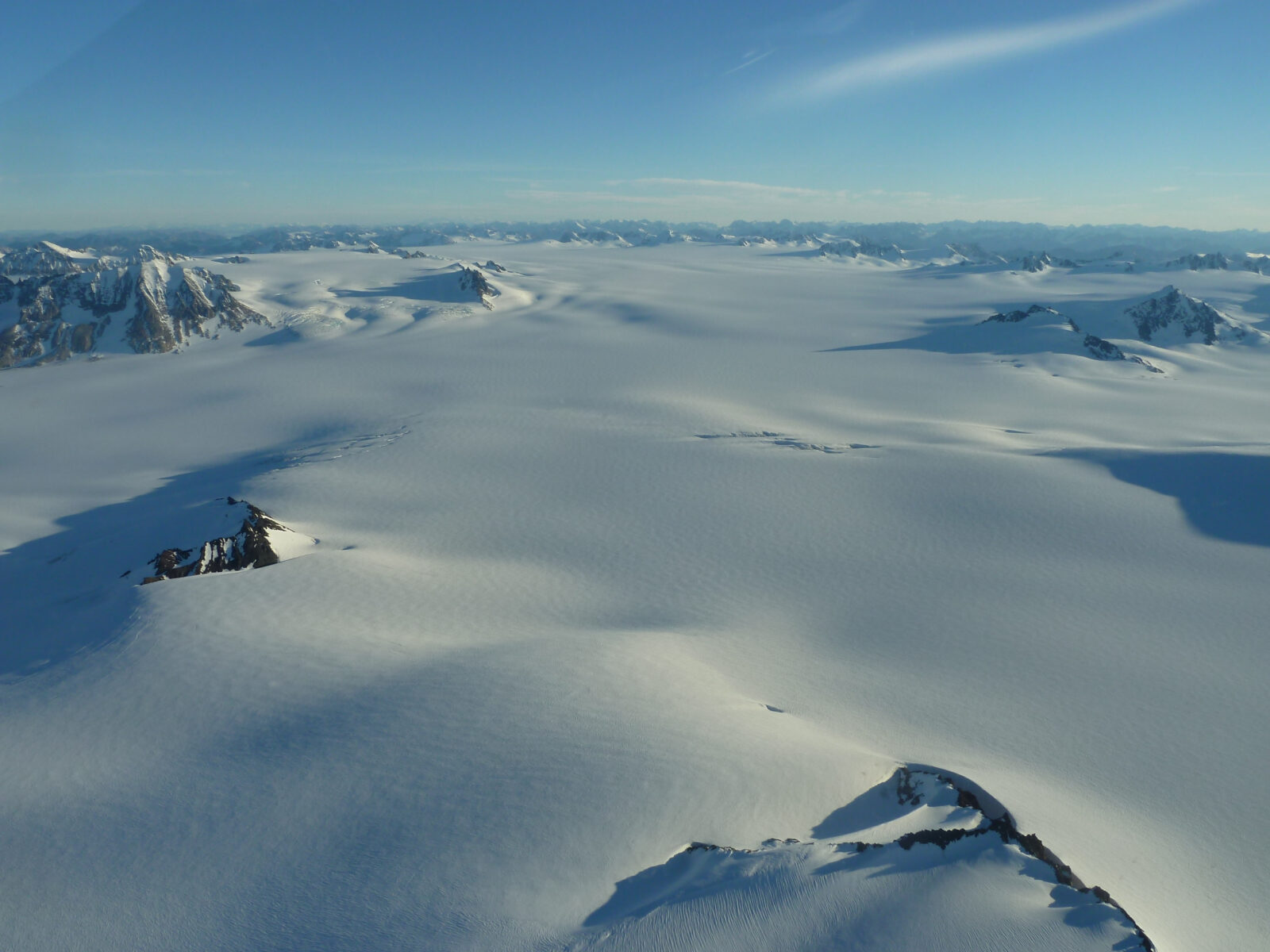
Most trails end at a view. The Harding Icefield Trail in Alaska ends at the edge of the Ice Age. After four miles of steady climbing out of the green Exit Glacier valley, the land runs out of trees, then out of plants, and then you crest a rocky rise and see it: a white plain of ice stretching to the horizon, with dark mountain tops poking through it like islands in a frozen sea.
It’s the most famous hike in Kenai Fjords National Park, and one of the best day hikes in Alaska. It’s also tough. You gain more than 3,000 feet in under four miles, snow can cover the upper trail into July, and black bears are seen along it almost every day in summer.
This guide covers everything you need: the trail map and landmarks, real distance and elevation, a section-by-section walk-through, the best viewpoints, summer and September conditions, parking and shuttles from Seward, bear safety, camping rules, and easier turnaround points if you don’t want to go all the way.
Cover photo: the Harding Icefield, with peaks rising through the ice. Photo: NPS
Season note (early November 2026): The 2026 hiking season is over. The road to Exit Glacier is not plowed in winter and usually closes to cars sometime between late October and November, once snow arrives, and the upper trail is now snow-covered avalanche terrain. The road typically reopens around mid-May. Check the park’s current conditions page before any trip.
Harding Icefield Trail: The Short Answer
The Harding Icefield Trail is a strenuous out-and-back hike of about 8 miles round trip in Kenai Fjords National Park, about 20 minutes from Seward, Alaska. It climbs roughly 3,100–3,500 feet from the Exit Glacier valley, past Marmot Meadows and the Top of the Cliffs, to an overlook of the 700-square-mile Harding Icefield. Plan 6–8 hours. The best months are July through early September; snow often covers the upper trail into July.
Harding Icefield Trail: Quick Facts
| Detail | Information |
|---|---|
| Location | Exit Glacier area, Kenai Fjords National Park, near Seward, Alaska |
| Trailhead | Exit Glacier Nature Center (end of Exit Glacier Road) |
| Distance | 7.8 miles round trip from the trail register; about 8.2 miles from the Nature Center |
| Elevation gain | About 3,100–3,500 feet (roughly 1,000 feet per mile) |
| Highest point | End-of-trail overlook, about 3,527 feet |
| Difficulty | Strenuous |
| Time needed | 6–8 hours for most hikers |
| Trail type | Out and back |
| Best months | Mid-July to early September (snow-free trail most likely) |
| Road open to cars | Usually mid-May to late October or November |
| Fees / permits | None for day hiking |
| Dogs | Not allowed on park trails |
| Water on trail | None treated; carry all you need |
Where Is the Harding Icefield Trail?
The trail starts in the Exit Glacier area, the only part of Kenai Fjords National Park you can reach by road. The rest of the park is fjords, coastline and ice that you reach by boat or plane.
From the Seward Highway, turn onto Herman Leirer Road (everyone calls it Exit Glacier Road) at Mile 3, just north of Seward. Drive about 8.4 miles to the end of the road and the Exit Glacier Nature Center. From downtown Seward it’s about a 20-minute drive. From Anchorage, plan on roughly 2.5 hours on the scenic Seward Highway.
On the drive in, look for signs with years on them along the road. They mark where Exit Glacier’s front edge used to be, and they show how far it has pulled back over the past century.
Harding Icefield Trail Map and Landmarks
From the Nature Center, walk about 0.4 miles on the paved Glacier View path to a junction, then turn right onto the Harding Icefield Trail and sign the trail register. From there, the National Park Service map lists these landmarks:
| Landmark | Distance from register (one way) | Approx. elevation | What’s there |
|---|---|---|---|
| Bridge | 0.7 mile | About 900 ft | Footbridge over a creek in the forest |
| Marmot Meadows | 1.5 miles | About 1,685 ft | First big view of Exit Glacier |
| Top of the Cliffs | 2.3 miles | About 2,454 ft | Wide view down the glacier and valley |
| Emergency shelter | 3.7 miles | About 3,456 ft | Small hut for storms only |
| End of trail | 3.9 miles | About 3,527 ft | Overlook of the Harding Icefield |
Why Does the Distance Change Between Sources?
You’ll see 7.8, 8.2, 8.4 and even 8.8 miles. They’re all “right.” The park’s map measures 3.9 miles one way from the trail register (7.8 round trip). Add the paved walk from the Nature Center and you get about 8.2 miles, which is what the park quotes on its main trail page. Phone apps and GPS watches often read a little longer because of switchbacks and wandering around at viewpoints. Plan for 8–9 miles.
Download the official map before you leave Seward. There’s little or no cell signal at the trailhead or on the trail.
How Hard Is the Harding Icefield Trail?
The park calls it strenuous, and it is. The climb is about 1,000 feet per mile, almost without a break, from the trailhead to the overlook. What makes it hard:
- Nonstop climbing: There’s no flat warm-up. You start going up in the forest and keep going up for nearly four miles.
- Rough footing: Roots, rock steps, mud and loose shale, with steep, slippery snow patches higher up.
- Snow and avalanche risk: The park warns the upper trail is often snow-covered through early July and may have avalanche danger.
- The descent: Coming down 3,000+ feet is hard on knees, especially on wet rock and snow.
- Weather: Rain, fog, wind and cold can roll in fast above the trees.
Can beginners do it? Fit beginners can enjoy the lower trail to Marmot Meadows or the Top of the Cliffs. The full hike is better for people who already do long, steep day hikes. New to the trail? Start with our hiking for beginners guide.
How Long Does It Take?
| Goal | Round-trip distance (from Nature Center) | Typical time |
|---|---|---|
| Marmot Meadows | About 3.8 miles | 2.5–3.5 hours |
| Top of the Cliffs | About 5.4 miles | 4–5 hours |
| End of trail (Harding Icefield) | About 8.2 miles | 6–8 hours |
| With snow, mud or lots of photo stops | 8+ miles | 8–10 hours |
Harding Icefield Trail: Section-by-Section Guide
1. The Forest Climb (Trailhead to the Bridge)
After the paved path and the trail register, you’re straight into a thick forest of cottonwood, alder and spruce. The trail climbs right away on roots and rock steps. It’s green, damp and often muddy. At about 0.7 miles you cross a footbridge over a creek, and soon after, the trees open a little for your first look back at the valley and the gravel outwash plain below Exit Glacier.
This is prime black bear country. Talk, sing or call out “hey bear” around blind corners, especially where berries grow along the trail.
2. Marmot Meadows (1.5 miles)
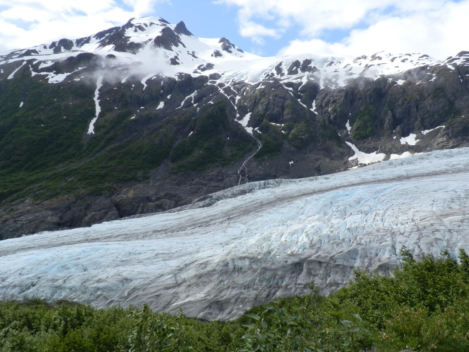
The forest gives way to brush and then to open, sloping meadows full of heather and summer wildflowers. This is Marmot Meadows, and it gives you the first great look at Exit Glacier, a river of blue-white ice spilling down beside you, with a smaller hanging glacier on the far side of the valley. Listen for the high whistle of hoary marmots, which gave the meadow its name.
Marmot Meadows is the most popular turnaround point. If the weather is poor up high or you’re short on time, it’s a very rewarding place to stop.
3. Top of the Cliffs (2.3 miles)
Above the meadows, the trail switchbacks up steeper ground with fewer plants and more rock. At the Top of the Cliffs, you’re high above Exit Glacier and can follow it all the way down the valley. On clear days you also get your first glimpse of the icefield’s edge up ahead.
This is your second good turnaround point, and the last spot where the trail is usually easy to follow early in the season. If you can see a lot of snow above you and you don’t have traction or snow experience, this is a smart place to call it a day.
4. The Upper Trail: Rock, Snow and Big Sky
Above the cliffs, the green disappears. The trail climbs over bare rock, shale and snowfields, marked with posts and cairns. Early in summer, much of this section can be under snow. It may be steep enough that a slip could mean a long slide, and the park warns of possible avalanche danger.
- Follow the posts and cairns; it’s easy to lose the trail in fog.
- Don’t cross steep snow just because others are ahead of you.
- Microspikes and trekking poles help a lot early in the season.
- Watch for mountain goats on the rocky slopes above.
At about 3.7 miles you pass a small emergency shelter. It’s there for sudden storms only. You can’t camp in it.
5. The End of the Trail: Harding Icefield
About 0.2 miles past the shelter, the trail ends on a rocky rise at roughly 3,500 feet, and the Harding Icefield opens up in front of you. It’s hard to judge the scale. The ice runs for miles, flat and white, broken only by the dark tops of buried mountains. These peaks sticking out of the ice are called nunataks.
Sit down, eat lunch, and put on every layer you brought. It’s often windy and cold up here, even in August. Then take a good look back the way you came for one more view straight down Exit Glacier.
Don’t walk out onto the icefield. The trail ends at the overlook. Beyond it are crevasses hidden under snow, and travel on the ice needs glacier gear and training.
What Is the Harding Icefield?
The Harding Icefield is a leftover from the last Ice Age. It covers the top of the Kenai Mountains so completely that only the highest peaks show through. A few numbers:
- Size: about 700 square miles of ice (the park’s 2026 fact sheet lists 695 square miles), roughly 50 miles long and 20 miles wide. It covers about half of Kenai Fjords National Park.
- Glaciers: nearly 40 glaciers flow out of it, including Exit Glacier and the tidewater glaciers you see on Kenai Fjords boat tours.
- Height: the ice surface reaches about 5,200 feet, and the tallest nunatak, Truuli Peak, rises to 6,612 feet.
- How Exit Glacier got its name: In 1968, a team crossed the icefield on foot and planned to come down this glacier at the end. A newspaper called it the “Exit” glacier, and the name stuck.
Like most glaciers in Alaska, Exit Glacier is shrinking. It has pulled back more than a mile over the past century, and the dated signs along the road and lower trails show how fast.

Best Views on the Harding Icefield Trail
| Viewpoint | What you see | Best for |
|---|---|---|
| Early openings in the forest | The valley and gravel outwash plain | Quick hikes |
| Marmot Meadows | Exit Glacier up close, hanging glacier, wildflowers | Shorter hikes, families of strong hikers |
| Top of the Cliffs | Full length of Exit Glacier and the valley | Photographers, half-day hikers |
| End of trail | The Harding Icefield panorama and nunataks | The full experience |
Where’s the best panoramic view? For the icefield itself, the end of the trail, no question. But if clouds are sitting on the upper mountain, you may get a clearer, more dramatic view of Exit Glacier from Marmot Meadows or the Top of the Cliffs. Weather matters more than elevation.
Harding Icefield Trail in Summer
| Month | What to expect |
|---|---|
| Mid-May | Road usually reopens. Deep snow up high; real avalanche risk. Lower trail only for most people. |
| June | Very long days. Snow usually still covers much of the upper trail. Bring traction or turn around at the cliffs. |
| Early July | Snow shrinking, but often still on the upper section. Wildflowers start in the meadows. |
| Mid-July to August | Best chance of a mostly snow-free trail. Peak wildflowers. Busiest time; parking fills by late morning. |
| Early September | Often snow-free, cooler, fewer people, fall colors on the slopes. |
| Late September to October | Fresh snow up high, short days, cold winds. Road can close any time once snow arrives. |
Even in July and August, Seward is a rainy place. Expect at least some rain or fog on many days, and remember it’s often 15–25°F colder and much windier at the top than in the parking lot.
Harding Icefield Trail in September
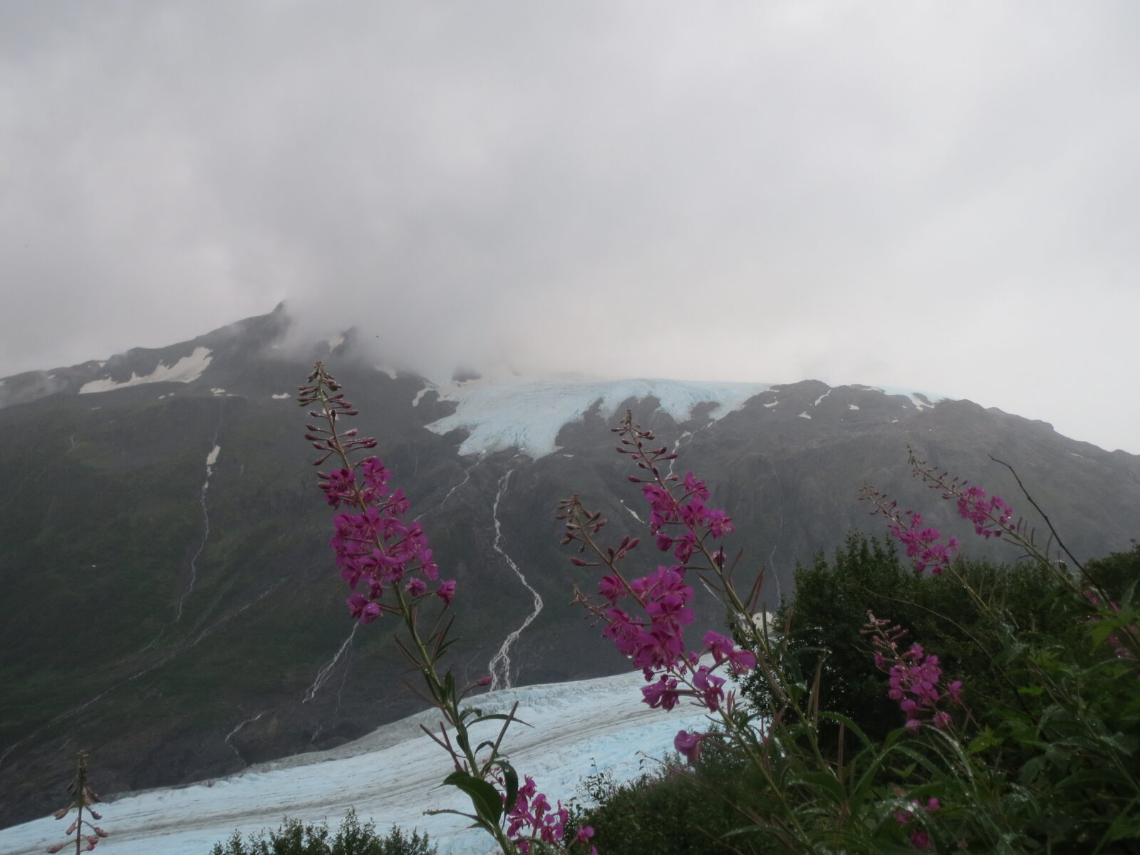
September can be the best month of all, or a total washout. On a good day you get a snow-free trail, crisp air, gold and red tundra, and far fewer people. In 2026, the park’s report from September 8 described the trail as almost completely free of snow, with just a few patches near the end.
But conditions change quickly as the month goes on:
- Daylight drops fast. Sunset moves from about 9 p.m. at the start of September to around 7:30 p.m. by the end. Start early.
- Fresh snow can coat the upper trail after any cold storm, especially late in the month.
- Services shrink. The Nature Center runs reduced hours after Labor Day, and summer shuttles and ranger programs wind down.
- Bears are busy eating berries before winter. Make plenty of noise in the brushy lower section.
Pack winter layers, gloves and a hat, and decide in advance where you’ll turn around if the weather turns.
Can You Hike It in Winter?
Not as a normal hike. From roughly November to mid-May, the road is closed to cars at a gate near the highway, and the Exit Glacier area is about 7 miles past the first gate. People reach it on skis, snowshoes, fat bikes and, when the park allows it, snowmachines. The park also rents the Willow public use cabin in the Exit Glacier area in winter.
The upper Harding Icefield Trail in winter is serious avalanche terrain. Only go up there with avalanche training, gear and a partner.
Parking, Shuttles and Getting There
- Parking: Free lot at the Exit Glacier Nature Center. The park says space is limited, especially from about 10:30 a.m. to 3:30 p.m. in summer. For the full hike, arrive by 8 a.m. anyway.
- Shuttle: In summer, a private Exit Glacier shuttle has run from Seward for about $20 round trip in recent seasons. Confirm times and book a return pickup, because there’s no cell signal to call for one.
- From Anchorage without a car: The Alaska Railroad and summer motorcoaches run to Seward. From there, use the shuttle or a taxi.
- Fees: None. There’s no entrance fee for Kenai Fjords and no permit for day hiking.
- Facilities: Restrooms and drinking water at the Nature Center in summer. Nothing on the trail.
Ranger-Led Hikes
In past summers, park rangers have led free guided hikes from the Exit Glacier Nature Center, including shorter walks on the lower trails and, on some days, a guided hike up the Harding Icefield Trail. A ranger hike is a great choice if you’re nervous about bears or hiking alone. Check the park’s ranger program schedule for the current season before you go.
Bear and Wildlife Safety
The park says black bears are spotted almost every day from the Harding Icefield Trail in summer, and brown bears also live in the area. Bears love the berries in the brushy lower section below Marmot Meadows.
- Make noise, especially on blind corners and in thick brush.
- Hike in a group and keep kids close.
- Carry bear spray where you can reach it, and know how to use it.
- If a bear is on the trail, wait. Give it plenty of space and time to move off. Never run.
- Watch for mothers with cubs and never get between them.
- Pack out all food and trash.
You may also see mountain goats on the high rocks, hoary marmots in the meadows, ptarmigan, and the occasional moose in the valley below. Enjoy them from a distance.
What to Pack
- Waterproof jacket and pants, because it rains a lot here (see our waterproof hiking jacket and rain pants guides)
- Warm layers, hat and gloves, even in July
- Sturdy hiking boots with good grip for wet rock and snow
- Trekking poles for the long descent (see budget trekking poles)
- Microspikes in June and early July
- 2–3 liters of water, plus a filter if you plan to refill from snowmelt streams
- Lunch and plenty of snacks
- Bear spray
- Offline map, headlamp, first-aid kit and a whistle
- Sunglasses and sunscreen, because sun on snow is strong
- Gaiters for snowmelt slush and mud (see our waterproof gaiters guide)
Tip: Keep your phone handy for photos in a shoulder strap phone holder, and bring a small power bank. Cold drains batteries fast at the top.
Camping Near the Harding Icefield Trail
- Backcountry camping along the trail: Allowed, but you must camp at least 1/8 mile from the trail, on bare rock or snow, to protect the fragile plants. Use bear-resistant food storage.
- Not in the emergency shelter: It’s for emergencies only.
- Exit Glacier Campground: 12 walk-in, tent-only sites near the Nature Center, first-come, first-served, when the road is open. No RVs and no pets.
- Near Seward: City campgrounds along Resurrection Bay and private RV parks.
Camping near the overlook means you can watch evening light on the icefield, which is unforgettable. But you’ll be on exposed rock or snow, so bring a strong tent and real cold-weather gear.
Are Dogs Allowed?
No. Pets aren’t allowed on any trails in the Exit Glacier area, including the Harding Icefield Trail. Leashed pets are allowed on the road and in the parking lot. Bikes also aren’t allowed on the trails. Service animals follow separate rules.
Harding Icefield Trail vs. Exit Glacier’s Shorter Trails
| Feature | Harding Icefield Trail | Exit Glacier lower trails |
|---|---|---|
| Effort | Strenuous, 3,000+ ft of climbing | Easy to moderate |
| Time | 6–8 hours | 1–2 hours |
| Main view | Harding Icefield from above | Exit Glacier from the valley |
| Accessibility | Rough, steep trail | The Glacier View Loop is paved and accessible |
| Best for | Fit, prepared day hikers | Families, rainy days, short visits |
Many visitors do both: the short Glacier View Loop on arrival day, then the Harding Icefield Trail on the clearest morning of their trip.
Sample Day Plan From Seward
- 7:00 a.m.: Breakfast in Seward and a last check of the weather and park conditions.
- 7:45 a.m.: Park at the Nature Center, sign the trail register.
- 9:00 a.m.: Marmot Meadows. Snack and decide whether to continue.
- 10:00 a.m.: Top of the Cliffs.
- 11:30 a.m.: End of the trail. Lunch with the icefield.
- 12:15–3:00 p.m.: Slow, careful descent.
- Evening: Dinner by the harbor in Seward. Your legs will thank you.
Where to Stay
Seward is the obvious base, with hotels and guesthouses around the small boat harbor, restaurants, gear shops and the boat tours into Kenai Fjords. There are also cabins and lodges along Exit Glacier Road itself, which puts you closer to the trailhead for an early start. Book well ahead for July and August.
Photography Tips
- Marmot Meadows: frame Exit Glacier with wildflowers in the foreground in July and August.
- Top of the Cliffs: a wide shot down the whole glacier and valley.
- End of trail: put a hiker or a cairn in the frame to show the icefield’s scale.
- Light: in midsummer, evening light lasts for hours and turns the ice gold.
For video, an action camera handles the rain and cold better than most phones.
Harding Icefield Trail FAQs
How long is the Harding Icefield Trail in Alaska?
About 8.2 miles round trip from the Exit Glacier Nature Center, or 7.8 miles from the trail register. GPS tracks often read 8.4–8.8 miles.
How much elevation gain is there?
Roughly 3,100–3,500 feet, depending on where you start counting. The park describes it as about 1,000 feet per mile.
How long does the hike take?
Most hikers need 6–8 hours for the full trail. Allow more in snow or bad weather.
When is the best time to hike the Harding Icefield Trail?
Mid-July through early September, when the upper trail is most likely to be free of snow.
Can you hike the Harding Icefield Trail in September?
Yes. Early September is often excellent, with little snow and fewer people. Later in the month, fresh snow, cold and short days become more likely.
Is the Harding Icefield Trail open now?
The road to Exit Glacier usually closes to cars between late October and November and reopens around mid-May. In winter, the area is reached on skis, snowshoes or fat bikes, and the upper trail is avalanche terrain. Check the park’s current conditions page.
Do you need a permit or pay a fee?
No. There’s no entrance fee for Kenai Fjords National Park and no permit for day hiking.
Can beginners hike the Harding Icefield Trail?
Fit beginners can enjoy hiking to Marmot Meadows or the Top of the Cliffs. The full trail is best for experienced hikers.
Are there bears on the trail?
Yes. The park says black bears are seen almost every day in summer. Make noise, hike in groups and carry bear spray.
Can you walk on the Harding Icefield?
Not safely without glacier gear and training. The trail ends at an overlook; hidden crevasses make the ice dangerous.
Are dogs allowed on the Harding Icefield Trail?
No. Pets aren’t allowed on Exit Glacier area trails, only on the road and in the parking lot on a leash.
Can you see the Harding Icefield without hiking the whole trail?
You’ll see Exit Glacier and glimpses of the icefield’s edge from the Top of the Cliffs. For the full panorama you need to reach the end of the trail, or take a scenic flight from Seward.
Is the Harding Icefield Trail Worth It?
Absolutely. In one day you climb from a rainforest valley, past wildflower meadows and a living glacier, to the edge of an ice sheet left over from the Ice Age. Few day hikes anywhere give you that much change in one trail.
Just go in with a flexible plan. Pick the clearest day of your trip, start early, make noise for bears, and be happy turning around at Marmot Meadows or the cliffs if the mountain says no. The icefield has been there for thousands of years. It’ll wait.