

Fall color update (October 22, 2026): Peak color in McKittrick Canyon usually lands in the last week of October and the first week of November, so the best days of 2026 are just ahead. October 27 is also a fee-free day in all national parks this year, which means the small parking lot will likely fill early. Arrive when the gate opens at 8:00 a.m., or come on a weekday. Conditions change each year, so call the park or check its alerts page before you drive out.
Most of Guadalupe Mountains National Park is rock, cactus and wind. Then there’s McKittrick Canyon. Walk a couple of miles into it and the desert gives way to a clear, spring-fed creek, Texas madrones with red bark, and bigtooth maples that turn orange and red every fall. Wallace Pratt, the geologist who once owned it, called it “the most beautiful spot in Texas.” Plenty of hikers agree.
The McKittrick Canyon Trail is also one of the most flexible hikes in the park. You can make it an easy morning walk to a 1930s stone cabin, a half-day trip to a little limestone grotto, or a real leg-burner up to a viewpoint called the Notch. This guide covers all three: distances, how hard each one is, how long it takes, the trail map, gate hours, fees, parking, fall colors, and what to pack.
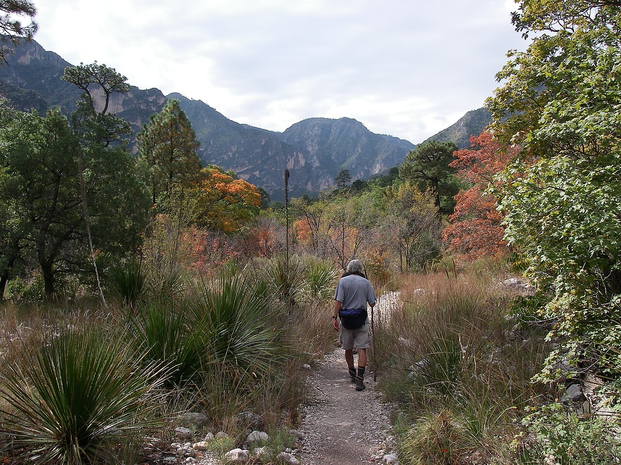
Cover photo: fall color along the trail between Pratt Cabin and the Grotto. Photo: Fredlyfish4 / Wikimedia Commons (CC BY-SA 3.0)
McKittrick Canyon Trail: Quick Facts
| Detail | Information |
|---|---|
| Location | Guadalupe Mountains National Park, West Texas |
| Trailhead | McKittrick Canyon Contact Station (visitor center at the mouth of the canyon) |
| Trailhead elevation | About 5,000 feet |
| Pratt Cabin | 4.8 miles round trip, moderate |
| The Grotto | About 7 miles round trip, moderate |
| The Notch | About 9 to 10 miles round trip, strenuous |
| Full trail | 10.9 miles one way to the Tejas Trail |
| Trail type | Out and back (same way in and out) |
| Gate hours | 8:00 a.m. to 5:00 p.m. Mountain Time, every day |
| Entrance fee | $10 per person aged 16+, valid 7 days |
| Permit | None for day hikes |
| Dogs | Not allowed on trails |
| Water on trail | None you can drink, so carry it all |
| Toilets on trail | None (restrooms at the trailhead only) |
| Best time | Late October to early November for fall colors; spring for mild weather |
How Long Is the McKittrick Canyon Trail?
The full McKittrick Canyon Trail is 10.9 miles one way, but almost nobody hikes all of it in a day. Most people pick one of three turnaround points: Pratt Cabin (4.8 miles round trip), the Grotto (about 7 miles round trip), or the Notch (about 9 to 10 miles round trip).
This is where a lot of people get confused online. Apps that list the “whole” trail show 20+ miles and 4,000 feet of climbing, because they count the full route up McKittrick Ridge to the Tejas Trail and back. That’s a backpacking trip, not a day hike. The numbers below are the hikes people actually do.
| Turnaround point | Round trip | Climbing (approx.) | Difficulty | Time |
|---|---|---|---|---|
| McKittrick Canyon Nature Trail | 0.9 mile loop | Small | Easy to moderate | 30–45 min |
| Pratt Cabin | 4.8 miles | About 500 ft | Moderate (mostly for length) | 2–4 hours |
| The Grotto + Hunter Line Shack | About 7–7.5 miles | About 800 ft | Moderate | 3–5 hours |
| The Notch | About 9–10 miles | About 1,100–1,700 ft | Strenuous past the Grotto | 5–7 hours |
| McKittrick Ridge | About 15 miles | 3,000+ ft | Very strenuous | Full day, or overnight with a permit |
Distances come from the National Park Service. The Park Service lists the Notch at 9 miles round trip with about 1,100 feet of elevation change. If you add the short side trips to Pratt Cabin and the Grotto, and count all the small ups and downs, GPS tracks usually show closer to 10 miles and 1,500 to 1,700 feet of total climbing.
McKittrick Canyon Trail Map and Elevation Profile
The route is simple: one trail heads west up the canyon floor, with short signed spurs to Pratt Cabin and the Grotto, then climbs switchbacks to the Notch.
Trailhead → Pratt Cabin (2.4 mi) → the Grotto (about 3.5 mi) → Hunter Line Shack (a few minutes past the Grotto) → the Notch (about 4.5 mi)

The elevation chart tells the real story. The first 3.5 miles barely look like a climb at all. After the Grotto, the line shoots up.
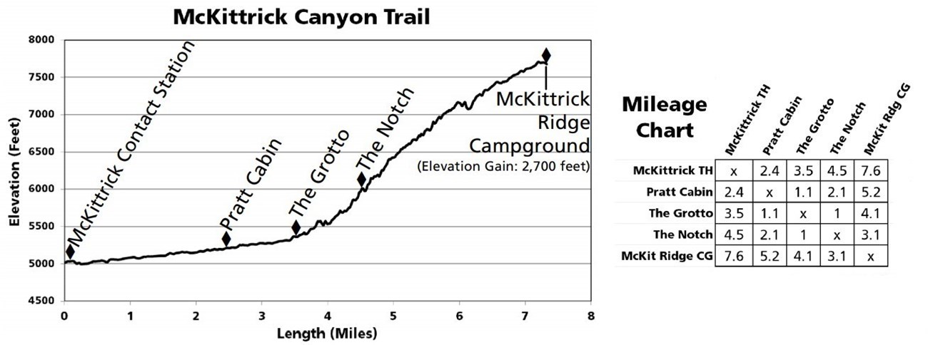
Tip: There’s no cell service in the canyon. Take a screenshot of the map, or download an offline map, before you leave town. You can also pick up a paper park map at the contact station.
Where Is McKittrick Canyon?
McKittrick Canyon is in the northeast corner of Guadalupe Mountains National Park, in far West Texas right below the New Mexico line. It has its own entrance, separate from the main Pine Springs area where Guadalupe Peak and Devil’s Hall start.
- From Pine Springs Visitor Center: drive about 7 miles north on US-62/180, turn left at the McKittrick Canyon sign, then follow the paved side road about 4 miles to the end. Allow 15–20 minutes.
- From Carlsbad, New Mexico: about 50 miles southwest on US-62/180, roughly an hour.
- From Carlsbad Caverns National Park / Whites City: about 40 minutes.
- From El Paso, Texas: about 115 miles east, roughly 2 hours.
The side road is paved and fine for any car. There’s no gas, food or store anywhere in the park, so fill up in Carlsbad, Whites City, El Paso or Van Horn.
Gate Hours: The Rule That Catches People Out
McKittrick Canyon is day-use only. The gate on US-62/180 opens at 8:00 a.m. and is locked at 5:00 p.m. Mountain Time, every day. You can’t start before 8, and you must be back in your car and out before 5.
- You may see old hours online. Older guides list 6 p.m. in summer and 4:30 p.m. in winter. The Park Service now lists 8 to 5 year-round, but check before you go.
- The park runs on Mountain Time, one hour behind most of Texas. Near the state line your phone can switch zones on its own, so set your watch by park time.
- Do the math for the Notch. If the hike takes you 6 to 7 hours, you need to be walking by about 9:30 a.m. at the latest.
At the Trailhead
The road ends at a parking lot and the small McKittrick Canyon Contact Station. There are restrooms, a few outdoor exhibits, and a fee station. These are the last toilets you’ll see. There are no restrooms or trash cans inside the canyon.
Walk through the building to the back and you’ll find three trails starting side by side:
- Middle: McKittrick Canyon Trail. The wide one covered in white gravel. This is your trail.
- Left: McKittrick Canyon Nature Trail. A short loop with signs about desert plants.
- Right: Permian Reef Trail. A steep climb up the ridge (see “Other hikes” below).
The Hike Step by Step
1. Trailhead to Pratt Cabin (2.4 miles)
The first stretch is the easiest part of the whole trail, and the most exposed. The path is wide white gravel, and it climbs so gently you’ll hardly notice. Big limestone walls rise on both sides, and the open desert is behind you.
You’ll cross dry washes several times, and the creek itself about twice. Depending on recent rain, the crossings may be dry or have a few inches of water over the rocks. A little past the first creek crossing, the first tall maples show up along the water. There isn’t much shade on this part, so wear a hat.
Right around the 2-mile mark, a small metal sign points right to Pratt Cabin. It’s a two-minute walk off the main trail.
2. Pratt Cabin
Pratt Cabin sits right where the north and south forks of McKittrick Canyon meet. Oil geologist Wallace Pratt had it built over the winter of 1931–32 as a summer escape from Houston. The walls and even the roof are limestone, quarried a few miles away and hauled in by pickup truck and horse-pulled sled. Pratt never liked the name “Pratt Lodge” that later stuck. He just called it the Stone Cabin.
In the early 1960s, Pratt donated more than 5,000 acres of the canyon, including this cabin, to the National Park Service. That gift helped create the national park in 1972. The cabin went on the National Register of Historic Places in 1975.

What you’ll find here: a shady porch, stone picnic tables, and a good spot for lunch. Can you go inside? Only when a volunteer or ranger is there. On fall weekends, volunteers often staff the cabin and answer questions. There’s no toilet or drinking water at the cabin.
Should you turn around here? If you have small kids, limited time, or you mainly came for a nice walk and some color, yes. Pratt Cabin is the classic McKittrick hike, and in a good year you can see fall color right from the porch.
3. Pratt Cabin to the Grotto (about 1.1 miles more)
This is the prettiest part of the canyon floor, and the part many hikers say they liked most. Past the cabin you enter the designated wilderness. The gravel road-like path ends and becomes a narrower dirt trail, rockier in spots. Trees close in overhead: maples, oaks, junipers, and Texas madrones with their smooth, peeling red bark.
You’ll walk near the creek, which runs year-round here. It’s the only real flowing stream in the whole park. Look into the clear pools and you may spot small fish. The trail still climbs gently, and this shady stretch feels much cooler than the first two miles.
4. The Grotto and Hunter Line Shack
About 3.5 miles from the trailhead, a signed spur heads left and downhill for 2 to 3 minutes to the Grotto. Don’t expect a real cave. It’s a shallow overhang in the limestone cliff, with rock drips that look like small stalactites and stalagmites. It’s a cool, shady place to sit, and there’s a cluster of stone picnic tables just past it.
Keep going another 4 to 5 minutes and you reach Hunter Line Shack, an old stone ranch building from the days when cowboys worked cattle in the canyon. It’s worth the few extra steps.
Please don’t touch the formations or climb on the Grotto walls. Skin oils stop the formations from growing, and they took thousands of years to form.
For most people, the Grotto is the sweet spot: long enough to feel like a real hike, still easy on the legs, and it takes you through the best part of the canyon.
5. The Grotto to the Notch (about 1 mile, steep)
Back on the main trail, things change fast. The trail leaves the canyon floor and starts climbing up the side of McKittrick Ridge in tight switchbacks. Expect big rock steps, loose stones, and some spots where you’ll use your hands for balance. It’s the kind of climb that has you stopping “for the view” every few minutes.
The last quarter mile is the hardest: the steepest, narrowest and rockiest part of the whole hike. Then you squeeze through a gap in the rock, and that’s the Notch.

6. At the Notch
From the Notch you look both ways at once: back down McKittrick Canyon toward the desert you started in, and west into South McKittrick Canyon. In fall, this is where you see the color best, with whole slopes of red and gold below you instead of one tree at a time. The Park Service itself says the best fall views need the longer hike to the Notch or the ridge.
Most day hikers turn around here. The trail keeps climbing toward the McKittrick Ridge backcountry campsite, gaining much more elevation. That section is very strenuous and is best done as an overnight trip with a wilderness permit from the Pine Springs Visitor Center.
Going down: take the switchbacks slowly. Loose rock on a steep downhill is where tired hikers slip. Trekking poles help a lot here. Once you’re back on the canyon floor, the last 3.5 miles are easy cruising.
Which Hike Should You Choose?
| If you are… | Go to | Why |
|---|---|---|
| A family with young kids | Nature Trail or Pratt Cabin | Short, gentle, picnic tables at the end |
| A casual hiker with half a day | Pratt Cabin | History, creek crossings, a little color |
| A regular hiker | The Grotto | Takes you through the shadiest, most scenic part of the canyon |
| A fit hiker chasing fall color | The Notch | The best views of color across whole slopes |
| Short on time | Pratt Cabin | Back in 2–3 hours with time for another hike |
How Hard Is the McKittrick Canyon Trail?
To Pratt Cabin and the Grotto, it’s a moderate hike: long but gentle, with no steep climbs. Past the Grotto, the climb to the Notch is steep, rocky and strenuous. The Park Service rates Pratt Cabin “moderate due to length” and the Notch “difficult past the Grotto.”
What makes the easy part harder than it looks:
- Loose gravel on the first two miles tires your feet more than a smooth path.
- Sun. The first two miles have very little shade.
- Distance. Five miles is a long walk if you don’t hike often.
- Elevation. You start around 5,000 feet, so you may breathe harder than at home.
Can beginners hike McKittrick Canyon?
Yes. The walk to Pratt Cabin is one of the best beginner hikes in the park, as long as you’re comfortable walking about 5 miles and bring enough water. Leave the Notch for when you have a few more hikes behind you. If you’re just starting out, our hiking for beginners guide covers what to wear and pack.
Is it good for kids?
Very. Kids who walk a few miles at home usually do fine to Pratt Cabin, and the creek crossings and the Grotto keep them interested. Watch them near the water, since the rocks can be slick, and keep everyone on the trail. Toddlers will need a carrier for most of the way.
McKittrick Canyon Fall Colors
Fall color in McKittrick Canyon usually peaks in the last week of October and the first week of November. The season as a whole runs from about mid-October to mid-November, and the exact timing changes each year with rain and temperature.
Why does a desert canyon turn color at all? The high canyon walls block the hottest sun, and the year-round creek keeps the ground moist. That lets trees grow here that you’d normally see much farther north. The main show comes from bigtooth maples (bright red and orange), with yellow and bronze from chinquapin oaks, ash and walnut. Texas madrones add red bark and, by fall, bright red berries.
- Where the color is: mostly along the creek, starting a little past the first crossing, and thickest between Pratt Cabin and the Grotto.
- Best views: from the Notch, where you look down on color across whole slopes.
- Little color near the trailhead. All the good displays need you to hike in.
- Want to beat the crowds? Upper Dog Canyon, on the park’s north side, often turns a week or two earlier. Devil’s Hall and Smith Spring near Pine Springs also get some color.
- Not on Guadalupe Peak. There’s little to no fall color on that trail.
Fall crowd tips
Color weekends are the busiest days of the year here, and the McKittrick lot is small. When it’s full, you may have to wait or go elsewhere. To have the best day:
- Come on a weekday if you can. The Park Service asks visitors to do this.
- Be at the gate at 8:00 a.m. Early hikers often have the canyon nearly to themselves on the way in.
- Carpool to save a parking space.
- Have a backup plan, like Smith Spring or the Pine Springs trails, in case the lot is full.
Best Time to Hike McKittrick Canyon (By Season)
| Season | What it’s like | Our take |
|---|---|---|
| Spring (March–May) | Mild days, fresh green leaves, strongest creek flow; very windy at times, busy over spring break | Excellent. Arrive at 8 a.m. in March |
| Summer (June–August) | Hot on the open first two miles, afternoon thunderstorms possible | Fine for Pratt Cabin if you start at 8 a.m.; carry extra water |
| Fall (September–November) | Mild weather (often in the 60s°F) and the famous fall colors | The best time, and the most crowded |
| Winter (December–February) | Cold mornings, pleasant afternoons, very quiet; snow or ice possible higher up | Great for solitude; take care on the Notch switchbacks |
Weather in the Guadalupes can change fast. Check the forecast for the park itself, not for El Paso or Carlsbad, and leave the Notch for another day if thunderstorms or high winds are coming.
Entrance Fees and Parking
- Entrance fee: $10 per person aged 16 and older, good for 7 days anywhere in the park. Kids under 16 are free.
- Annual park pass: $35.
- America the Beautiful pass: covers your entry.
- Where to pay: at the McKittrick Canyon Contact Station or the self-pay station at the trailhead (cash or card). Put your stub on the dashboard.
- Free days left in 2026: October 27 and November 11 (Veterans Day), for US citizens and residents.
- No permit or reservation is needed for a day hike. Camping on McKittrick Ridge needs a wilderness permit.
Parking is only at the lot at the end of the road. It’s free but limited, with accessible spaces. Don’t park along the side road. On fall weekends the lot can fill by mid-morning.
What to Bring
| Item | Why |
|---|---|
| Water: 2 liters for Pratt Cabin, 3+ liters for the Notch | There’s no drinking water in the canyon. Don’t drink from the creek. |
| Shoes with good grip | Trail runners are fine to the Grotto; hiking shoes are better for the Notch |
| Trekking poles | The Park Service recommends them for the loose rock, and they save your knees on the way down |
| Sun hat, sunglasses, sunscreen | The first two miles are in full sun |
| Light jacket or fleece | Cool mornings in fall, and wind at the Notch |
| Lunch and snacks | There’s no food in the park; the picnic tables are a perfect lunch stop |
| Offline map | No cell service |
| Small first-aid kit | For blisters and scrapes |
| Trash bag | No trash cans in the canyon; pack out everything |
Gear that helps on this trail
You don’t need fancy gear for McKittrick Canyon, but a few things make the day easier, especially if you’re heading to the Notch:
- Trekking poles for the rocky switchbacks. See our picks for the best budget trekking poles for beginners and the best hiking poles for women.
- A light rain or wind jacket for cool fall mornings and windy ridges. Compare options in our best waterproof hiking jacket guide.
- A small camera for the fall colors. Our best action cameras for hiking guide covers light, tough options.
Rules and Tips for Protecting the Canyon
- Stay on the trail. Foot traffic in McKittrick Canyon is limited to the trail to protect the creek and the plants around it.
- Stay out of the creek. No wading or swimming. Cross only where the trail crosses.
- No pets on any park trail. Only trained service animals are allowed.
- Don’t pick leaves or collect rocks and fossils.
- Watch for rattlesnakes in warm months, and give mule deer and other wildlife plenty of space.
- Pack out all trash, including fruit peels.
Photography Tips
- Shoot the maples with the sun behind them. Backlit leaves glow. Mid-morning, when the sun first clears the canyon walls, is great for this.
- Use the cliffs as a backdrop. Red leaves against pale limestone is the classic McKittrick shot.
- Look down at the creek. Fallen leaves in the clear pools make great close-ups.
- Save some battery for the Notch, where you get the wide views.
Other Hikes Near McKittrick Canyon
| Hike | Distance | Difficulty | Why go |
|---|---|---|---|
| Permian Reef Trail | About 8.4 miles round trip | Strenuous | Starts at the same trailhead; climbs through an ancient fossil reef to big views over McKittrick Canyon, with far fewer people |
| McKittrick Canyon Nature Trail | 0.9 mile loop | Easy to moderate | Quick look at desert plants with signs |
| Guadalupe Peak | 8.4 miles round trip | Very strenuous | The highest point in Texas |
| Devil’s Hall | 4.2 miles round trip | Moderate | Rock-hopping up a wash to a narrow stone “hallway” |
| Smith Spring Loop | 2.3 miles | Easy to moderate | A shady desert spring, and some fall color |
If you enjoy desert hiking in Texas, the Lost Mine Trail in Big Bend is another great one, about four hours south.
Where to Stay Near McKittrick Canyon
There are no hotels or lodges inside Guadalupe Mountains National Park, so you’ll either camp or stay in a nearby town. Since the gate doesn’t open until 8 a.m., staying close isn’t as important here as it is for Guadalupe Peak.
- Pine Springs Campground: inside the park, about 20 minutes from the McKittrick trailhead. Tent and RV sites; book ahead in fall and spring.
- Dog Canyon Campground: on the park’s quiet north side, about 2 hours’ drive from Pine Springs.
- Whites City, New Mexico: the closest motel and RV stays, about 40 minutes away, right by Carlsbad Caverns.
- Carlsbad, New Mexico: the most choice of hotels, restaurants and groceries, about an hour away. The best base if you’re also visiting Carlsbad Caverns.
- Van Horn, Texas: a small highway town about an hour south of Pine Springs, handy if you’re coming from Big Bend.
Where to Eat
There’s no food for sale in the park. Pack a lunch and eat at the picnic tables at Pratt Cabin or by the Grotto. Buy groceries and snacks in Carlsbad, Whites City or El Paso the day before. After your hike, Carlsbad has the closest sit-down restaurants.
Sample Itineraries
One day: McKittrick Canyon (easy to moderate)
| Time (Mountain) | Plan |
|---|---|
| 7:45 a.m. | Be waiting at the gate on US-62/180 |
| 8:15 a.m. | Pay the fee, use the restroom, start hiking |
| 9:30 a.m. | Pratt Cabin: short rest on the porch |
| 10:15 a.m. | The Grotto and Hunter Line Shack |
| 11:00 a.m. | Picnic lunch by the Grotto |
| 1:00 p.m. | Back at the car |
| Afternoon | Smith Spring or Frijole Ranch near Pine Springs, or drive to Carlsbad Caverns |
Doing the Notch instead? Start at 8:15 a.m., reach the Notch around 11:30 a.m., and you’ll be back by about 2:30 p.m., with plenty of buffer before the 5:00 p.m. gate.
Two days in Guadalupe Mountains
- Day 1: Guadalupe Peak at sunrise (it doesn’t have a gate), or Devil’s Hall if the wind is too strong for the summit.
- Day 2: McKittrick Canyon to the Grotto or the Notch. Your legs will thank you for doing the easier canyon hike after the peak.
With a third day, add Carlsbad Caverns, about 40 minutes north. It makes this a great West Texas and New Mexico road trip.
Is the McKittrick Canyon Trail Worth It?
Yes, especially in fall. Few places in Texas let you walk from desert into a maple-lined canyon with a year-round creek in an hour. It’s also one of the rare hikes that works for everyone in a group, since some can stop at the cabin while others push on to the Notch.
Be honest with yourself about what you want, though. Outside of fall, the first two miles are fairly plain and sunny. If big views matter more to you than shady creekside walking, the Permian Reef Trail from the same parking lot may suit you better. And on peak color weekends, expect company.
McKittrick Canyon Trail FAQs
How long is the McKittrick Canyon Trail?
The full trail is 10.9 miles one way to the Tejas Trail. Most people hike to Pratt Cabin (4.8 miles round trip), the Grotto (about 7 miles), or the Notch (about 9 to 10 miles).
How long does it take to hike to Pratt Cabin?
The Park Service estimates 2 to 4 hours round trip. Most people take about 3 hours with a break at the cabin.
How hard is the hike to the Notch?
It’s strenuous. The first 3.5 miles are gentle, but after the Grotto the trail climbs steep, rocky switchbacks, and the last quarter mile is the hardest. Plan on 5 to 7 hours round trip.
What time does McKittrick Canyon open and close?
The gate opens at 8:00 a.m. and is locked at 5:00 p.m. Mountain Time. You must be out of the canyon before it closes.
When are the fall colors in McKittrick Canyon?
Usually the last week of October and the first week of November, with some color from mid-October to mid-November. Timing changes every year with the weather.
Do you need a permit or reservation?
No permit or reservation is needed for a day hike. You only need the park entrance fee of $10 per person aged 16 and older. Overnight camping on McKittrick Ridge needs a wilderness permit.
Can you go inside Pratt Cabin?
Only when a volunteer or ranger is there, which is common on fall weekends. You can always use the porch and picnic tables.
Is there water on the McKittrick Canyon Trail?
There’s a creek, but no safe drinking water, and you’re asked to stay out of the stream. Carry all the water you need.
Are dogs allowed in McKittrick Canyon?
No. Pets aren’t allowed on any trails in Guadalupe Mountains National Park. Only trained service animals are allowed.
Is McKittrick Canyon good for beginners?
Yes. The hike to Pratt Cabin is gentle and a good choice for beginners and families. The Notch is better for experienced hikers.
Final Thoughts
McKittrick Canyon is the surprise of Guadalupe Mountains: a green, creek-fed canyon tucked inside a desert. Go to Pratt Cabin for an easy walk with some history, the Grotto for the best of the canyon floor, or the Notch if you want the big fall views and don’t mind a climb.
Whatever you choose, get there when the gate opens at 8, carry plenty of water, and keep one eye on the clock. That 5 p.m. gate doesn’t wait for anyone.