

Season update (October 2026): The Loop Road at Craters of the Moon, where the Inferno Cone trailhead sits, usually closes to cars by mid-November once snow arrives, and reopens around mid-April. As of the park’s October 7, 2026 conditions report, the visitor center, Lava Flow Campground and the Indian Tunnel and Dewdrop caves were all open. October 27 and November 11 are fee-free days this year. If you’re visiting late in the fall, call the park at 208-527-1300 to check the road before you drive out.
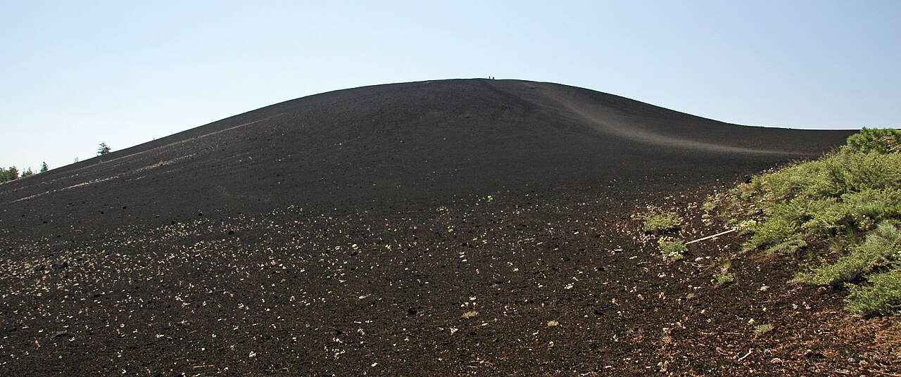
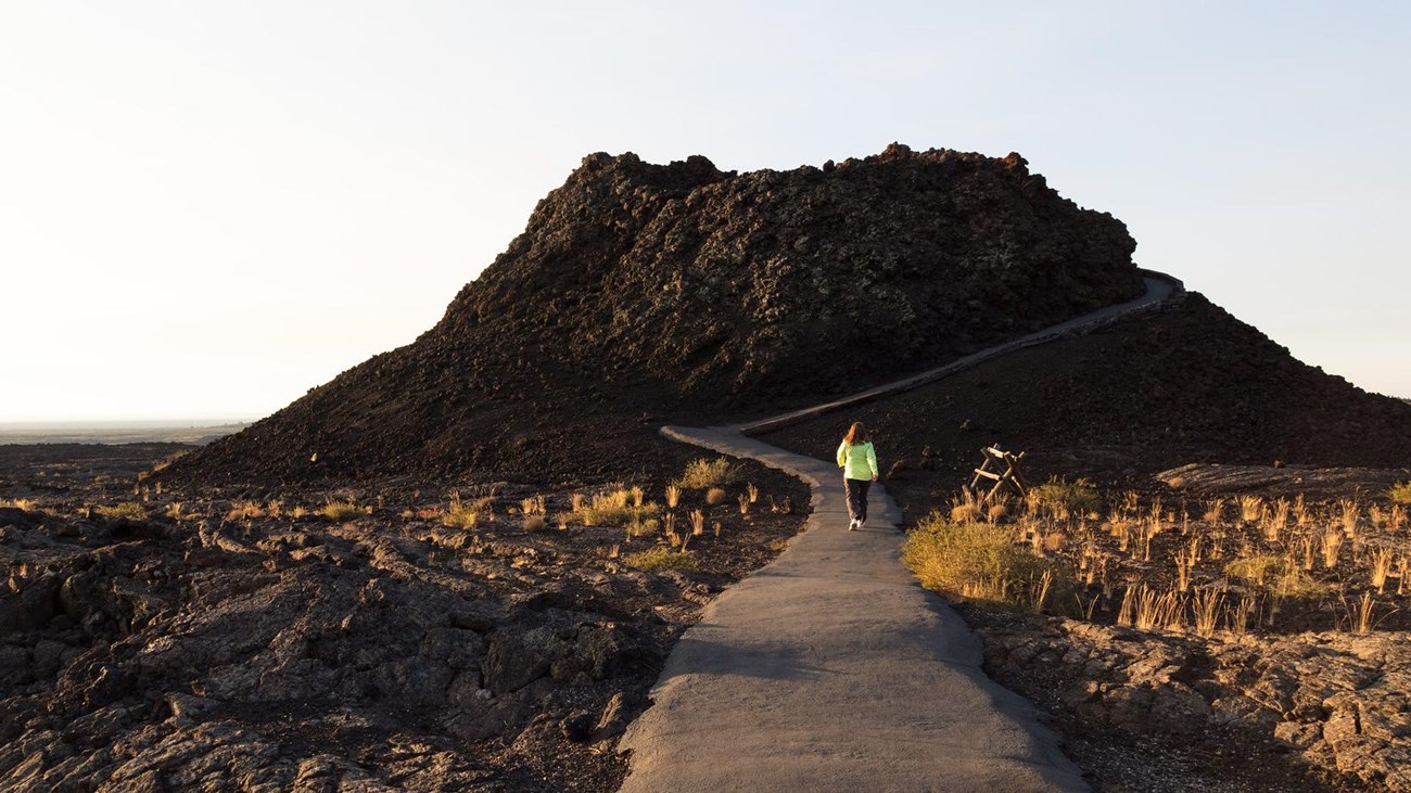
From the parking lot, Inferno Cone looks like a giant pile of black coffee grounds. A pale line runs straight up the middle of it. That’s the trail. No trees, no switchbacks, no shade. Just you, a steep slope of crunchy volcanic cinders, and the sky.
It only takes about 10 minutes to reach the top, but your legs will notice. And when you get there, the view is wild. Black lava flows spread out in every direction, a line of volcanoes marches across the plain, and snowy mountains rise in the distance. On a very clear day, you can even spot the Grand Tetons, about 100 miles away. No wonder NASA brought Apollo astronauts here to study volcanic geology before they went to the Moon.
The Inferno Cone Trail is the best short hike in Craters of the Moon National Monument and Preserve, and the one stop most visitors remember. This guide covers the distance, how hard it really is, how long it takes, parking, the best time to go, what you’ll see from the summit, why there’s no crater on top, and how to fit it into a day on the Loop Road.
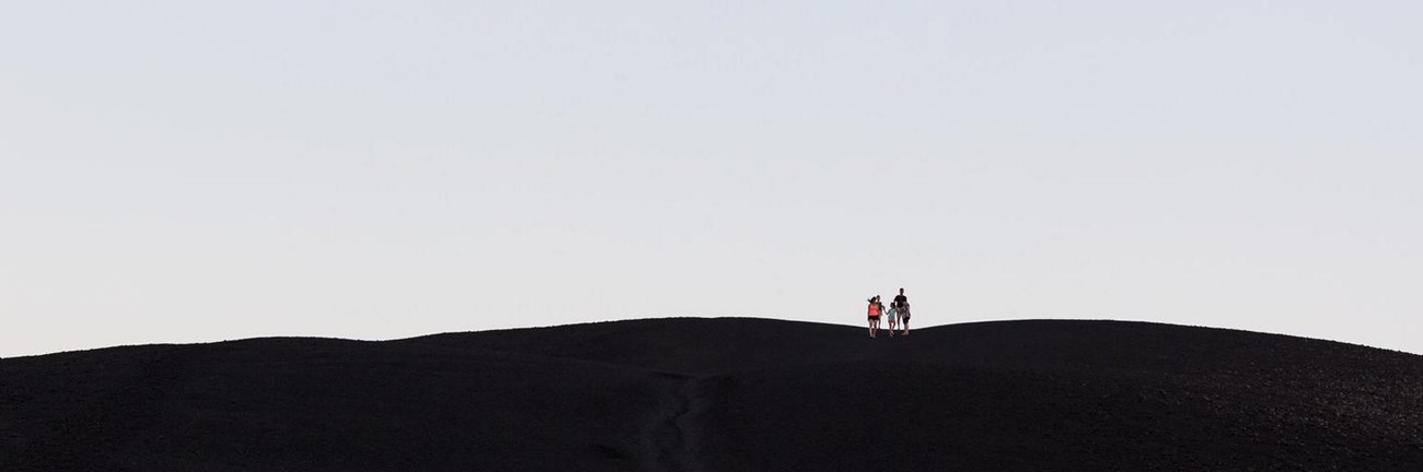
Cover photo: hikers starting the climb up Inferno Cone. Photo: NPS
Inferno Cone Trail: Quick Facts
| Detail | Information |
|---|---|
| Location | Craters of the Moon National Monument and Preserve, south-central Idaho |
| Trailhead | Inferno Cone parking area on the Loop Road, about 2.5 miles from the visitor center |
| Distance | 0.4 mile round trip (0.2 mile each way) |
| Elevation gain | 164 feet |
| Summit elevation | About 6,181 feet |
| Time | 30 to 45 minutes, including time on top |
| Difficulty | Short but very steep (moderate) |
| Trail surface | Firm, gravel-like volcanic cinders |
| Trail type | Out and back, straight up and down |
| Shade | None |
| Entrance fee | $20 per vehicle, good for 7 days (free when the Loop Road is closed for winter) |
| Permit | None needed |
| Dogs | Not allowed on the trail |
| Restroom and water | None at the trailhead; water only at the visitor center |
| Best time | May to early June and September to October; early morning in summer |
How Long Is the Inferno Cone Trail?
The Inferno Cone Trail is 0.4 mile round trip, with 164 feet of elevation gain. You walk about 0.2 mile straight up the side of the cone, then come back down the same way. The Park Service suggests allowing 30 to 45 minutes.
Some hiking websites list it as 0.5 mile or even 1 mile. That usually includes walking around on the wide summit. The climb itself is short. Most people reach the top in 5 to 15 minutes, then spend the rest of their time soaking in the view.
| Type of visitor | Round-trip time (rough guide) |
|---|---|
| Fit hiker, quick look | 15 to 25 minutes |
| Average visitor | 30 to 45 minutes |
| Photographer | 45 to 60 minutes |
| Family with young kids | 45 minutes to an hour |
Where Is the Inferno Cone Trail?
Inferno Cone is inside Craters of the Moon National Monument and Preserve, in south-central Idaho. The park sits on US Highway 20/26/93 between the small towns of Arco and Carey. The trail is one of the stops on the park’s paved Loop Road, a 7-mile scenic drive that starts at the Robert Limbert Visitor Center.
Driving times to the park
| From | Distance (approx.) | Drive time (approx.) |
|---|---|---|
| Arco, ID | 18 miles | 20 minutes |
| Carey, ID | 25 miles | 25 minutes |
| Sun Valley / Ketchum, ID | 85 miles | 1.5 hours |
| Idaho Falls, ID | 90 miles | 1.5 hours |
| Twin Falls, ID | 90 miles | 1.5 to 2 hours |
| Boise, ID | 190 miles | 3 hours |
| West Yellowstone, MT | 195 miles | 3.5 hours |
The park is a very popular stop on Yellowstone road trips. If you’re driving between Yellowstone and Boise or Sun Valley, it’s only a small detour, and Inferno Cone is the perfect way to stretch your legs. Planning that kind of trip? See our Yellowstone and Grand Teton road trip guide.
How to get to the trailhead
- Turn off US-20/26/93 at the park entrance, about 18 miles southwest of Arco.
- Stop at the visitor center. Pick up a park map, fill your water bottles (this is the only drinking water in the park), and get a cave permit if you want to visit the lava tubes later.
- Pay the entrance fee at the entrance booth or fee machine on the Loop Road (credit card only).
- Drive the Loop Road past North Crater Flow and Devils Orchard. You can’t miss Inferno Cone. It’s the huge black hill on the left.
- Park in the Inferno Cone lot. The trail starts right at the base of the cone.
The Loop Road is paved and fine for any car. The parking lot also has room for RVs and buses, though it can get busy on summer afternoons. There’s no shade in the lot, so never leave pets or kids in the car. The park says air temperatures top 90°F in midsummer, and the black rock can reach 150°F.
The Hike Step by Step
There’s nothing complicated about this trail. You can see the whole route from your car. It goes straight up, and it comes straight down.
1. The bottom of the cone
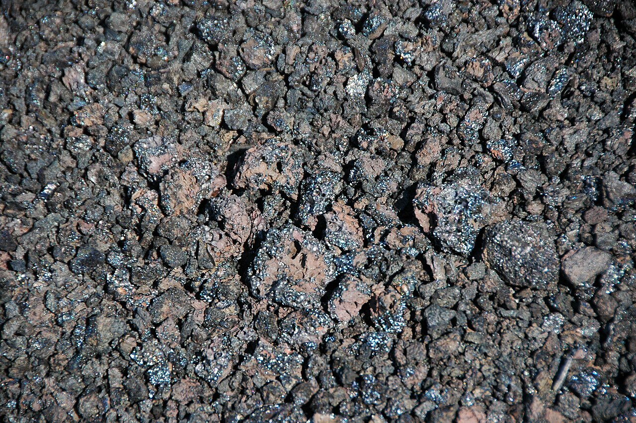
The trail starts right next to the parking lot. Up close, the cone isn’t just black. Look down and you’ll see the cinders shine in shades of black, deep purple and rusty red. Some of them sparkle in the sun. They’re light and full of tiny holes, because they formed from gassy lava that was thrown into the air and cooled before it landed.
Before you start, look up and pick your pace. The slope looks short, and it is. But it’s steeper than it looks from the car.
2. The climb
This is the hard part, and it’s over fast. The trail heads straight up the face of the cone with no switchbacks. The Park Service measures most of the trail at an 8% to 28% grade, which is far steeper than a wheelchair ramp. The path is wide and firm, packed with small cinders and rocks up to about 4 inches across.
Take short steps and don’t race. Stop and turn around now and then. Partly to catch your breath, but mostly because the view behind you gets better with every step. You’re at about 6,000 feet, so if you live near sea level, you’ll feel the thin air.
3. The summit
The top is a surprise. Instead of a sharp peak or a crater, you’ll find a broad, rounded summit with a few hardy plants: sagebrush, rabbitbrush, a few wildflowers in early summer, and a couple of twisted limber pines and junipers. Notice how the trees lean? That’s the wind, and it rarely stops up here.
Walk slowly around the top for the full 360-degree view (see what to look for below). Stay on the paths that other people have worn, and don’t build rock piles or collect cinders. Everything here is protected.
4. Coming back down
Going down is easier on your lungs and harder on your feet. Loose cinders can roll under your shoes like marbles. Keep your weight over your feet, take small steps, and resist the urge to run, even though kids always want to. If you have trekking poles, this is where they help.
How Hard Is the Inferno Cone Trail?
The Inferno Cone Trail is short but very steep. The park brochure calls it moderate, and the Park Service’s own trail page describes it as “short but extremely steep.” For most healthy people, it’s a quick, sweaty workout rather than a real hike. Judge it by the steepness, not the distance.
What makes it harder than it looks:
- The grade. Almost all 164 feet of climbing happen in a very short distance.
- Loose cinders. They make the downhill slippery.
- Heat. Black rock soaks up the sun. On summer afternoons, the slope can feel like an oven.
- Wind. The summit is completely exposed, and strong gusts are common.
- Altitude. At around 6,000 feet, you’ll breathe harder than at home.
There’s no scrambling, no exposure to big drops, and no special gear needed.
Is it good for beginners?
Yes. Because it’s so short, you can stop as often as you like. If you can climb a few flights of stairs, you can do this. Wear shoes with grip, carry water and go at your own pace. New to hiking? Our hiking for beginners guide covers the basics.
Can you hike Inferno Cone with kids?
Absolutely. Kids love climbing a real volcano, and the short distance keeps whining to a minimum. Hold small hands on the way down, since loose cinders and running kids don’t mix. Bring water even for this short climb, and go early on hot days. Strollers won’t work here. If anyone in your group doesn’t want to climb, the view from the parking lot is still impressive.
Is Inferno Cone wheelchair accessible?
No. The grade is far too steep. For accessible volcanic scenery, try the paved Devils Orchard Nature Trail or the North Crater Flow Trail, both nearby on the Loop Road.
Can you bring a dog?
No. Pets aren’t allowed on trails or in caves at Craters of the Moon. The sharp, hot lava rock is hard on paws anyway. Leashed pets can go on paved roads, in parking areas and in the campground.
What You’ll See From the Top of Inferno Cone
This is the best viewpoint you can reach easily in the whole park. Here’s what to look for.
| Look… | What you’ll see |
|---|---|
| South | Big Cinder Butte, one of the largest basalt cinder cones in the world, and a long row of cones along the Great Rift |
| East | Huge black lava fields stretching across the Snake River Plain; on the clearest days, the Teton Range about 100 miles away |
| West | More cinder cones, including the Snow Cone and Spatter Cones area |
| North | The rugged Pioneer Mountains, often still snowy in early summer |
| Below you | The Loop Road, Devils Orchard and the parking lot, looking tiny |
The Great Rift
From the summit, notice how many of the cones line up, like beads on a string. That line traces the Great Rift, a chain of cracks in the Earth’s crust that runs about 60 miles across southern Idaho. Lava poured out of these cracks again and again, building the cones and lava flows you see. Inferno Cone is one of the best places in the park to see this pattern with your own eyes.
Big Cinder Butte
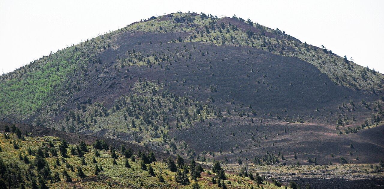
The big, rounded hill to the south is Big Cinder Butte, the tallest cone in the park at about 6,515 feet. It’s one of the largest purely basaltic cinder cones on Earth. From Inferno Cone you get a great sense of its size. There’s no trail to the top, so this is the best view of it most people will ever get.
The Pioneer Mountains and the Tetons
To the north, the Pioneer Mountains rise sharply from the edge of the lava. They make a great backdrop for photos, especially when they still have snow in May and June. And if the air is very clean, look far to the east for a faint, jagged line on the horizon. Those are the Tetons, roughly 100 miles away. Haze or wildfire smoke often hides them in late summer, so don’t be disappointed if you can’t see them. If they’ve caught your eye, our guide to the best hikes in Grand Teton National Park covers them up close.
Why Doesn’t Inferno Cone Have a Crater?
Most people expect to look down into a crater at the top. Instead, they find a flat, rounded summit. Here’s why.
When the eruption happened, lava fountains threw frothy blobs of molten rock high into the air. They cooled into cinders as they fell. Normally, cinders pile up in a ring around the vent and leave a bowl-shaped crater in the middle. But southern Idaho has strong winds that blow from the same direction most of the time. Those winds carried the falling cinders downwind and piled them up to one side of the vent. The result is a broad mound of cinders with no obvious crater, which is also why it’s less steep and wider than a typical cinder cone.
The cinders on the summit are roughly 2,400 years old. In geologic terms, that’s very young. Look closely and you’ll see they’re glassy and shiny, because they cooled so fast in the air.
Want to look into a real crater? Head down the road to Big Craters and the Spatter Cones, a few minutes past Inferno Cone.
Is Inferno Cone an active volcano?
Not right now, but the area isn’t finished. Craters of the Moon has erupted in eight main periods over the last 15,000 years. The most recent eruptions were about 2,000 years ago. The quiet gaps between eruptions have lasted from a few hundred years up to about 3,000 years, so geologists expect more eruptions here someday. There’s no sign of one coming soon, and the park is closely watched by scientists.
Best Time to Hike Inferno Cone
The best time to hike Inferno Cone is May to early June or September to October, in the morning. The Loop Road is open, temperatures are comfortable, and the air is usually clear enough for long views.
| Season | What it’s like | Our take |
|---|---|---|
| Spring (mid-April–May) | The Loop Road usually reopens in mid-April. Cool, windy days, with snow still possible. Wildflowers start in late May. | Great, once the road is open |
| Early summer (June) | The park’s famous wildflower season. Warm days, clear skies. | One of the best times |
| Summer (July–August) | Days often top 80 to 90°F, and the black ground gets much hotter. Wildfire smoke can block views. Afternoon storms are possible. | Go early in the morning or near sunset |
| Fall (September–October) | Cooler air, fewer people, clear views. Early snow is possible by late October. | Excellent |
| Winter (mid-November–mid-April) | The Loop Road closes to cars and is groomed for skiing and snowshoeing when there’s enough snow. | Only on skis or snowshoes |
Best time of day
- Early morning: the coolest temperatures, the calmest winds and the clearest air. This is the best time in summer.
- Sunset: warm, low light turns the black cones purple and gold. Bring a jacket, since it cools off fast once the sun drops.
- Midday in summer: best avoided. The slope gets very hot, and there’s no shade at all.
Inferno Cone in winter
In winter, the Loop Road becomes a ski and snowshoe trail. Inferno Cone is about 2.5 miles from the visitor center, so reaching it means a 5-mile round trip on skis or snowshoes before you even climb. On a sunny day after fresh snow, the white snow on black cinders looks unreal. Check snow conditions with the visitor center first, and dress for real cold. The park says winter temperatures can fall below 0°F, and blizzards can happen in any winter month.
Entrance Fees, Permits and Hours
- Private vehicle: $20, good for 7 days.
- Motorcycle: $15, good for 7 days.
- On foot or bicycle: $10 per person aged 16+, good for 7 days.
- Craters of the Moon annual pass: $35. The America the Beautiful pass also covers your entry.
- Payment: credit card only at the booth and fee machine. If you need to pay cash, get a voucher at the visitor center first.
- Free days left in 2026: October 27 and November 11. Entry is also free whenever the Loop Road isn’t fully open to cars, roughly November to April.
- No permit is needed for Inferno Cone. A free cave permit is needed for the lava tubes (see below).
The park itself is open 24 hours a day, all year. The visitor center’s hours change with the seasons, so check before you go if you need a cave permit. Prices above are from the park’s fee page. Fees can change, so it’s worth checking before your trip.
Safety Tips
- Skip it in high winds. The Park Service warns the open trail can be dangerous in strong wind. If you can barely stand still in the parking lot, enjoy the view from below.
- Get down before storms. You’re on the highest point around, with no cover. If you hear thunder or see lightning, head back to your car right away.
- Respect the heat. Carry water even for 30 minutes, wear a hat and avoid summer afternoons.
- Watch your footing on the way down. Loose cinders cause most slips. Don’t run.
- Stay on the trail. Cinder slopes scar easily and take years to recover. Shortcuts leave marks everyone can see from the road.
- Lava rock is sharp. If you fall, it can cut skin and tear clothes. Sturdy shoes and long pants help.
What to Bring
| Item | Why |
|---|---|
| Water | There’s no water at the trailhead. Fill up at the visitor center. |
| Shoes with good grip | For the loose cinders on the way down. Skip flip-flops. |
| Sun hat, sunglasses, sunscreen | No shade at all, and the sun is strong |
| Windbreaker or light jacket | The summit is almost always windy |
| Camera or phone | For the 360-degree view |
| Park map | To plan the rest of your Loop Road stops |
| Snacks or lunch | There’s no food for sale in the park, and Arco is the nearest town |
| Headlamp and flashlight | Required if you plan to visit the lava tube caves |
Trekking poles make the steep downhill much easier on your knees. See our picks for the best budget trekking poles for beginners.
Photography Tips
- Shoot the cone from the parking lot with a hiker on the trail. The tiny person on the big black slope shows the scale perfectly.
- Use low light. Early morning and late afternoon bring out the texture and colors in the cinders. At midday, everything looks flat black.
- Take a panorama from the summit. Your phone’s panorama mode is perfect for the line of cones along the Great Rift.
- Look for contrast. A green limber pine, yellow rabbitbrush or June wildflowers against black cinders makes a great photo.
- Stay for the stars. Craters of the Moon is an International Dark Sky Park. On a moonless night, the Milky Way over the black cones is unforgettable.
Other Stops on the Loop Road
Inferno Cone sits in the middle of the Loop Road, so it’s easy to pair with the park’s other highlights. Here are the main stops in order as you drive from the visitor center.
| Stop | What it is | Time needed |
|---|---|---|
| North Crater Flow | Short paved trail across a young lava flow with “crater wall” blocks | 15 to 30 minutes |
| Devils Orchard | Easy, paved 0.5-mile loop through lava chunks and limber pines | 30 to 45 minutes |
| Inferno Cone | Steep climb to the best view in the park | 30 to 45 minutes |
| Big Craters and Spatter Cones | Mini volcanoes and a look into real craters | 10 to 30 minutes |
| Tree Molds Trail | 2-mile trail to holes left by trees burned by lava | 60 to 90 minutes |
| Broken Top Loop | 1.8-mile loop around a cinder cone | About 1 hour |
| Caves Area | Trail to lava tube caves, including Indian Tunnel | 60 to 90 minutes |
Spatter Cones and Big Craters
Just down the road from Inferno Cone, a short paved path leads up to the Spatter Cones. These little volcanoes formed when blobs of sticky lava splattered out of a vent and stuck together, building a steep-sided cone. Peek inside and you’ll see a deep, dark throat. The shade inside some of them is so cold that snow can last well into summer. A path continues to Big Craters, where you can look down into the craters that Inferno Cone doesn’t have.
Devils Orchard Nature Trail
Right before Inferno Cone, this easy, paved 0.5-mile loop winds past big chunks of crater wall that were rafted along by lava, with limber pines growing between them. It’s flat, wheelchair friendly, and a nice contrast to the steep climb. It also has a vault toilet.

The lava tube caves
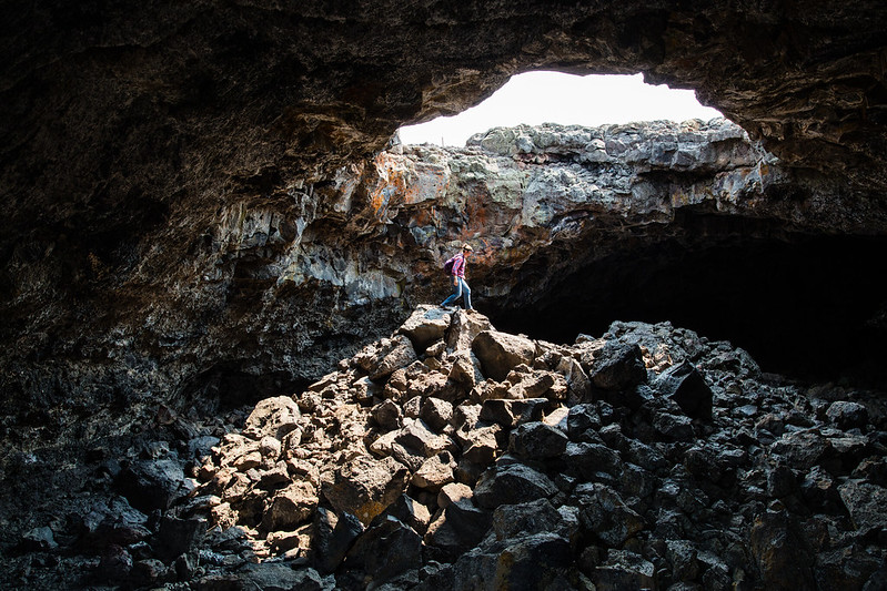
At the end of the Loop Road, the Caves Area trail leads to lava tubes. These tunnels formed when the outside of a lava river cooled into a crust while hot lava kept flowing inside, then drained away. Indian Tunnel is the big one, with skylights where the roof has collapsed, so you can see without a light in much of it. Dewdrop Cave is smaller.
You need a free cave permit, issued only in person at the visitor center during business hours. Your park pass doesn’t count. The permit process includes a few questions to protect the park’s bats from white-nose syndrome, so don’t wear clothes or shoes that have been in other caves. Bring a flashlight or headlamp, sturdy shoes and gloves. Several other caves are closed to protect bats.
Love caves? Our guide to Lehman Caves in Great Basin National Park covers a very different kind of cave in neighboring Nevada.
Sample Craters of the Moon Itineraries
Quick stop: 1 to 2 hours
| Time | Plan |
|---|---|
| 0:00 | Visitor center: map, water, restrooms |
| 0:15 | North Crater Flow (short walk) |
| 0:35 | Inferno Cone climb |
| 1:15 | Spatter Cones and Big Craters |
| 1:45 | Finish the Loop Road and head back to the highway |
Half day: 3 to 4 hours
Start at the visitor center and get your cave permit first. Walk North Crater Flow and Devils Orchard, climb Inferno Cone, then visit the Spatter Cones. Finish at the Caves Area and explore Indian Tunnel. In summer, do Inferno Cone first thing while it’s cool, then save the shady caves for the hot afternoon.
Full day
Add the Broken Top Loop or Tree Molds Trail, have a picnic, and stay for sunset from Inferno Cone. If you’re camping, wait for dark and enjoy some of the best stargazing in Idaho.
Where to Stay Near Inferno Cone
- Lava Flow Campground: inside the park, near the visitor center, with first-come, first-served sites tucked among the lava. It reopened in 2025 after a major rebuild. $15 a night in summer, or $8 in the early and late season when there’s no water. Pay by card at the machine. No reservations.
- Arco: the closest town, about 20 minutes east, with a few motels, diners and gas. Arco was the first town in the world lit by nuclear power, in 1955.
- Carey: a tiny town about 25 minutes west, with very limited services.
- Sun Valley and Ketchum: about 1.5 hours away, with resort hotels and the best restaurants in the region.
- Idaho Falls: about 1.5 hours east. The biggest choice of chain hotels, and handy if you’re coming from Yellowstone.
Is the Inferno Cone Trail Worth It?
Yes. It’s the most rewarding 30 minutes you can spend at Craters of the Moon. In one short, steep climb, you get a view that explains the whole park: the lava fields, the line of volcanoes along the Great Rift and the mountains around it. It’s also just fun. How often do you get to walk up a volcano?
To be honest about the downsides: it’s brutal on a hot summer afternoon, unpleasant in strong wind, and there’s no crater on top if that’s what you were picturing. Time it well, and none of that matters.
Inferno Cone Trail FAQs
How long is the Inferno Cone Trail?
It’s 0.4 mile round trip, with 164 feet of elevation gain, from the parking lot to the summit and back.
How long does it take to hike Inferno Cone?
The Park Service suggests 30 to 45 minutes. The climb itself takes most people 5 to 15 minutes.
Is the Inferno Cone Trail hard?
It’s short but very steep. The park rates it moderate. Most healthy people, including kids, can do it by taking their time.
How tall is Inferno Cone?
The summit is about 6,181 feet above sea level. The trail climbs 164 feet from the parking lot to the top.
Can you see the Tetons from Inferno Cone?
On the clearest days, yes. They’re about 100 miles to the east. Haze and wildfire smoke often hide them in summer.
Does Inferno Cone have a crater?
No. Strong winds blew the falling cinders to one side of the vent during the eruption, so it built a broad mound instead of a cone with a crater. You can see craters at Big Craters, nearby on the Loop Road.
Do you need a permit to hike Inferno Cone?
No. You only pay the park entrance fee of $20 per vehicle. Cave permits are only needed for the lava tubes.
Are dogs allowed on the Inferno Cone Trail?
No. Pets aren’t allowed on any trails or in caves at Craters of the Moon. They can go on paved roads, in parking areas and in the campground on a leash.
Is Inferno Cone open in winter?
The Loop Road closes to cars from about mid-November to mid-April. You can still ski or snowshoe about 2.5 miles each way from the visitor center to reach it.
When did Inferno Cone last erupt?
The cinders on Inferno Cone are roughly 2,400 years old. The most recent eruptions in the park happened about 2,000 years ago, and more eruptions are expected someday.
What is the best time to hike Inferno Cone?
May to early June and September to October, early in the morning. Avoid hot summer afternoons and very windy days.
Final Thoughts
Inferno Cone proves a hike doesn’t have to be long to be memorable. In a quarter mile, you climb a pile of glittering black cinders and end up on top of a volcanic landscape that looks more like the Moon than Idaho.
Go early, wear shoes with grip, check the wind, and take your time on the way down. Then stand on the summit, follow the line of volcanoes across the plain, and try to imagine the ground here glowing red.