

Trail update (October 2026): The Park Service listed Warner Point Trail as open in its October 13, 2026 conditions report, with a note that it can be wet and muddy after rain or snow. South Rim Road usually stays open to High Point until the first big snowfall, often around mid-November, and then closes to cars beyond the visitor center for the winter. If you’re visiting late in the fall, check the park’s current conditions page the day before you go.
Most people see Black Canyon of the Gunnison from the railings of a roadside overlook. They look down, say “wow,” and drive on to the next one. That’s fine, but you miss something. Drive to the very end of South Rim Drive, walk 0.8 mile through old pinyon and juniper trees, and you’ll stand at Warner Point, where the canyon is about 2,700 feet deep. On one side the cliffs drop almost straight to the Gunnison River. On the other, you can see across the Uncompahgre Valley to the snowy San Juan Mountains.
The Warner Point Trail is short, but it’s the one hike on the South Rim that gives you canyon views and mountain views on the same walk. This guide covers everything you need: distance, how hard it really is, the trail map, parking at High Point, fees, the best season and time of day, what you’ll see, and the important difference between this easy nature trail and the very hard Warner Route that drops into the canyon.
Cover photo: the view from Warner Point Trail. Photo: NPS / de Anguera
Warner Point Trail: Quick Facts
| Detail | Information |
|---|---|
| Location | South Rim, Black Canyon of the Gunnison National Park, Colorado |
| Trailhead | High Point parking area, at the end of South Rim Drive |
| Distance | 0.8 mile one way, about 1.6 miles round trip |
| Elevation change | About 200 feet (GPS tracks show around 300 feet of total ups and downs) |
| Highest point | About 8,300 feet at Warner Point |
| Time | 45 to 75 minutes for most people |
| Difficulty | Easy to moderate (the Park Service calls it “moderate strenuous”) |
| Trail type | Out and back, unpaved, some short steep sections |
| Canyon depth at the end | About 2,700 feet, the deepest view in the park |
| Permit | None needed for this trail |
| Entrance fee | $30 per vehicle, good for 7 days (cashless) |
| Dogs | Not allowed |
| Wheelchair accessible | No |
| Restroom | Vault toilet at the High Point trailhead |
| Water | None at the trailhead, so bring your own |
| Best time | Late May to mid-October; early morning or late afternoon |
How Long Is the Warner Point Trail?
The Warner Point Trail is 0.8 mile one way, or about 1.6 miles round trip. You walk from High Point to Warner Point and come back the same way. Most people take 45 minutes to an hour and 15 minutes, including time at the viewpoint.
You’ll see slightly different numbers online. Some apps say 1.5 miles, others 1.6. The Park Service says 0.8 mile each way. The difference is just how much wandering you do around the viewpoint. For elevation, the Park Service lists about 200 feet. GPS tracks often show closer to 300 feet, because they add up every small dip and rise. Either way, it’s a short walk.
| Type of visitor | Round-trip time (rough guide) |
|---|---|
| Fast hiker | 35 to 50 minutes |
| Average visitor | 45 to 75 minutes |
| Photographer | 60 to 90 minutes |
| Family with young kids | 60 to 90 minutes or more |
Where Is the Warner Point Trail?
The trail is on the South Rim of Black Canyon of the Gunnison National Park, in western Colorado. It starts at High Point, the last stop at the far western end of South Rim Drive.
The park has two rims, and they are not connected by a bridge. Driving from one to the other takes about two hours. The South Rim is the busier side, with the visitor center, a paved scenic road and 12 overlooks. Warner Point is only on the South Rim, so make sure your GPS is taking you there.
How to get there
- From Montrose: drive east on US-50 for about 8 miles, then turn left (north) onto Colorado Highway 347. Follow it about 5 miles to the park entrance. Montrose to the entrance takes about 20 minutes.
- Pay at the entrance station (card or digital pass only; the park is cashless).
- Stop at the South Rim Visitor Center for maps, restrooms and drinking water. This is your last reliable water stop.
- Drive South Rim Drive about 7 miles to the end of the road. It’s paved and fine for any car.
- Park at High Point. The trail starts at the west end of the lot.
Driving times to the park: about 1.5 hours from Grand Junction, about 1.5 hours from Gunnison, about an hour from Ouray via Montrose, and around 5 to 5.5 hours from Denver. Montrose Regional Airport is the closest airport, about 25 minutes from the entrance.
Tip: Cell service on the rim is patchy. Download an offline map and a screenshot of this guide before you leave Montrose.
At the High Point Trailhead
High Point is the last of the 12 overlooks on South Rim Drive. You’ll find a parking lot, a vault toilet and a picnic table. The parking lot is small. On summer afternoons it can fill, but cars come and go quickly, so you rarely wait long.
Look for the trail sign and a box with printed trail guides. Grab one. It matches numbered posts along the path and explains the plants, birds and geology you’re walking past. The same guide is often available at the visitor center. Please return it at the end if you don’t plan to keep it.
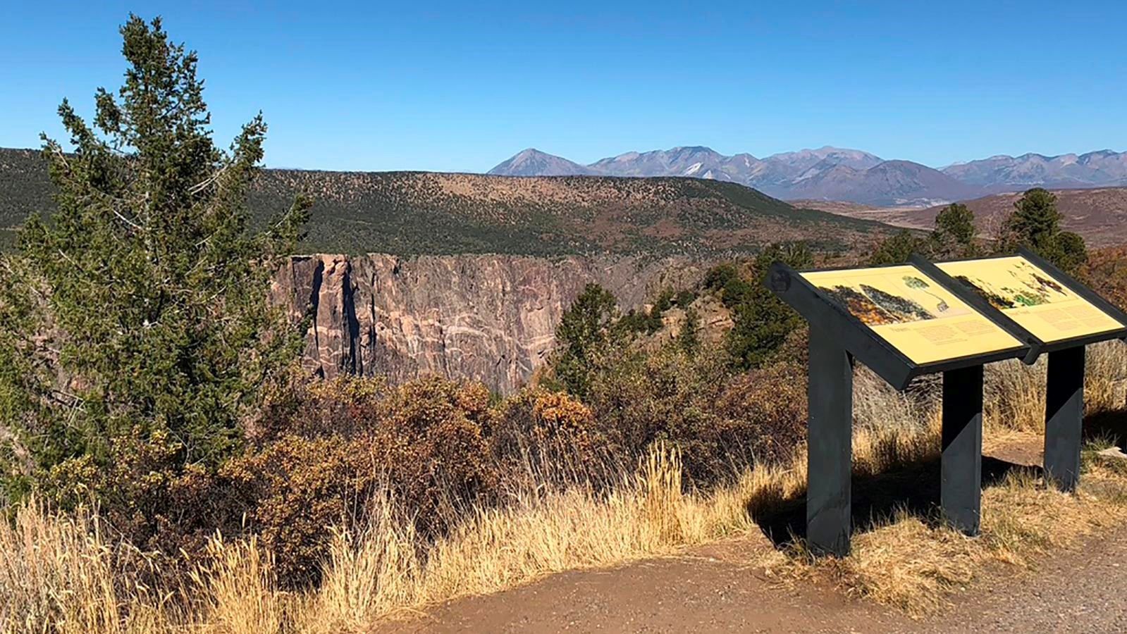
The High Point “overlook” itself is a short walk down the start of the trail. Funny enough, it doesn’t look into the canyon. It looks south over Montrose and the Uncompahgre Valley. The canyon view is waiting at the other end of the trail.
Warner Point Trail Map and Route
The route is simple, and you won’t get lost if you stay on the main path:
High Point parking lot → gentle drop to a saddle on the ridge → short climb through pinyon and juniper → small sign pointing to Warner Point → flat-topped summit and overlook (about 8,300 feet) → back the same way
The trail follows a narrow ridge heading west. The canyon is to your right (north), and the valley is to your left (south). There are no big switchbacks and no scrambling. The path is dirt and crushed granite, with roots and rocks in places.
Section 1: High Point to the saddle
The trail starts by dropping gently away from the parking lot. You’re walking through a pygmy forest of short, twisted pinyon pines and Utah junipers, mixed with mountain mahogany, serviceberry and Gambel oak. These trees grow slowly in the thin, rocky soil, and some of the gnarled junipers up here are centuries old. On a warm day, the air smells like pine and sage.
Section 2: Benches and big mountain views
After the saddle, the trail climbs a little and starts to open up. This is where you get the “other” view that makes Warner Point special. Look south and you’ll see the green farm fields of the Uncompahgre Valley, the open meadows of Bostwick Park, and on clear days, the jagged peaks of the San Juan Mountains on the horizon. Look north and the West Elk Mountains rise beyond the canyon.
There are shaded benches along this part of the trail. Use them. You’re at about 8,200 feet, and if you drove in from a lower elevation, you’ll probably feel it.
Section 3: The final climb to Warner Point
The last part is the steepest. It’s a short uphill on loose, gravelly ground, which can be slippery on the way back down. Near the end, you’ll see a small sign pointing to Warner Point. Stay on the main, maintained trail. An unmarked path drops off near here. That’s the start of the Warner Route into the inner canyon, which needs a permit and is a completely different hike (more on that below).
Section 4: The Warner Point overlook
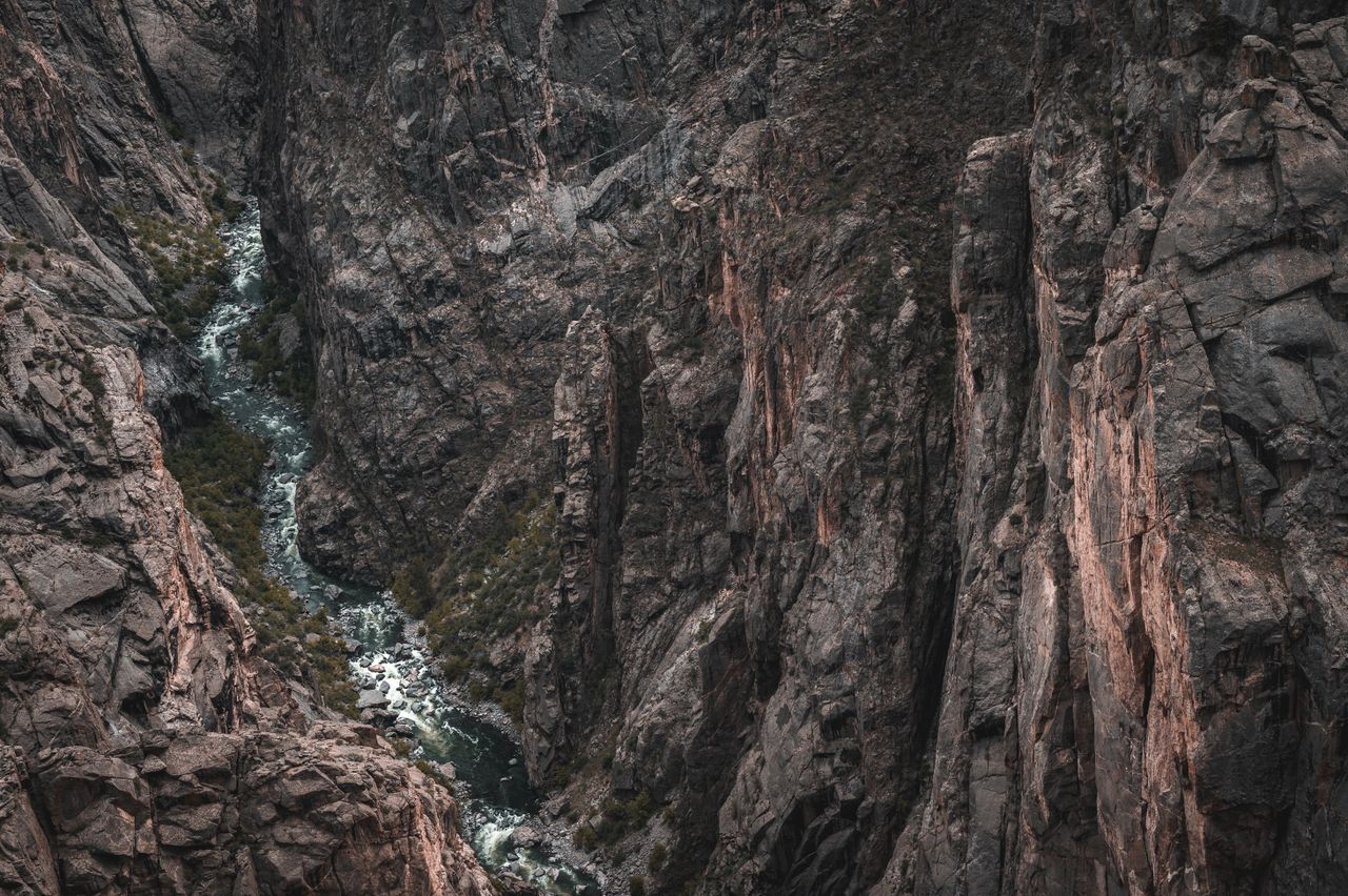
The trail ends on a small, flat summit with a view straight into the Black Canyon. Here the walls drop about 2,700 feet to the Gunnison River. That’s the deepest view you can get in the park. You can see the river far below and follow it as the canyon slowly opens up to the west. On a quiet day you might hear it, too.
There’s no railing at the end. The rock ledges are steep, and the ground is loose in places. Find a safe spot well back from the edge, sit down and enjoy it. When you’re ready, head back the way you came.

How Hard Is the Warner Point Trail?
For most people, the Warner Point Trail is an easy to moderate walk. It’s short and mostly gentle, but it has a few steep, loose sections and it’s at high elevation. The Park Service rates it “moderate strenuous,” mostly because of those steep spots and the altitude. Many hiking sites call it easy. The truth is somewhere in between.
What makes it harder than it looks:
- Altitude. The whole trail is above 8,100 feet. If you live near sea level, you’ll breathe harder and tire faster.
- Loose gravel. The crushed granite surface can feel like walking on tiny ball bearings, especially downhill near the end.
- Ups and downs. You lose a little height at the start, so the walk back to the car ends with a short climb.
- Sun. Some sections are open, and the sun is strong at this elevation.
Is it good for beginners?
Yes. If you can walk a mile and a half on a dirt path with a few hills, you can do this hike. Wear shoes with good grip, carry water and take it slow. If you’re new to hiking, our hiking for beginners guide covers what to wear and bring.
Is it good for kids?
Mostly, yes. Kids who are used to walking a mile or two usually enjoy it, and the numbered posts and trail guide turn it into a little scavenger hunt. The big concern is the end. The overlook has no railing and a very long drop, so keep young children close and holding hands at the viewpoint. Toddlers are safer in a carrier. Strollers won’t work on this trail.
Can you bring a dog?
No. Pets aren’t allowed on the Warner Point Trail. On the South Rim, leashed dogs are allowed on the Rim Rock Trail, the Cedar Point Nature Trail and the campground roads, plus overlooks along the road. Only trained service animals can go on Warner Point.
What You’ll See From Warner Point
| Look… | What you’ll see |
|---|---|
| Down (north side of the trail) | The Black Canyon and the Gunnison River, about 2,700 feet below |
| South | The Uncompahgre Valley, Bostwick Park, the town of Montrose, and the San Juan Mountains on the horizon |
| North | The West Elk Mountains beyond the canyon |
| West | The canyon slowly opening up as the river heads toward the plains |
| Around you | Old pinyon pines, junipers, mountain mahogany and serviceberry |
The deepest view in the park
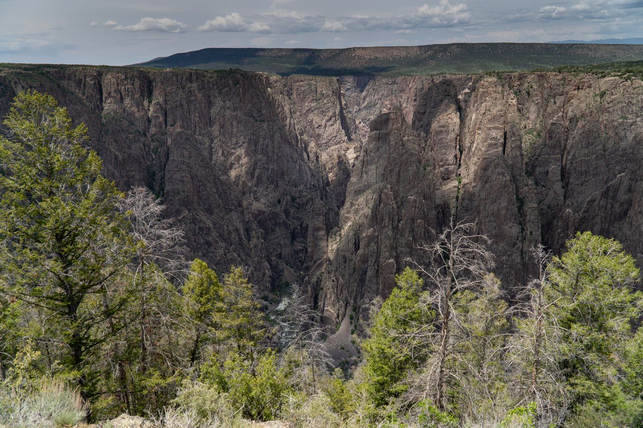
Black Canyon gets its name because some parts are so deep and narrow that sunlight only reaches the bottom for a short time each day. The walls are mostly ancient, dark gray gneiss and schist, some of the oldest rock in North America, close to 1.7 billion years old. Warner Point sits above the deepest part of the canyon. The Warner Route, which starts near the overlook, drops 2,722 feet to the river. That’s the full height of the wall you’re looking down.
The Gunnison River
It’s hard to believe the thin ribbon of water below carved all of this. The Gunnison River cut down through the hard rock over about two million years. It drops faster here than most rivers in North America, which is part of the reason the canyon is so steep. From Warner Point you can usually see sections of the river, and on calm days you can hear it.
Wildlife to watch for
Keep an eye out for mule deer in the trees, ravens riding the wind over the canyon, and white-throated swifts zipping past the cliffs. Peregrine falcons nest on the canyon walls in spring and summer. You’ll probably see chipmunks and ground squirrels near the benches. Black bears live in the park too, though you’re unlikely to see one on this busy little trail. If you do, give it plenty of space.
Who was Warner?
The trail is named after Mark Warner, a Presbyterian minister in Montrose who moved to western Colorado in 1917. He spent years pushing for the canyon to be protected, and that work helped lead to Black Canyon becoming a national monument in 1933. It became a national park in 1999, and the point at the end of this trail still carries his name.
Warner Point Trail vs. Warner Route: Don’t Mix Them Up
This is the most important thing in this guide. The names sound almost the same, but they’re two completely different hikes.
| Warner Point Trail (nature trail) | Warner Route (wilderness route) | |
|---|---|---|
| Where it goes | Along the rim to a canyon overlook | Down into the canyon to the Gunnison River |
| Distance | 0.8 mile one way | 2.75 miles one way |
| Elevation change | About 200 feet | 2,722 feet down, then back up |
| Time | About 1 hour round trip | 2 to 2.5 hours down, about 4 hours up; often done overnight |
| Trail | Maintained, signed path | Unmarked, steep, loose rock and scrambling |
| Permit | Not needed | Wilderness permit required, even for a day trip |
| Who it’s for | Almost everyone | Very fit, experienced canyon hikers only |
The Warner Route is the longest of the South Rim’s wilderness routes. It leaves the nature trail near its end, crosses a saddle and then plunges down a steep gully to the river. There are five campsites at the bottom, and up to three nights are allowed per permit. The climb back out is brutal, with very little shade.
If you’re thinking about the Warner Route:
- Get a permit on Recreation.gov. In 2026, booking opened April 1 for May to July trips and July 1 for August to October trips. Wilderness permits cost $6 plus $4 per person, on top of the park entrance fee.
- Watch the park’s orientation videos for wilderness routes and the Warner Route before you go.
- Expect poison ivy near the river. It can grow about 5 feet tall and is hard to avoid.
- Carry a lot of water, up to 4 liters per person per day, plus a filter. The canyon bottom can be 5 to 10 degrees hotter than the rim.
- Bring a bear-proof food container if you’re camping. Black bears live in the canyon.
- Be ready to rescue yourself. Help can take many hours, or longer, to reach you.
If you just want a great view and a nice walk, stick to the nature trail. You’ll see the same canyon without the 2,700-foot climb out.
Best Time to Hike Warner Point Trail
The best time to hike Warner Point Trail is from late May through mid-October, when South Rim Drive is open all the way to High Point and the trail is usually dry. September and early October are our favorite months: cooler air, clear skies and fewer people.
| Season | What it’s like | Our take |
|---|---|---|
| Spring (April–May) | The road to High Point usually opens in late April. Snow and mud can linger on the trail into May. | Good by late May. Check conditions first. |
| Summer (June–August) | Warm days, but cooler than Montrose because of the elevation. Afternoon thunderstorms are common in July and August. | Great if you hike in the morning. |
| Fall (September–October) | Crisp mornings, clear air, fewer crowds. Gambel oak and serviceberry turn orange and red. | The best time. |
| Winter (November–March) | South Rim Road closes to cars beyond the visitor center after the first big snow. | Only for skiers and snowshoers (see below). |
Can you hike Warner Point in winter?
Yes, but not by car. In winter, cars can only drive as far as the visitor center. The closed road beyond it becomes a ski and snowshoe trail, groomed when there’s enough snow. Getting to High Point and back is about 12 miles round trip before you even start the Warner Point Trail. It’s a beautiful, quiet day out for strong skiers and snowshoers, but it’s a full-day trip. The park sometimes offers free ranger-led snowshoe walks near the visitor center when snow is deep, usually in January.
Best time of day
- Morning: the coolest temperatures, the calmest air and the best chance of having the trail to yourself. In summer, it’s also your best bet for avoiding afternoon storms.
- Late afternoon and sunset: warm light on the valley and the San Juans, and long shadows in the canyon. Warner Point and nearby Sunset View are two of the best sunset spots on the South Rim. Bring a headlamp so you’re not walking back on loose gravel in the dark.
- Midday: fine in spring and fall, but the light is flat for photos and the canyon floor sits in deep shadow.
Entrance Fees, Permits and Hours
- Private vehicle: $30, good for 7 days.
- Motorcycle: $25, good for 7 days.
- On foot or bicycle: $15 per person, good for 7 days. Kids under 16 are free.
- Black Canyon annual pass: $55. The America the Beautiful pass also covers your entry.
- Cashless only: pay by card at the entrance, or buy a digital pass on Recreation.gov ahead of time.
- Free entrance days left in 2026: October 27 and November 11 (Veterans Day), for US citizens and residents.
- No permit or reservation is needed for the Warner Point Trail.
Hours: The park is open 24 hours a day, all year. South Rim Road to High Point is usually open to cars from late April to mid-November. The South Rim Visitor Center is open daily, with shorter hours from fall to spring. If you want to talk to a ranger first, call the park at 970-641-2337.
Safety Tips for Warner Point
- Stay back from the edge. There’s no railing at Warner Point, and the cliffs drop thousands of feet. Never step past the end of the trail for a photo.
- Watch the sky in summer. Afternoon thunderstorms build fast over the rim, and an exposed point is a bad place to be in lightning. If you hear thunder, head back to your car.
- Take the altitude seriously. Drink water, go slowly and rest on the benches. Headache, dizziness or nausea mean it’s time to turn around.
- Mind your footing. The loose gravel near the end is slippery, especially going downhill.
- Don’t throw anything into the canyon. Climbers and hikers may be below you.
- Stay on the marked trail. The fragile soil crust and old trees are easily damaged.
What to Bring
| Item | Why |
|---|---|
| Water (at least 1 liter per person) | There’s no water at High Point. Fill up at the visitor center. |
| Shoes with good grip | Loose gravel near the end. Sneakers are fine; sandals aren’t great. |
| Sun hat, sunglasses, sunscreen | The sun is strong above 8,000 feet |
| Light jacket | It’s often windy and cool at the overlook, even in summer |
| Rain jacket (July–August) | Afternoon storms |
| Camera or phone | The views are worth it |
| Snacks | There’s no food on the South Rim except small snacks at the visitor center |
| Headlamp | If you’re staying for sunset |
| Binoculars | For spotting the river, birds and distant peaks |
A light shell is handy at this elevation. Our best waterproof hiking jacket guide covers packable options, and if your knees don’t love loose downhills, a pair of budget trekking poles helps.
Photography Tips
- Shoot both directions. Most people only photograph the canyon. The valley and San Juans to the south are just as good, especially in late light.
- Use the trees as a frame. A twisted juniper in the foreground with the canyon behind it gives your photo depth and scale.
- Bring a zoom. A longer lens helps you pick out the river far below and the distant peaks.
- Watch the contrast. The bright rim and dark canyon are hard for cameras. Shoot early or late, or use your phone’s HDR mode.
- Stay for the stars. Black Canyon is an International Dark Sky Park, and the far end of South Rim Drive is one of the darkest spots on the rim.
Other Stops on South Rim Drive
You have to drive the whole of South Rim Drive to reach Warner Point, so it’s worth stopping at a few overlooks along the way. Here they are in order, from the visitor center to the end of the road, with the one-way walk from the parking area.
| # | Overlook | Walk (one way) | Why stop |
|---|---|---|---|
| 1 | Tomichi Point | A few steps | First look into the canyon |
| 2 | Gunnison Point | About 100 yards | Right behind the visitor center |
| 3 | Pulpit Rock | About 130 yards | Long view up the canyon |
| 4 | Cross Fissures View | About 350 yards | Deep cracks in the canyon wall |
| 5 | Rock Point | About 300 yards | Quieter, fewer people |
| 6 | Devils Lookout | About 600 yards | Dramatic view from a rocky point |
| 7 | Chasm View | About 100 yards | The canyon’s narrowest, steepest walls |
| 8 | Painted Wall View | About 200 yards | Colorado’s tallest cliff (a must) |
| 9 | Cedar Point Nature Trail | About 300 yards | Great Painted Wall view, signs about plants |
| 10 | Dragon Point | About 100 yards | Another angle on the Painted Wall |
| 11 | Sunset View | A few steps | Picnic tables and a great sunset spot |
| 12 | High Point | About 100 yards | Trailhead for Warner Point |
Painted Wall View
If you only stop at one other overlook, make it this one. The Painted Wall rises 2,250 feet from the river to the rim, making it the tallest cliff in Colorado. Pale pink and white stripes of rock run across its dark face like streaks of paint. These stripes formed when hot, liquid rock squeezed into cracks deep underground, long before the canyon was carved.

Chasm View
At Chasm View, the canyon is at its narrowest. The two rims are only about 1,100 feet apart, and the walls look like they’re about to touch. It’s the best place to understand why this canyon feels so different from the Grand Canyon.

Other short South Rim trails
- Cedar Point Nature Trail: about 0.7 mile round trip, easy, with two overlooks facing the Painted Wall.
- Oak Flat Loop: about 2 miles from the visitor center, and the only South Rim trail that dips below the rim. It’s steeper than Warner Point.
- Rim Rock Trail: about 1 mile round trip from the campground to Tomichi Point. Parts of it pass through the area burned in the 2025 South Rim Fire.
Half-Day South Rim Plan With Warner Point
| Time | Plan |
|---|---|
| 8:00 a.m. | Leave Montrose with water and snacks |
| 8:30 a.m. | Visitor center: restrooms, water, Gunnison Point overlook |
| 9:00 a.m. | Drive straight to High Point while it’s cool and quiet |
| 9:15 a.m. | Hike the Warner Point Trail |
| 10:30 a.m. | Drive back east: Sunset View, Painted Wall View, Chasm View |
| 11:30 a.m. | Pulpit Rock and Tomichi Point |
| 12:30 p.m. | Lunch back in Montrose |
Why go to the end first? Warner Point is the only real hike in this plan, so do it while it’s cool and before afternoon storms. You’ll pass all the other overlooks on your way back anyway. If you’d rather catch sunset, simply flip the plan: overlooks in the afternoon, then Warner Point in the last two hours of daylight.
Where to Stay Near Warner Point
- South Rim Campground: inside the park, about 15 minutes’ drive from High Point. Much of it burned in the 2025 South Rim Fire. As of October 2026, 25 non-electric sites have reopened ($20 a night, reservations on Recreation.gov). Expect some ash and fire debris, and bring your own water when the water is turned off for the season.
- Montrose: the best base, about 20 to 30 minutes from the park, with the most hotels, restaurants and grocery stores.
- North Rim and East Portal campgrounds: small, first-come, first-served campgrounds elsewhere in the park ($20 a night). The North Rim is a long drive from the South Rim.
- Gunnison: about 1.5 hours east. Handy if you’re also visiting Curecanti National Recreation Area or Crested Butte.
- Ouray or Ridgway: about 30 to 45 minutes south of Montrose. Great if you’re combining Black Canyon with the San Juan Mountains.
Is the Warner Point Trail Worth It?
Yes. If you have one extra hour on the South Rim, this is the best way to spend it. It’s the only short walk in the park that shows you the canyon’s deepest view and the big mountain and valley views together. And because it sits at the very end of the road, it’s usually quieter than overlooks like Painted Wall.
To be fair: if you only want the most dramatic canyon views, Chasm View and Painted Wall give you those with a 2-minute walk. And if loose gravel and a few hills are a problem, stick to the roadside overlooks. But for most visitors, Warner Point is the walk you’ll remember.
Warner Point Trail FAQs
How long is Warner Point Trail in Black Canyon?
It’s 0.8 mile one way, about 1.6 miles round trip, from High Point at the end of South Rim Drive to Warner Point.
How long does it take to hike Warner Point Trail?
Most people take 45 to 75 minutes round trip, including time at the overlook. Photographers and families often take up to an hour and a half.
How hard is Warner Point Trail?
It’s easy to moderate. It’s short with about 200 feet of elevation change, but it has a few steep, loose sections and sits above 8,000 feet. The Park Service rates it “moderate strenuous.”
Where does the Warner Point Trail start?
At the High Point parking area, the last overlook at the end of South Rim Drive, about 7 miles past the South Rim Visitor Center.
How deep is the canyon at Warner Point?
About 2,700 feet. The Warner Route, which drops from near the overlook to the river, loses 2,722 feet. That’s the deepest view in the park.
Do you need a permit for Warner Point Trail?
No. You only pay the park entrance fee. The separate Warner Route into the inner canyon needs a wilderness permit from Recreation.gov.
Can you see the Gunnison River from Warner Point?
Yes. From the overlook at the end of the trail, you can look straight down to the river, about 2,700 feet below.
Are dogs allowed on Warner Point Trail?
No. Pets aren’t allowed. Leashed dogs can use the Rim Rock Trail, the Cedar Point Nature Trail and roadside overlooks on the South Rim.
Is Warner Point Trail open in winter?
The trail is, but the road isn’t. After the first big snow, South Rim Road closes to cars beyond the visitor center. You can ski or snowshoe to High Point, about 12 miles round trip.
Is Warner Point good for sunset?
Yes. It’s one of the best sunset spots on the South Rim, with warm light on the valley and mountains. Bring a headlamp for the walk back.
Is Warner Point Trail wheelchair accessible?
No. It’s unpaved and steep in places. For accessible views, try Tomichi Point, Sunset View or the overlooks right beside South Rim Drive.
Final Thoughts
Warner Point is proof that a short trail can still feel like a real hike. In less than an hour, you walk through old pinyon and juniper woods, look out over farms and snowy peaks, and then stand above the deepest part of one of the steepest canyons in North America.
Drive to the end of the road, grab a trail guide at High Point, take your time on the benches, and stay well back from that edge. Just don’t confuse it with the Warner Route, unless you’ve got a permit and very strong legs.