
It’s only a little over a mile to the top. That’s what fools people.
The Camelback Mountain Echo Canyon Trail is the most famous hike in Phoenix, and one of the toughest short hikes in Arizona. In just 1.14 miles, you climb about 1,400 feet up steep rock, pull yourself up sections with metal handrails, and scramble over big boulders near the summit. The city officially rates it Extremely Difficult.
The reward? A 360-degree view over Phoenix, Scottsdale, Paradise Valley and the desert mountains all around, from the 2,704-foot summit of the city’s most iconic peak.
This guide explains everything in simple words: the real difficulty, parking (the hardest part for many people), trail hours, sunrise hikes, heat closures, what each section feels like, and how to get up and down safely.
Quick answer
- Distance: 1.14 miles one way, about 2.3 miles round trip (City of Phoenix).
- Elevation gain: about 1,400 feet.
- Summit: 2,704 feet.
- Time: about 2 to 3 hours round trip for most people.
- Difficulty: Extremely Difficult (official rating). Handrails and scrambling.
- Hours: sunrise to sunset.
- Trailhead: 4925 E. McDonald Dr., Phoenix, AZ 85018.
- Parking: small lot that fills fast. Gate closes when full.
- Dogs: not allowed, ever.
- Heat: closed 8 a.m.–5 p.m. on Extreme Heat Warning days.
Echo Canyon Trail at a Glance
| Location | Camelback Mountain, Phoenix, Arizona |
| Trailhead address | 4925 E. McDonald Drive, Phoenix, AZ 85018 |
| Distance | 1.14 miles one way (about 2.3 miles round trip) |
| Elevation change | About 1,400 feet |
| Summit elevation | 2,704 feet |
| Difficulty | Extremely Difficult |
| Time | About 2–3 hours round trip |
| Hours | Sunrise to sunset |
| Facilities | Restrooms, drinking water, benches, small shade canopy |
| Dogs | Prohibited on all Camelback trails, year-round |
| Best season | November to March |
| Gatehouse phone | 602-534-5867 |
Facts above are from the City of Phoenix. Some hiking apps round the distance to 2.4–2.5 miles.
Note: this guide is about Echo Canyon on Camelback Mountain in Phoenix. Looking for the Echo Canyon in southeast Arizona? See our Echo Canyon Loop Trail in Chiricahua.
Where Is Camelback Mountain?
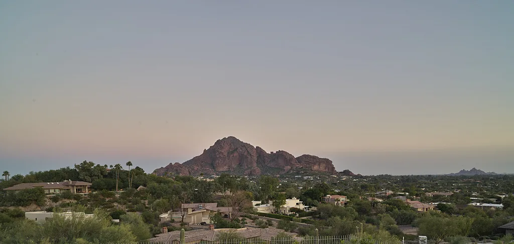
Camelback Mountain sits right in the middle of the Phoenix metro area, between Phoenix, Paradise Valley and Scottsdale. You can see it from all over the valley. Its shape looks like a kneeling camel, with a “head” on the west end and a big “hump” (the summit) to the east.
The Echo Canyon Trailhead is on the north side of the mountain, on East McDonald Drive. Even though many people search for “Camelback Mountain Scottsdale,” the trailhead address is in Phoenix.
How to get to Echo Canyon Trailhead
Put 4925 E. McDonald Drive, Phoenix, AZ 85018 into your map app. The entrance is near the corner of McDonald Drive and Tatum Boulevard, through a residential area. Drive slowly and follow the signs.
Echo Canyon Parking: Read This First
Parking is the number-one headache at Camelback. The lot is small compared to how many people want to hike.
- In winter and spring, the City of Phoenix says the lot is usually full from late morning to early afternoon on weekdays, and all day on weekends.
- When the lot is full, the entry gate closes.
- You can’t wait or idle on McDonald Drive or Tatum Boulevard. Police ticket drivers who do, and illegally parked cars get towed.
- Neighborhood streets around the mountain have strict no-parking rules.
Tips to get a spot
- Arrive right at sunrise, especially on weekends.
- Try a weekday.
- Use a rideshare (Uber or Lyft) to get dropped off, so you don’t need parking at all.
- If the gate is closed, leave and come back later. Don’t circle or wait on the road.
The trailhead has restrooms, drinking water, benches and a small shade structure. Fill your bottles before you start; there’s no water on the trail.
How Long Is the Echo Canyon Trail?
The City of Phoenix lists the trail as 1.14 miles one way, so about 2.3 miles round trip. That sounds like nothing. But you climb about 1,400 feet in that short distance, which makes it one of the steepest trails in the city.
| Option | Distance | Time | Who it’s for |
|---|---|---|---|
| Bobby’s Rock Loop | 0.2 mi loop | 15–30 min | Anyone wanting a taste |
| To the first handrails and back | About 1 mi | 45–60 min | Fit hikers testing the trail |
| Summit and back | About 2.3 mi | 2–3 hrs | Experienced, fit hikers |
Fast, fit locals sometimes do it in about an hour. First-timers should plan 2–3 hours, plus time for photos at the top.
How Hard Is the Echo Canyon Trail?
The city rates it Extremely Difficult, and it means it. The trail is very steep, rocky and fully exposed, with little shade and few flat spots to rest. Some sections need handrails, and parts near the top need actual climbing with your hands. The trail also gets less defined near the summit.
The city notes that rescue crews have helped even experienced hikers here. It recommends that only experienced hikers try the summit, in good weather.
Is it good for beginners?
No. If you’re new to hiking, start with an easier Phoenix trail and build up. Bobby’s Rock Loop at the same trailhead is a good way to see the area without the summit climb. Our hiking for beginners guide has tips to get started.
Do you need climbing experience?
You don’t need ropes or climbing gear. But you do need to be comfortable using your hands to pull yourself up big rock steps, and okay with some height and exposure. If a section makes you nervous going up, remember it’ll feel scarier coming down.
What to Expect on the Echo Canyon Trail
1. The lower trail and Bobby’s Rock
The trail starts climbing almost right away from the trailhead. Soon you’ll pass Bobby’s Rock, a big cube-shaped sandstone boulder. A short side loop goes around it.
The early views look out over Paradise Valley and the Phoenix Mountains Preserve. You’ll see saguaros, creosote and teddy bear chollas. (Don’t touch the chollas. Seriously.)
2. The handrail sections
This is where Echo Canyon gets serious. The trail goes up steep, smooth rock slopes with metal handrails. You’ll grab the rail, lean in, and step up carefully. Rubber soles with good grip make a big difference here.
These sections get crowded. Be patient, let faster people pass at wide spots, and don’t crowd anyone on the steep parts.
3. The boulder field
After a short, easier stretch, the upper trail turns into a jumble of big boulders and rock steps. It’s steep and uneven, and you’ll use your hands a lot. The route isn’t always obvious. Look for the worn path and follow other hikers’ lines.
This part tires people out. Take breaks. The summit is closer than it looks, but rushing leads to falls.
4. The summit
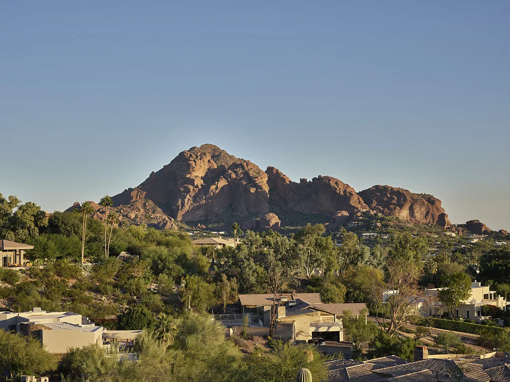
At 2,704 feet, the top is a wide, rocky area with views in every direction: downtown Phoenix, Scottsdale, Paradise Valley, Piestewa Peak, the McDowell Mountains, and on clear days, the Superstition Mountains far to the east. Find a safe spot, drink water, eat a snack and soak it in.
5. Coming down
Many hikers say the descent is harder than the climb. Your legs are tired, the rock is smooth, and you’re looking down the whole time. Go slowly, use the handrails, keep your weight over your feet, and use your hands (or sit and scoot) on big steps. Tired legs on the way down are when slips are most likely.
Can You Hike Camelback at Sunrise?
Yes, but the trailhead opens at sunrise, not before. You can’t start in the dark. So you won’t be on the summit for the exact moment of sunrise, but starting at opening time gives you:
- The coolest temperatures of the day.
- Your best chance at a parking spot.
- Soft morning light over the valley.
Plan to be off the mountain before sunset, when the trailhead closes.
Best Time to Hike Echo Canyon
| Season | Conditions | Verdict |
|---|---|---|
| November–February | Cool, mostly sunny | Best time (but busiest) |
| March–April | Warm, crowded | Good, start at sunrise |
| October | Still hot | Early morning only |
| May–September | Extreme heat and monsoon storms | Avoid |
Heat closures
Under Phoenix’s Trail Heat Safety Program, the Echo Canyon Trail closes from 8 a.m. to 5 p.m. on days when the National Weather Service issues an Extreme Heat Warning. Even when it’s open, summer heat on this shadeless rock is dangerous. Check the city’s heat safety page before you go.
Rain and wind
Wet rock is slippery, and summer monsoon storms bring lightning. Don’t hike when storms are around.
Echo Canyon vs. Cholla Trail
Camelback has two summit trails. Both are rated Extremely Difficult and end at the same summit.
| Echo Canyon Trail | Cholla Trail | |
|---|---|---|
| Distance | 1.14 mi one way | About 1.5 mi one way |
| Side of mountain | North (McDonald Dr.) | East (Cholla Lane / Invergordon Rd.) |
| Character | Steeper, handrails, boulder field | Longer, gentler start, exposed ridge scramble near top |
| Parking | Small official lot with gate | Limited street parking |
| Facilities | Restrooms and water | Fewer facilities |
Neither is “easy.” The two trailheads are on different sides of the mountain, so don’t plan to go up one and down the other unless you’ve arranged a ride.
What to Bring
- Water: at least 1–2 liters per person in winter, more if it’s warm.
- Shoes with sticky rubber soles: trail runners or hiking shoes. No sandals or worn-out sneakers.
- A small backpack so your hands are free for the rails and rocks.
- Light gloves (optional) for gripping rails and rough rock.
- Sun protection: hat, sunglasses, sunscreen.
- Charged phone for emergencies.
- A small snack for the summit.
Don’t carry things in your hands. You’ll need them.
Safety Tips
- Know your limits. Turn around if you’re struggling early. The hardest parts are near the top.
- Heat kills here. Respect closures, start at sunrise, and turn back when half your water is gone.
- Use three points of contact (two hands and a foot, or two feet and a hand) on steep rock.
- Give space on handrail sections. Wait at wide spots instead of squeezing past.
- Watch for rattlesnakes in warm months.
- No dogs. They’re banned on all Camelback trails, year-round.
- Respect the neighbors. Park legally and keep noise down.
Easier Option: Bobby’s Rock Loop
Want the Camelback experience without the summit? Bobby’s Rock Trail is a 0.2-mile loop from the same trailhead (the city lists about 200 feet of gain). It circles a big sandstone block, passes a helipad and gives nice views of Paradise Valley. It’s rated Easy.
Suggested Morning Plan
- Sunrise: arrive at Echo Canyon as the gate opens.
- First hour: climb through the handrail sections and boulder field.
- Summit: rest, snack and take photos.
- Back by mid-morning: descend slowly.
- After: brunch in Phoenix or Scottsdale, then visit the Desert Botanical Garden.
Frequently Asked Questions
How long is the Camelback Mountain Echo Canyon Trail?
1.14 miles one way, or about 2.3 miles round trip, according to the City of Phoenix.
How hard is the Echo Canyon Trail?
It’s officially rated Extremely Difficult because of the steep climb, handrail sections, boulder scrambling and lack of shade.
How long does it take to hike Camelback Mountain?
Most people take 2–3 hours round trip. Very fit hikers can do it in about an hour.
What is the elevation gain?
About 1,400 feet, to a summit of 2,704 feet.
What time does Echo Canyon open?
Sunrise to sunset. You can’t start before sunrise.
Where do you park for Echo Canyon?
In the official lot at 4925 E. McDonald Drive. When it’s full, the gate closes. Don’t wait on the road.
Is Echo Canyon Trail in Phoenix or Scottsdale?
The trailhead is in Phoenix, though the mountain borders Paradise Valley and Scottsdale.
Are dogs allowed on Camelback Mountain?
No. Dogs are banned on all Camelback trails year-round.
Is Camelback closed in summer?
It closes from 8 a.m. to 5 p.m. on Extreme Heat Warning days. On other days it’s open, but summer hiking is risky.
Can beginners hike Camelback?
It’s not recommended. Try easier trails first, or do the Bobby’s Rock Loop.
Which is easier, Echo Canyon or Cholla?
Both are Extremely Difficult. Echo Canyon is shorter and steeper; Cholla is longer with an exposed scramble near the top.
Is Camelback worth it?
Yes, for fit, experienced hikers. The summit view over Phoenix is one of the best in Arizona.
Final Thoughts
Camelback Mountain’s Echo Canyon Trail is short, steep and unforgettable. It’s a full-body workout with handrails, boulders and a summit view that shows you the whole Valley of the Sun.
Come in the cool months, arrive at sunrise for parking, bring water, wear grippy shoes, and take the descent slowly. And if it’s not your day, turning around is always the right call.
More Arizona hikes: Peralta Trail in the Superstition Mountains, Siphon Draw to the Flatiron, Picacho Peak Hunter Trail, Sabino Canyon and the best winter hiking trails in the USA.
Official info: City of Phoenix Echo Canyon Trailhead.